
Photo: Wikipedia
Strategic Assessment of Boone, IA
Workable tactical position. Some exposure to population density or targets, but generally defensible in a crisis.
What does the Strategic Assessment tell us?
Our Strategic Assessment grades tactical survivability of an area. Major population centers, military targets, fallout zones, natural disasters, and border exposure all drive risk — lower exposure means a more defensible position in a crisis.
This is heavily inspired by Joel Skousen's Strategic Relocation book. Highly recommended you checkout the book ($)What does this tell us?
Our Strategic Assessment grades tactical survivability of an area. Major population centers, military targets, fallout zones, natural disasters, and border exposure all drive risk — lower exposure means a more defensible position in a crisis.
This is heavily inspired by Joel Skousen's Strategic Relocation book. Highly recommended you checkout the book ($)Strategic Pillars

Key Distances
Regional Safe Places
Below is our recommended "safe zones" in Iowa and the surrounding area based on our strategic heuristics. For most people, it's unrealistic to live in a “safe zone” full-time due to work, family or other personal reasons. They tend to be more rural. However, many of these areas are perfect for second homes and retreat properties that double as a vacation home or even a short-term rental.


Important Note: For informational purposes only. This does not mean nothing bad ever happens in the green zones. Please use common sense. This is based on public data and modeled with AI. We tried to take a conservative approach but mistakes happen. We update this regularly as new information becomes available.
Solar Generator Recommendations
Backup power matters more here than in safer locations. We've picked three solar generators across budgets and capacity tiers — start with the budget unit if you only need a few essentials, or step up if you want to run a fridge and HVAC for days at a time.

Jackery Portable Power Station Explorer 300
Budget OptionPower on the Go: Weighing only 11 lbs, it's convenient to set up and store with book-sized foldable solar panels

BLUETTI Portable Power Station AC180
Designed for both indoor and outdoor scenarios, AC180 is highly capable as it has a robost capacity and continuous output power.

EF ECOFLOW DELTA Pro Ultra Power Station
Upgraded PickEcoFlow DELTA Pro Ultra is a whole-home energy system designed to grow with your family. Integrated with the Smart Home Panel 2, it scales to meet your evolving energy needs — keeping your home powered, intelligent, and secure through every stage of life.
We earn a commission, at no additional cost to you.
Strategic Assessment Analysis
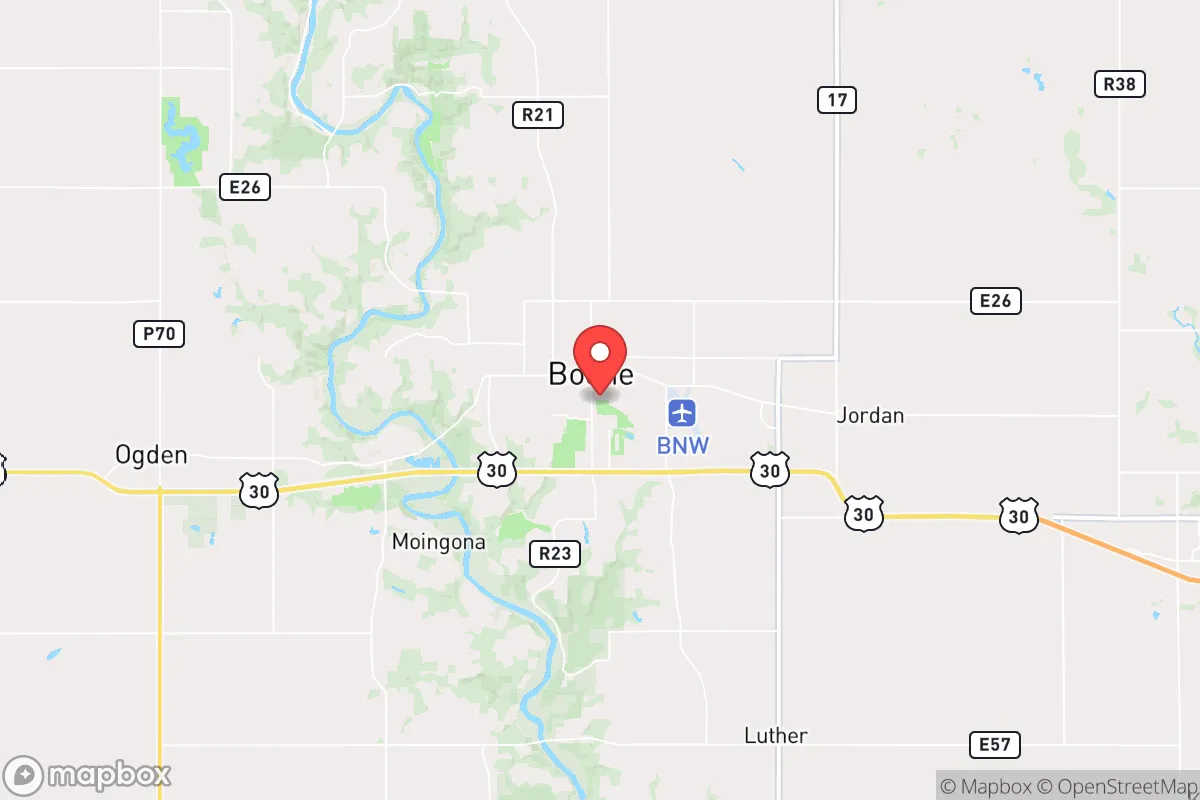
Boone, Iowa, sits in a sweet spot that few relocators fully appreciate: close enough to a major metro to access its logistics and medical infrastructure, yet far enough to avoid the blast radius of a high-value target or the chaos of a collapsing urban core. Located about 45 miles north of Des Moines along the Des Moines River valley, this town of roughly 12,000 people offers a blend of agricultural self-sufficiency, rail and highway connectivity, and a low-profile demographic that makes it a viable fallback position for those thinking in terms of decades, not just election cycles. The area’s resilience isn’t flashy—it’s built on hard ground, reliable water, and a community that still knows how to fix things without a smartphone.
Geographic position and natural advantages for long-term security
Boone’s geography is its first and strongest asset. The Des Moines River cuts through the western edge of town, providing a perennial surface water source that doesn’t depend on deep aquifers or municipal treatment plants to remain usable. The surrounding terrain is rolling glacial till—good drainage, decent soil, and enough tree cover to break sightlines without creating a dense forest that could become a fire hazard or a hiding place for unwanted visitors. The town sits on the eastern edge of the Loess Hills transition zone, which means the land rises gently to the west, offering elevated positions with clear views of the river valley. For a prepper mindset, that’s a natural defensive advantage: you can see threats coming from miles away, and the river itself acts as a barrier to vehicle movement from the west. The area also sits atop the Dakota Sandstone aquifer, one of the most reliable groundwater sources in the Midwest, which means well drilling is a realistic option for those who want to cut the municipal cord. Winters are cold enough to kill off most pests and pathogens, but not so extreme that they make year-round habitation a survival ordeal—average January lows hover around 12°F, manageable with proper clothing and heating.
Risks, exposures, and proximity to fallout-relevant landmarks
No location is immune to risk, and Boone has its share of exposure that a strategic relocator must weigh. The most obvious concern is the proximity to Des Moines—45 miles as the crow flies, which puts Boone within the fallout plume zone of a nuclear strike on the state capital. Des Moines is home to the Iowa National Guard headquarters, several Fortune 500 corporate HQs, and a major interstate junction (I-35 and I-80), making it a plausible target in a conflict with a peer adversary. Prevailing winds in central Iowa blow from the northwest to the southeast, which means fallout from a Des Moines strike would likely drift toward the eastern suburbs, not directly over Boone—but that’s a statistical comfort, not a guarantee. A more immediate risk is the Boone Generating Station, a coal-fired power plant just south of town that could become a secondary target or a source of environmental contamination if damaged. The plant’s coal ash ponds have been a point of local concern for years, and in a collapse scenario, the site could leach heavy metals into the river. On the plus side, Boone has no major military bases, no nuclear reactors, no chemical depots, and no major rail hubs for hazardous materials—it’s a low-priority target in any rational adversary’s targeting plan. The biggest man-made risk is the Union Pacific rail line that runs through town, carrying freight that could include anything from grain to anhydrous ammonia; a derailment near the river could be a localized disaster, but not a civilization-ending one.
Practical resilience for a relocator: food, water, energy, and defensibility
For someone serious about self-sufficiency, Boone checks most of the practical boxes. The surrounding county (Boone County) is heavily agricultural—corn, soybeans, and livestock operations dominate the landscape. That means local food production is not a theoretical possibility but an existing reality. Farmers’ markets operate in town during the growing season, and the presence of grain elevators and feed stores means bulk food storage is feasible without raising eyebrows. Water is the stronger play: the Des Moines River is a reliable surface source, and the shallow groundwater table in the river valley means hand pumps or solar-powered wells can produce potable water at depths of 30-50 feet in many areas. The town’s municipal water comes from the river and is treated at a plant that could be overwhelmed in a prolonged grid-down scenario, so having a backup filtration system (Berkey, Sawyer, or a DIY sand filter) is non-negotiable. Energy resilience is middling but improvable. The grid is served by MidAmerican Energy, which has a mix of coal, wind, and natural gas generation—reliable under normal conditions but vulnerable to cascading failures. Solar potential is decent: central Iowa gets about 200 sunny days per year, enough for a modest off-grid system with battery storage. Natural gas is piped into town, but a prepper should plan for propane backup or wood heat, since gas lines can be shut off or ruptured. Defensibility is where Boone shines relative to suburban sprawl. The town’s layout is compact—most residential areas are within a 15-minute walk of the river or the main commercial corridor—which makes it possible to establish neighborhood watch-style security perimeters. The surrounding farmland provides open fields of fire for anyone defending a rural homestead, and the river itself creates a natural chokepoint for vehicle access from the west. The local sheriff’s office is small (about 20 deputies), so don’t expect rapid response in a crisis; you’re the first line of defense.
The overall strategic picture for Boone is one of quiet viability. It’s not a prepper paradise—you won’t find bunkers, militia compounds, or a community that openly discusses collapse scenarios over coffee. What you will find is a place where the basics of survival are still within reach: clean water, fertile soil, a low crime rate, and a population that hasn’t been softened by decades of urban dependency. The downsides are real—proximity to a potential target, a coal plant that could become a liability, and a winter climate that demands preparation—but they’re manageable for someone who shows up with skills, supplies, and a realistic plan. For a conservative-leaning relocator who wants to be within striking distance of Des Moines’ hospitals and supply chains but far enough to breathe when the sirens go off, Boone offers a solid foundation. It’s not the end of the world—but if the world as we know it takes a hit, this is a place where you can still build something worth defending.
* Values derived from national, state, county, city and local statistics and may differ in a specific area. Last updated: 2026-04-30T00:23:41.000Z
Narrative content on this page is AI-generated and may contain mistakes. Verify any details that matter before acting on them.
ReloMaps may earn a commission from affiliate links at no extra cost to you.