
Photo: Wikipedia
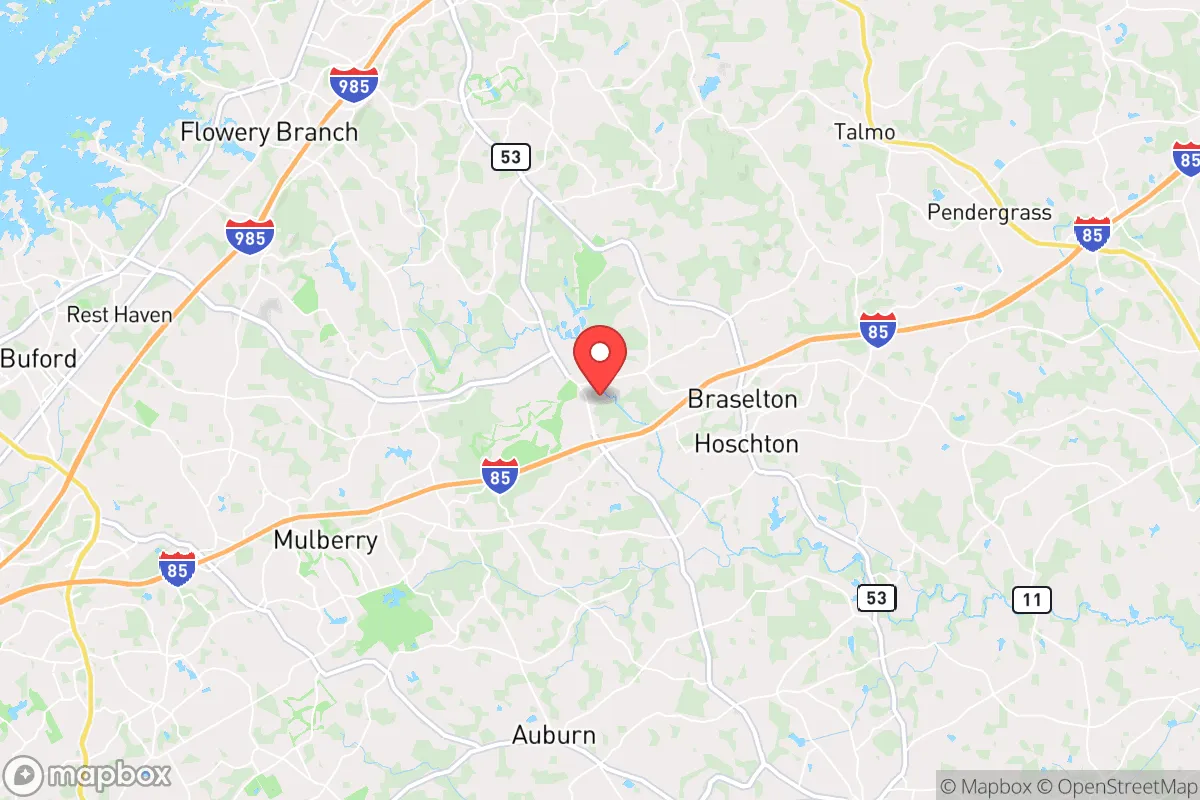
Strategic Assessment of Braselton, GA
Workable tactical position. Some exposure to population density or targets, but generally defensible in a crisis.
What does the Strategic Assessment tell us?
Our Strategic Assessment grades tactical survivability of an area. Major population centers, military targets, fallout zones, natural disasters, and border exposure all drive risk — lower exposure means a more defensible position in a crisis.
This is heavily inspired by Joel Skousen's Strategic Relocation book. Highly recommended you checkout the book ($)What does this tell us?
Our Strategic Assessment grades tactical survivability of an area. Major population centers, military targets, fallout zones, natural disasters, and border exposure all drive risk — lower exposure means a more defensible position in a crisis.
This is heavily inspired by Joel Skousen's Strategic Relocation book. Highly recommended you checkout the book ($)Strategic Pillars

Key Distances
Regional Safe Places
Below is our recommended "safe zones" in Georgia and the surrounding area based on our strategic heuristics. For most people, it's unrealistic to live in a “safe zone” full-time due to work, family or other personal reasons. They tend to be more rural. However, many of these areas are perfect for second homes and retreat properties that double as a vacation home or even a short-term rental.


Important Note: For informational purposes only. This does not mean nothing bad ever happens in the green zones. Please use common sense. This is based on public data and modeled with AI. We tried to take a conservative approach but mistakes happen. We update this regularly as new information becomes available.
Solar Generator Recommendations
Backup power matters more here than in safer locations. We've picked three solar generators across budgets and capacity tiers — start with the budget unit if you only need a few essentials, or step up if you want to run a fridge and HVAC for days at a time.

Jackery Portable Power Station Explorer 300
Budget OptionPower on the Go: Weighing only 11 lbs, it's convenient to set up and store with book-sized foldable solar panels

BLUETTI Portable Power Station AC180
Designed for both indoor and outdoor scenarios, AC180 is highly capable as it has a robost capacity and continuous output power.

EF ECOFLOW DELTA Pro Ultra Power Station
Upgraded PickEcoFlow DELTA Pro Ultra is a whole-home energy system designed to grow with your family. Integrated with the Smart Home Panel 2, it scales to meet your evolving energy needs — keeping your home powered, intelligent, and secure through every stage of life.
We earn a commission, at no additional cost to you.
Strategic Assessment Analysis
Braselton, Georgia, sits in a strategic sweet spot that few relocation analysts fully appreciate: it straddles four counties (Jackson, Barrow, Gwinnett, and Hall) while remaining far enough from Atlanta’s urban core to avoid the worst of a metropolitan collapse, yet close enough to leverage its logistics and medical infrastructure. This geographic positioning gives a relocator a genuine resilience advantage — you’re not in the blast radius of a major city, but you’re not stranded in a rural dead zone either. The area’s growth has been steady but not explosive, meaning infrastructure has kept pace with population, and the local economy is diversified enough to absorb shocks. For someone thinking in terms of decades, not election cycles, Braselton offers a rare combination of defensible distance and practical access.
Geographic position and natural advantages for long-term security
Braselton sits roughly 50 miles northeast of Atlanta, placing it well outside the likely fallout zone of any major metropolitan target, yet within a two-hour drive of Hartsfield-Jackson, the world’s busiest airport, if evacuation or supply runs become necessary. The area is anchored by the foothills of the North Georgia mountains, which provide natural terrain barriers, elevation advantages, and abundant water sources. The Chattahoochee River system runs through the region, and the nearby Lake Lanier — the state’s largest reservoir — offers a massive freshwater buffer that could sustain a community through extended drought or infrastructure failure. The local topography is rolling hills with mixed hardwood forest, which provides both concealment and natural windbreaks, and the clay-heavy soil is workable for gardening if you’re willing to amend it. The climate is humid subtropical, with four distinct seasons, which means you can grow food year-round with season extension techniques, and you’re unlikely to face the kind of extreme weather that collapses whole regions — no hurricane storm surge, no wildfire corridors, no earthquake zones.
Risks, exposures, and proximity to fallout-relevant landmarks
The most significant risk for Braselton is its proximity to the Atlanta metropolitan area’s sprawling suburban edge. While the town itself is small (population roughly 13,000 as of 2025), it sits within a 30-mile radius of several high-value targets: the Port of Savannah’s inland rail hub in nearby Gainesville, the Buford Dam on Lake Lanier, and multiple major interstate corridors (I-85, I-985, GA-316) that would become choke points during any evacuation or civil unrest event. The presence of the Northeast Georgia Medical Center in Gainesville, a Level II trauma center, is a double-edged sword — it’s a critical resource for medical emergencies, but it also makes the region a potential magnet for refugees fleeing Atlanta in a crisis. The area’s power grid is served by Georgia Power and Jackson EMC, both of which have above-average reliability, but the region is not immune to the kind of cascading grid failures seen in winter storms like 2014’s Snowpocalypse. There are no nuclear power plants within 50 miles, but the proximity to major transportation corridors means hazardous material spills from trucks or trains are a real, if low-probability, risk. The biggest exposure is social, not physical: Braselton’s rapid growth has brought in a mix of exurban commuters, retirees, and second-home owners, which means the community lacks the deep social cohesion of a rural town that has been there for generations. In a prolonged crisis, that lack of trust networks could become a liability.
Practical resilience for a relocator: food, water, energy, and defensibility
For someone serious about self-sufficiency, Braselton offers a workable baseline. The water situation is strong: most homes are on well water or municipal systems fed by the Chattahoochee and Lake Lanier, and the water table is generally high enough that a hand pump or solar-powered well can be a realistic backup. The soil, while clay-heavy, can be amended with compost and raised beds to produce vegetables, and the growing season runs from April to October, with a mild winter that allows for cold-hardy greens and root crops. Local farmers’ markets and the nearby Braselton Farmers Market provide a network for sourcing seeds, livestock, and knowledge, and the presence of Tractor Supply and local feed stores means you can stockpile supplies without drawing attention. Energy resilience is more challenging: the grid is reliable day-to-day, but solar is viable here — the area averages 218 sunny days per year, slightly above the national average — and many homes have the roof orientation and lot size to support a modest off-grid system. Natural gas is available in most subdivisions, which is a plus for cooking and heating during grid outages. Defensibility is moderate: the town is laid out along a main commercial corridor (GA-211) with residential neighborhoods branching off into cul-de-sacs and rural roads, which creates natural chokepoints. The terrain is not mountainous enough to provide true tactical advantage, but the forested lots and winding roads make it hard for a large group to move through undetected. The biggest practical weakness is the lack of a strong local food-processing infrastructure — there are no major grain mills, meat processors, or canneries within 20 miles, so you’d need to build those capabilities yourself or form a cooperative with neighbors.
The overall strategic picture for Braselton is one of cautious optimism for the prepared relocator. It is not a hardened survivalist redoubt — it lacks the isolation, the community bunker culture, and the extreme terrain of a Montana or Idaho retreat. But it is a place where a disciplined individual or family can build a resilient life without cutting ties to modern civilization entirely. The proximity to Atlanta is a risk, but it is also a resource: you can access specialized medical care, hardware supplies, and information networks that a truly remote location cannot offer. The key is to treat Braselton as a base of operations, not a fortress — invest in water storage, solar backup, food production, and community relationships, and you will be far better positioned than 90% of Americans when the next crisis hits. The area’s growth trajectory suggests it will become more suburban over the next decade, so the time to act is now, while land is still affordable and the social fabric is still loose enough to weave yourself into it on your own terms.
* Values derived from national, state, county, city and local statistics and may differ in a specific area. Last updated: 2026-04-23T05:27:03.000Z
Narrative content on this page is AI-generated and may contain mistakes. Verify any details that matter before acting on them.
ReloMaps may earn a commission from affiliate links at no extra cost to you.