Photo: Wikipedia
Strategic Assessment of Bridgeville, DE
Multiple tactical vulnerabilities. Population density, target proximity, or disaster risk are likely compounding. A retreat property and exit planning is required.
What does the Strategic Assessment tell us?
Our Strategic Assessment grades tactical survivability of an area. Major population centers, military targets, fallout zones, natural disasters, and border exposure all drive risk — lower exposure means a more defensible position in a crisis.
This is heavily inspired by Joel Skousen's Strategic Relocation book. Highly recommended you checkout the book ($)What does this tell us?
Our Strategic Assessment grades tactical survivability of an area. Major population centers, military targets, fallout zones, natural disasters, and border exposure all drive risk — lower exposure means a more defensible position in a crisis.
This is heavily inspired by Joel Skousen's Strategic Relocation book. Highly recommended you checkout the book ($)Strategic Pillars

Key Distances
Regional Safe Places
Below is our recommended "safe zones" in Delaware and the surrounding area based on our strategic heuristics. For most people, it's unrealistic to live in a “safe zone” full-time due to work, family or other personal reasons. They tend to be more rural. However, many of these areas are perfect for second homes and retreat properties that double as a vacation home or even a short-term rental.


Important Note: For informational purposes only. This does not mean nothing bad ever happens in the green zones. Please use common sense. This is based on public data and modeled with AI. We tried to take a conservative approach but mistakes happen. We update this regularly as new information becomes available.
Solar Generator Recommendations
Backup power matters more here than in safer locations. We've picked three solar generators across budgets and capacity tiers — start with the budget unit if you only need a few essentials, or step up if you want to run a fridge and HVAC for days at a time.

Jackery Portable Power Station Explorer 300
Budget OptionPower on the Go: Weighing only 11 lbs, it's convenient to set up and store with book-sized foldable solar panels

BLUETTI Portable Power Station AC180
Designed for both indoor and outdoor scenarios, AC180 is highly capable as it has a robost capacity and continuous output power.

EF ECOFLOW DELTA Pro Ultra Power Station
Upgraded PickEcoFlow DELTA Pro Ultra is a whole-home energy system designed to grow with your family. Integrated with the Smart Home Panel 2, it scales to meet your evolving energy needs — keeping your home powered, intelligent, and secure through every stage of life.
We earn a commission, at no additional cost to you.
Strategic Assessment Analysis
Bridgeville, Delaware, presents a nuanced strategic picture for the conservative prepper or survivalist. It offers a degree of resilience through its small-town character and agricultural base, but its proximity to major population centers and critical infrastructure introduces significant risks that must be weighed carefully. This assessment examines the town's location, its exposure to threats, and the practical realities of living there from a preparedness standpoint, focusing on the factors that matter most when planning for civic unrest, mass casualty events, and large-scale disasters.
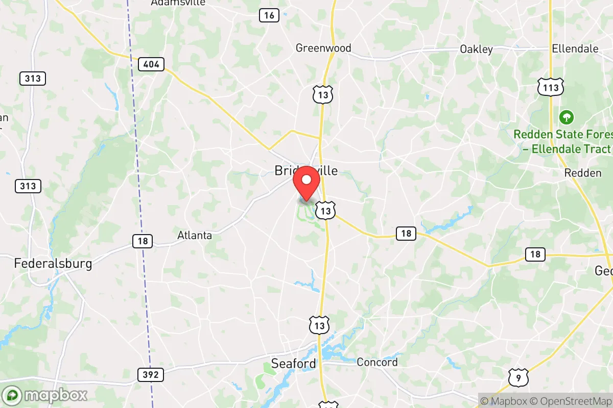
Geographic position and natural advantages for long-term stability
Bridgeville sits in western Sussex County, roughly 20 miles from the Delaware Bay and 30 miles from the Atlantic Ocean. This inland position provides a buffer against the most severe impacts of hurricane storm surge and sea-level rise, which are genuine concerns for coastal communities like Rehoboth Beach or Lewes. The area is part of the Delmarva Peninsula, a region that is geographically isolated by the Chesapeake and Delaware Bays, creating a natural chokepoint for movement. The primary road access is via US Route 13 and State Route 404, which connect to the Chesapeake Bay Bridge and the Delaware Memorial Bridge—both potential bottlenecks in a crisis. The terrain is flat and agricultural, with sandy loam soils that support farming but offer little in the way of natural defensive cover. The climate is temperate, with hot, humid summers and mild winters, which reduces the risk of extreme cold-related survival challenges but increases the need for reliable cooling and water management. The area's primary natural advantage is its groundwater supply: the Columbia Aquifer underlies much of Sussex County and provides relatively abundant, shallow freshwater, a critical resource for long-term self-sufficiency.
Risks, exposures, and proximity to fallout-relevant landmarks
The most significant strategic drawback of Bridgeville is its location within the Washington-Baltimore-Philadelphia megalopolis. While the town itself is small (population around 2,500), it lies within a 90-minute drive of over 10 million people. In a scenario involving civil unrest, mass evacuation, or a major disaster, this population density translates directly into risk. The primary threat is not a direct attack on Bridgeville but the cascading effects of a crisis in nearby urban centers. Refugees, supply chain disruptions, and the potential for looting or violence could spill into the area. Furthermore, the Delmarva Peninsula is home to several high-value targets. The Indian River Power Plant, a coal and natural gas facility, is about 25 miles east. The Dover Air Force Base, a major logistics hub, is 30 miles north. The Salem Nuclear Power Plant in New Jersey is roughly 40 miles northeast across the Delaware Bay. Any of these could become a focal point for fallout, whether from a conventional attack, a terrorist incident, or a catastrophic accident. The proximity to the Chesapeake Bay Bridge and the Delaware Memorial Bridge also makes these structures potential targets or chokepoints that could be compromised, effectively trapping residents on the peninsula. For a relocator, the key question is whether the isolation of the peninsula outweighs the risk of being trapped there.
Practical resilience for a relocator: food, water, energy, and defensibility
Bridgeville's agricultural setting offers genuine advantages for food security. The surrounding farmland produces corn, soybeans, and poultry, and the town itself has a small but functional agricultural infrastructure, including feed stores and equipment dealers. A prepper could realistically establish a substantial garden, raise chickens or rabbits, and source bulk grains locally. The shallow water table means that a hand-dug well or a driven point well is feasible on most properties, providing a backup water source independent of municipal systems. However, the energy picture is less favorable. The grid is served by Delmarva Power, which relies on a mix of fossil fuels and renewables, but the area is prone to outages from storms and high demand. Solar panels are a viable option given the region's moderate sun exposure, but battery storage is essential for nighttime and cloudy periods. Defensibility is a mixed bag. The flat, open terrain offers little natural cover, and the town's layout—a traditional small town with a central square and surrounding residential streets—is not designed for perimeter defense. A rural property with a long driveway and good sightlines would be far more defensible than a house in town. The local law enforcement presence is limited; the Bridgeville Police Department is small, and the Sussex County Sheriff's Office covers a vast area. In a prolonged crisis, residents would largely need to rely on themselves and their immediate neighbors. The social fabric of the town is a double-edged sword: a tight-knit community can be a force multiplier for mutual aid, but it also means that outsiders may be viewed with suspicion, and integrating into local networks takes time and effort.
The overall strategic picture for Bridgeville is one of calculated trade-offs. It offers a genuine agricultural base, a decent water supply, and a degree of geographic isolation from the worst coastal threats. But it sits within the shadow of major population centers and critical infrastructure that could become sources of danger in a national crisis. For a single individual or a family willing to invest in off-grid systems, build strong local relationships, and maintain a low profile, Bridgeville could serve as a viable retreat. The key is to recognize that its resilience is conditional: it depends on the nature of the disaster, the state of the bridges, and the behavior of the surrounding population. It is not a fortress, but it is a place where a prepared person could carve out a sustainable existence if they are realistic about the risks and committed to the work.
* Values derived from national, state, county, city and local statistics and may differ in a specific area. Last updated: 2026-04-30T04:02:47.000Z
Narrative content on this page is AI-generated and may contain mistakes. Verify any details that matter before acting on them.
ReloMaps may earn a commission from affiliate links at no extra cost to you.