Photo: Wikipedia
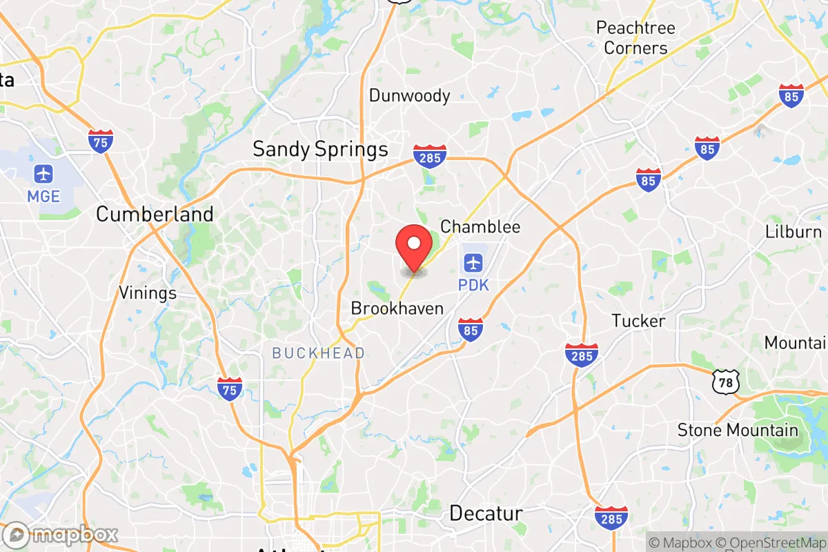
Strategic Assessment of Brookhaven, GA
Multiple tactical vulnerabilities. Population density, target proximity, or disaster risk are likely compounding. A retreat property and exit planning is required.
What does the Strategic Assessment tell us?
Our Strategic Assessment grades tactical survivability of an area. Major population centers, military targets, fallout zones, natural disasters, and border exposure all drive risk — lower exposure means a more defensible position in a crisis.
This is heavily inspired by Joel Skousen's Strategic Relocation book. Highly recommended you checkout the book ($)What does this tell us?
Our Strategic Assessment grades tactical survivability of an area. Major population centers, military targets, fallout zones, natural disasters, and border exposure all drive risk — lower exposure means a more defensible position in a crisis.
This is heavily inspired by Joel Skousen's Strategic Relocation book. Highly recommended you checkout the book ($)Strategic Pillars

Key Distances
Regional Safe Places
Below is our recommended "safe zones" in Georgia and the surrounding area based on our strategic heuristics. For most people, it's unrealistic to live in a “safe zone” full-time due to work, family or other personal reasons. They tend to be more rural. However, many of these areas are perfect for second homes and retreat properties that double as a vacation home or even a short-term rental.


Important Note: For informational purposes only. This does not mean nothing bad ever happens in the green zones. Please use common sense. This is based on public data and modeled with AI. We tried to take a conservative approach but mistakes happen. We update this regularly as new information becomes available.
Solar Generator Recommendations
Backup power matters more here than in safer locations. We've picked three solar generators across budgets and capacity tiers — start with the budget unit if you only need a few essentials, or step up if you want to run a fridge and HVAC for days at a time.

Jackery Portable Power Station Explorer 300
Budget OptionPower on the Go: Weighing only 11 lbs, it's convenient to set up and store with book-sized foldable solar panels

BLUETTI Portable Power Station AC180
Designed for both indoor and outdoor scenarios, AC180 is highly capable as it has a robost capacity and continuous output power.

EF ECOFLOW DELTA Pro Ultra Power Station
Upgraded PickEcoFlow DELTA Pro Ultra is a whole-home energy system designed to grow with your family. Integrated with the Smart Home Panel 2, it scales to meet your evolving energy needs — keeping your home powered, intelligent, and secure through every stage of life.
We earn a commission, at no additional cost to you.
Strategic Assessment Analysis
Brookhaven, Georgia, sits in a precarious strategic position that demands a clear-eyed assessment from anyone serious about resilience. Its location just northeast of Atlanta offers immediate access to urban resources, but that proximity is a double-edged sword in a crisis scenario. For the conservative prepper, Brookhaven presents a trade-off: you get the economic stability of a well-off suburb, but you are also tethered to one of the most congested, politically volatile, and infrastructure-strained metro areas in the Southeast. The city’s resilience is not inherent; it is contingent on your ability to decouple from Atlanta’s vulnerabilities while leveraging its logistical advantages.
Geographic position and natural advantages for long-term survival
Brookhaven’s geography is defined by its position within the Piedmont region, offering rolling hills, clay-based soils, and a temperate climate that supports year-round gardening and water collection. The city is bisected by Peachtree Creek, a tributary of the Chattahoochee River, which provides a natural water source—though one that requires filtration and treatment in a grid-down scenario. The area’s tree canopy is dense, offering some concealment and shade, but it also creates a fuel load for wildfires during dry spells. Elevation ranges from roughly 900 to 1,000 feet above sea level, which is modest but sufficient to avoid most floodplain risks. The Chattahoochee River National Recreation Area lies just to the west, offering a potential bug-out corridor and a reliable water supply, though it is heavily trafficked by hikers and day-trippers in normal times. For the relocator, the key natural advantage is the moderate climate: no hurricane storm surge, no earthquake zones, and only occasional tornado warnings. Winters are mild enough that heating fuel demands are low, and summers, while humid, allow for robust food production if you have the land and the know-how.
Risks, exposures, and proximity to fallout-relevant landmarks
The single greatest risk to a Brookhaven-based prepper is its proximity to Atlanta—specifically, the city’s role as a transportation and government hub. Hartsfield-Jackson Atlanta International Airport, the world’s busiest, is roughly 20 miles south. In a mass-casualty event, a biological outbreak, or a coordinated attack, that airport becomes a primary vector for contagion and a target for disruption. The Centers for Disease Control and Prevention (CDC) is located just 10 miles southwest in Atlanta’s Druid Hills neighborhood. While the CDC is a public health asset, its presence also makes the metro area a potential ground zero for accidental or intentional pathogen release. Brookhaven is also within the blast radius of multiple rail lines carrying hazardous materials through the city’s core, including the CSX and Norfolk Southern mainlines that run through DeKalb County. A derailment or sabotage event could release toxic chemicals or disrupt supply chains for weeks. Additionally, the city is surrounded by high-value soft targets: the Lenox Square and Phipps Plaza malls, the Buckhead financial district, and the MARTA rail system. In a civil unrest scenario, these areas would likely see looting, crowd concentration, and law enforcement diversion. Brookhaven’s own police force is well-funded—the city levies a dedicated sales tax for public safety—but it is a small department (roughly 60 officers) that would be overwhelmed if Atlanta’s chaos spilled north.
Practical resilience for a relocator: food, water, energy, and defensibility
For the individual or family looking to establish a resilient foothold, Brookhaven offers a mixed bag. Water security is the most immediate concern. The city draws its municipal water from the Chattahoochee River via the DeKalb County system, which is vulnerable to contamination, pump failure, or cyberattack. A well is not a realistic option for most properties due to the clay soil and shallow water table (typically 20–40 feet, but often contaminated with iron and bacteria). Rainwater catchment is legal in Georgia, but homeowners associations (HOAs) in Brookhaven’s many planned communities may restrict visible barrels or cisterns. Food production is feasible on lots of a quarter-acre or larger, but the city’s zoning code limits livestock to chickens only (no goats, pigs, or cattle). Community gardens exist but are small and not defensible. Energy independence is hampered by the city’s tree cover—solar panels on a typical suburban roof will see significant shading, reducing output by 20–30% compared to an open field. Natural gas is the primary heating fuel, and the pipeline infrastructure is aging; a prolonged outage would leave residents reliant on propane or wood, both of which require storage space that many lots lack. Defensibility is the weakest link. Brookhaven is a dense, interconnected suburb with multiple entry points via Peachtree Road, Buford Highway, and I-85. There are no natural chokepoints, and the street grid is designed for flow, not security. A single-family home on a corner lot offers limited standoff distance. The best defensive posture is a home on a cul-de-sac with a rear tree line and a single access road—properties exist in the Ashford Park and Murphey Candler neighborhoods, but they command a premium. For the relocator, the practical takeaway is that Brookhaven requires active hardening: reinforced doors, window film, a backup power system (generator or battery), and a stored water supply of at least 50 gallons per person. Without these, the city’s comforts become liabilities.
The overall strategic picture for Brookhaven is one of calculated risk. It is not a bug-out location—it is a situational awareness outpost for those who need to remain close to Atlanta’s economic engine but are willing to invest in layered defenses. The city’s tax base is strong, its schools are well-regarded (Druid Hills High School and Chamblee High School both offer STEM and vocational tracks), and its crime rates are below the national average for property and violent crime. But those statistics assume a functioning society. In a grid-down scenario, Brookhaven’s density, its reliance on fragile infrastructure, and its proximity to high-value targets make it a high-risk, high-maintenance location. The conservative prepper who chooses Brookhaven must be prepared to be a minority voice in a politically liberal county (DeKalb voted 83% for Biden in 2020), which could create social friction during a crisis. The smart play is to treat Brookhaven as a base of operations, not a final redoubt. Establish a secondary property in a lower-density county—north toward Dawsonville or west toward Carrollton—and maintain a rotation of supplies between the two. Brookhaven gives you the resources; the hinterland gives you the breathing room. That dual-location strategy is the only way to square the city’s undeniable advantages with its equally undeniable vulnerabilities.
* Values derived from national, state, county, city and local statistics and may differ in a specific area. Last updated: 2026-04-29T18:01:14.000Z
Narrative content on this page is AI-generated and may contain mistakes. Verify any details that matter before acting on them.
ReloMaps may earn a commission from affiliate links at no extra cost to you.