Photo: Wikipedia
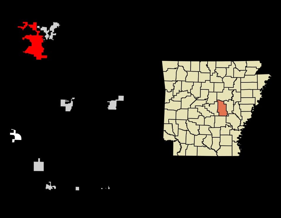
Strategic Assessment of Cabot, AR
Workable tactical position. Some exposure to population density or targets, but generally defensible in a crisis.
What does the Strategic Assessment tell us?
Our Strategic Assessment grades tactical survivability of an area. Major population centers, military targets, fallout zones, natural disasters, and border exposure all drive risk — lower exposure means a more defensible position in a crisis.
This is heavily inspired by Joel Skousen's Strategic Relocation book. Highly recommended you checkout the book ($)What does this tell us?
Our Strategic Assessment grades tactical survivability of an area. Major population centers, military targets, fallout zones, natural disasters, and border exposure all drive risk — lower exposure means a more defensible position in a crisis.
This is heavily inspired by Joel Skousen's Strategic Relocation book. Highly recommended you checkout the book ($)Strategic Pillars

Key Distances
Regional Safe Places
Below is our recommended "safe zones" in Arkansas and the surrounding area based on our strategic heuristics. For most people, it's unrealistic to live in a “safe zone” full-time due to work, family or other personal reasons. They tend to be more rural. However, many of these areas are perfect for second homes and retreat properties that double as a vacation home or even a short-term rental.


Important Note: For informational purposes only. This does not mean nothing bad ever happens in the green zones. Please use common sense. This is based on public data and modeled with AI. We tried to take a conservative approach but mistakes happen. We update this regularly as new information becomes available.
Solar Generator Recommendations
Backup power matters more here than in safer locations. We've picked three solar generators across budgets and capacity tiers — start with the budget unit if you only need a few essentials, or step up if you want to run a fridge and HVAC for days at a time.

Jackery Portable Power Station Explorer 300
Budget OptionPower on the Go: Weighing only 11 lbs, it's convenient to set up and store with book-sized foldable solar panels

BLUETTI Portable Power Station AC180
Designed for both indoor and outdoor scenarios, AC180 is highly capable as it has a robost capacity and continuous output power.

EF ECOFLOW DELTA Pro Ultra Power Station
Upgraded PickEcoFlow DELTA Pro Ultra is a whole-home energy system designed to grow with your family. Integrated with the Smart Home Panel 2, it scales to meet your evolving energy needs — keeping your home powered, intelligent, and secure through every stage of life.
We earn a commission, at no additional cost to you.
Strategic Assessment Analysis
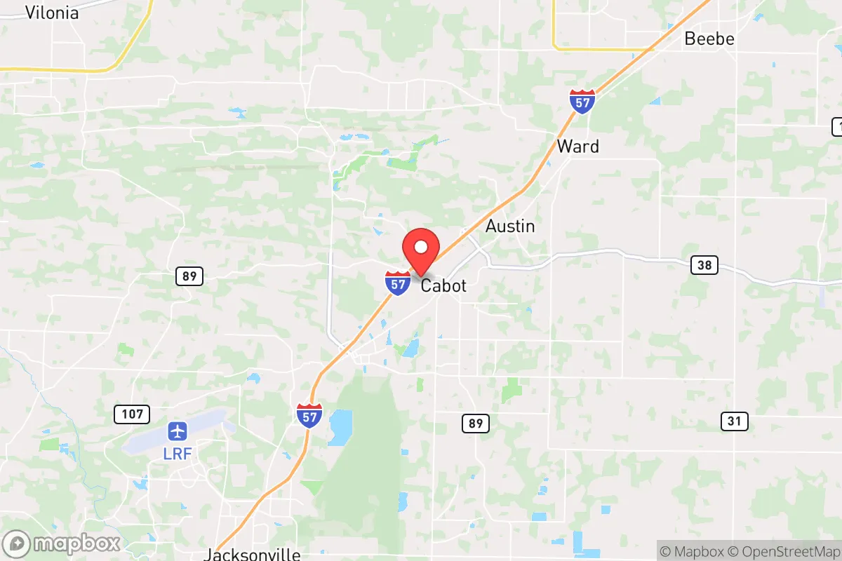
Cabot, Arkansas, sits in a position that demands a hard look from anyone serious about strategic relocation. It’s not a bunker in the mountains, but it offers a blend of suburban stability and rural access that many preppers find workable—provided you understand its real vulnerabilities. The town’s resilience comes down to its location on the I-40 corridor between Little Rock and Memphis, its position within the Arkansas River Valley, and the fact that it’s far enough from major urban centers to avoid the worst of a collapse scenario, yet close enough to supply chains and medical infrastructure to matter in a slow-burn crisis. For a conservative-leaning relocator thinking about civic unrest, mass casualty events, or long-term disruption, Cabot is a middle-ground option that rewards careful planning and punishes complacency.
Geographic position and natural advantages for long-term stability
Cabot’s geographic anchor is its location in Lonoke County, roughly 30 miles northeast of Little Rock and about 100 miles west of Memphis. That puts it outside the immediate blast radius of any major population center, but still within a day’s drive of two significant cities. The Arkansas River Valley provides fertile soil, decent rainfall (averaging about 50 inches annually), and access to the Arkansas River itself, which is a major navigable waterway. The Ozark and Ouachita Mountains to the north and west offer natural barriers and potential retreat zones if things go truly sideways. The terrain around Cabot is mostly rolling hills and farmland—not defensible like mountain passes, but not a flat kill zone either. The area sits in USDA Hardiness Zone 7b, meaning a long growing season for food production, and the local water table is generally good for wells, though you’ll want to test depth and quality before buying. The climate is humid subtropical, with hot summers and mild winters, which reduces the risk of catastrophic winter storms that can cripple northern states. Tornadoes are the primary natural threat, but that’s a known risk you can mitigate with a storm shelter—something many locals already have.
Risks, exposures, and proximity to fallout-relevant landmarks
Cabot’s biggest strategic weakness is its proximity to Little Rock, which is a regional hub for government, military, and transportation infrastructure. Little Rock Air Force Base, home to the 19th Airlift Wing and C-130 operations, is just 15 miles southwest of Cabot. In a mass casualty event or major conflict, that base becomes a primary target. Fallout patterns depend on wind direction, but prevailing winds in Arkansas are generally from the south and southwest, meaning a strike on Little Rock could push fallout toward Cabot. The I-40 corridor itself is a double-edged sword: it’s a vital supply route, but in a crisis it becomes a chokepoint for refugees fleeing Memphis or Little Rock. Expect roadblocks, checkpoints, and potential violence if civil order breaks down. The nearby Arkansas Nuclear One power plant in Russellville (about 70 miles northwest) is another consideration—while not an immediate fallout risk, a catastrophic failure there could affect water and food supplies across the region. Cabot also sits near the New Madrid Seismic Zone, which has a history of major earthquakes (the 1811-1812 series). A significant quake could disrupt the Mississippi River and I-40, cutting off supply lines and causing structural damage. The town’s reliance on the grid and municipal water means you’re exposed to cascading failures if the power goes out for weeks. In short, Cabot is not a remote survivalist paradise—it’s a suburban buffer zone with real exposure to regional collapse.
Practical resilience for a relocator: food, water, energy, and defensibility
For someone serious about self-sufficiency, Cabot offers a mixed bag. The soil is good for gardening, and the growing season runs from April to October, allowing for two crop cycles of staples like beans, corn, and squash. Local farmers’ markets and co-ops exist, but they’re not robust enough to rely on in a crisis—you’ll need to establish your own food production. Water is the bigger concern: municipal water comes from the Arkansas River and local aquifers, but treatment plants are vulnerable to contamination and power loss. A well is your best bet, but drilling costs in Lonoke County run $15-$30 per foot, and depths vary from 100 to 400 feet. Rainwater catchment is legal and practical, given the annual rainfall. Energy-wise, Cabot is served by Entergy Arkansas, which has a mixed reliability record. Solar is viable—the area gets about 4.5 peak sun hours per day—but grid-tied systems are common; off-grid setups require battery storage and backup generators. Natural gas is available in most subdivisions, which is useful for cooking and heating if the grid holds. Defensibility is the weakest point. Cabot is a suburban sprawl of subdivisions, strip malls, and schools. There’s no natural chokepoint or high ground to control access. Your best bet is a property on the outskirts with a long driveway, good visibility, and neighbors you know and trust. The local gun culture is strong—Arkansas is a constitutional carry state—and the sheriff’s office in Lonoke County is generally pro-Second Amendment. But in a mass casualty event or civil unrest, you’re not holding a perimeter against a mob; you’re relying on community networks and low profile. The town’s population of roughly 27,000 means you can know your neighbors, but it also means you’re not invisible.
The overall strategic picture for Cabot is one of calculated trade-offs. It’s not a bug-out location for a total collapse, but it’s a viable base for a slow decline scenario where you maintain a normal life while building resilience. You get decent land, water access, and a conservative-friendly legal environment, but you also get proximity to a major military target and a transportation corridor that will attract chaos. The smart play here is to treat Cabot as a staging ground: establish a home with a well, solar, and garden, but also have a secondary retreat in the Ozarks or Ouachitas for when the I-40 corridor becomes untenable. If you’re looking for a place to ride out the next decade with a job, a church, and a plan, Cabot works. If you’re expecting a Mad Max scenario, keep driving west. The key is knowing what you’re signing up for—and being honest about the risks before you buy the land.
* Values derived from national, state, county, city and local statistics and may differ in a specific area. Last updated: 2026-05-03T20:21:49.000Z
Narrative content on this page is AI-generated and may contain mistakes. Verify any details that matter before acting on them.
ReloMaps may earn a commission from affiliate links at no extra cost to you.