Photo: Wikipedia
Strategic Assessment of Carlisle, PA
Multiple tactical vulnerabilities. Population density, target proximity, or disaster risk are likely compounding. A retreat property and exit planning is required.
What does the Strategic Assessment tell us?
Our Strategic Assessment grades tactical survivability of an area. Major population centers, military targets, fallout zones, natural disasters, and border exposure all drive risk — lower exposure means a more defensible position in a crisis.
This is heavily inspired by Joel Skousen's Strategic Relocation book. Highly recommended you checkout the book ($)What does this tell us?
Our Strategic Assessment grades tactical survivability of an area. Major population centers, military targets, fallout zones, natural disasters, and border exposure all drive risk — lower exposure means a more defensible position in a crisis.
This is heavily inspired by Joel Skousen's Strategic Relocation book. Highly recommended you checkout the book ($)Strategic Pillars

Key Distances
Regional Safe Places
Below is our recommended "safe zones" in Pennsylvania and the surrounding area based on our strategic heuristics. For most people, it's unrealistic to live in a “safe zone” full-time due to work, family or other personal reasons. They tend to be more rural. However, many of these areas are perfect for second homes and retreat properties that double as a vacation home or even a short-term rental.


Important Note: For informational purposes only. This does not mean nothing bad ever happens in the green zones. Please use common sense. This is based on public data and modeled with AI. We tried to take a conservative approach but mistakes happen. We update this regularly as new information becomes available.
Solar Generator Recommendations
Backup power matters more here than in safer locations. We've picked three solar generators across budgets and capacity tiers — start with the budget unit if you only need a few essentials, or step up if you want to run a fridge and HVAC for days at a time.

Jackery Portable Power Station Explorer 300
Budget OptionPower on the Go: Weighing only 11 lbs, it's convenient to set up and store with book-sized foldable solar panels

BLUETTI Portable Power Station AC180
Designed for both indoor and outdoor scenarios, AC180 is highly capable as it has a robost capacity and continuous output power.

EF ECOFLOW DELTA Pro Ultra Power Station
Upgraded PickEcoFlow DELTA Pro Ultra is a whole-home energy system designed to grow with your family. Integrated with the Smart Home Panel 2, it scales to meet your evolving energy needs — keeping your home powered, intelligent, and secure through every stage of life.
We earn a commission, at no additional cost to you.
Strategic Assessment Analysis
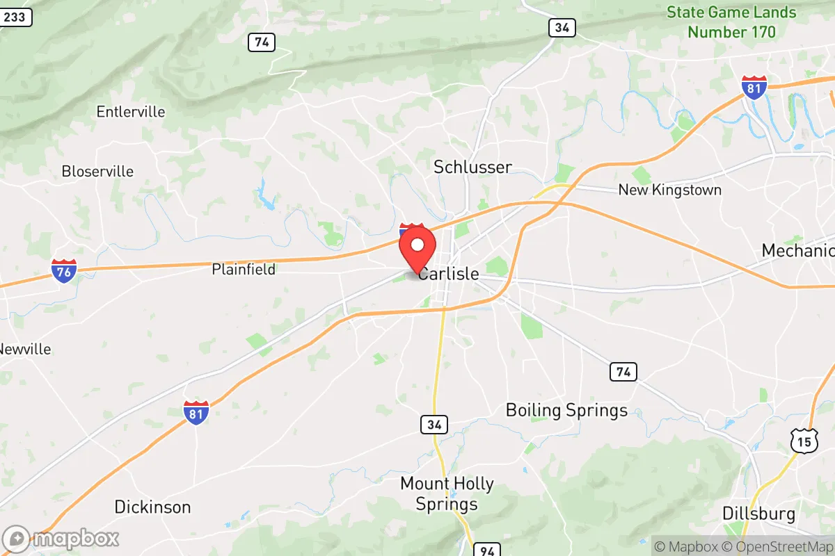
Carlisle, Pennsylvania, sits in a sweet spot that many preppers overlook: close enough to major infrastructure to be useful, but far enough from the primary blast zones and population centers to offer a genuine buffer. Its position along the I-81 and Pennsylvania Turnpike corridors gives it logistical reach, while the surrounding Cumberland Valley farmland provides a food-production base that most suburban sprawl zones have already paved over. For a relocator thinking in terms of decades, not just the next election cycle, Carlisle offers a mix of historical stability, agricultural depth, and geographic chokepoint control that makes it worth a hard look.
Geographic position and natural advantages for long-term security
Carlisle’s real asset is its location at the intersection of two major transportation arteries—I-81 running north-south and the Pennsylvania Turnpike (I-76) running east-west. That gives you options. If one route gets compromised by civil unrest, a natural disaster, or a supply-chain collapse, you have a secondary path. The town itself sits in the Cumberland Valley, a broad, fertile basin flanked by the Blue Mountain ridge to the north and South Mountain to the south. Those ridges aren’t just scenic; they create natural defensible terrain and limit the sprawl that makes cities like Harrisburg (18 miles east) so vulnerable to cascading failures. The valley’s limestone-based soil is some of the best agricultural land in the Northeast, meaning local food production isn’t a fantasy—it’s an existing industry. The Yellow Breeches Creek and the Conodoguinet Creek provide surface water sources, and the underlying aquifer is robust enough to support well drilling in most rural parcels just outside town limits. For a prepper, the combination of defensible terrain, water access, and arable land within a short drive of a county seat is rare this close to the I-95 megalopolis.
Risks, exposures, and proximity to fallout-relevant landmarks
No analysis is honest without naming the liabilities. Carlisle is 18 miles from Harrisburg, which houses the state capitol, the Three Mile Island nuclear plant (decommissioned but still holding spent fuel), and a major rail yard. That proximity means any large-scale event targeting government infrastructure—whether civil unrest, a coordinated attack, or a natural disaster triggering a hazmat release—could send ripple effects into the valley. The I-81 corridor itself is a double-edged sword: it’s your supply line, but it’s also a funnel for refugees fleeing the Baltimore-Washington corridor (about 90 miles south). In a mass evacuation scenario, Carlisle could become a chokepoint where fleeing populations get stuck, creating secondary risks of resource competition and civil disorder. The town also sits within 50 miles of the Letterkenny Army Depot (a major ammunition storage and demilitarization site) and the Naval Support Activity Mechanicsburg. These are strategic military assets that could become targets or, in a crisis, generate their own security perimeters that disrupt civilian movement. Flooding is a moderate risk along the creeks, but the valley floor is generally well-drained compared to the Susquehanna floodplain. The biggest exposure is human: Carlisle’s population of roughly 20,000 swells with commuters and college students (Dickinson College), which means a transient population that may not have deep local ties or survival skills.
Practical resilience for a relocator: food, water, energy, and defensibility
For a single individual or a family looking to establish a resilient household, Carlisle’s practical assets are solid but require work. Food security is the strongest argument for the area. Cumberland County has over 1,200 farms, many of them producing dairy, poultry, vegetables, and grains. The Carlisle Farmers Market on Hanover Street is one of the oldest continuously operating markets in the country, and the surrounding Amish and Mennonite communities in neighboring Adams and Lancaster counties provide a decentralized food network that doesn’t rely on trucking from California. A relocator with land can tap into local grain mills, meat processors, and seed suppliers that are still within a 30-minute drive. Water is manageable but not automatic. Municipal water comes from the Yellow Breeches and the aquifer, and the system is well-maintained, but a grid-down scenario would require either a well with a hand pump or a rainwater catchment setup. The county’s building codes allow for private wells on most rural parcels, and the water table is shallow enough (30-60 feet in most spots) that drilling is affordable compared to rocky mountain regions. Energy is a mixed bag. The grid is reliable by national standards, but it’s still a single-point-of-failure system. Solar potential is moderate—the valley gets about 200 sunny days per year, which is workable but not Arizona-level. Wood heating is viable given the surrounding state game lands and forests, but you’ll need to secure a source that isn’t on public land (harvesting is restricted). Defensibility is Carlisle’s hidden card. The town itself is laid out on a grid with wide streets, but the surrounding countryside offers natural chokepoints: the mountain passes to the north and south can be monitored, and the farmland provides open sightlines. A rural property with a creek frontage and a ridge behind it gives you both water and a tactical position. The local law enforcement presence is competent but small—Cumberland County has about 250 deputies for 250,000 residents—so self-reliance is expected, not optional.
The overall strategic picture for Carlisle is one of calculated trade-offs. You’re not getting the isolation of a Montana homestead or the fortress geography of a mountain redoubt. What you’re getting is a position that balances access to resources with a buffer from the worst of the coastal collapse scenarios. The town’s history as a military logistics hub (the Army War College is here) means the local population includes a higher-than-average number of people who understand supply chains, security, and emergency planning. That’s a social asset you can’t buy. The risks are real—proximity to Harrisburg, the I-81 refugee funnel, and the transient college population—but they’re manageable with a good plan and a property that sits outside the immediate blast radius of the major targets. For a conservative-minded relocator who wants to be within a day’s drive of the Northeast’s economic centers but not trapped in them when things go sideways, Carlisle is a strong candidate. It’s not a bug-out location; it’s a live-in location with a bug-out option to the mountains 20 minutes north. That’s the kind of layered resilience that matters when the world gets unpredictable.
* Values derived from national, state, county, city and local statistics and may differ in a specific area. Last updated: 2026-05-01T00:36:49.000Z
Narrative content on this page is AI-generated and may contain mistakes. Verify any details that matter before acting on them.
ReloMaps may earn a commission from affiliate links at no extra cost to you.