Photo: Wikipedia
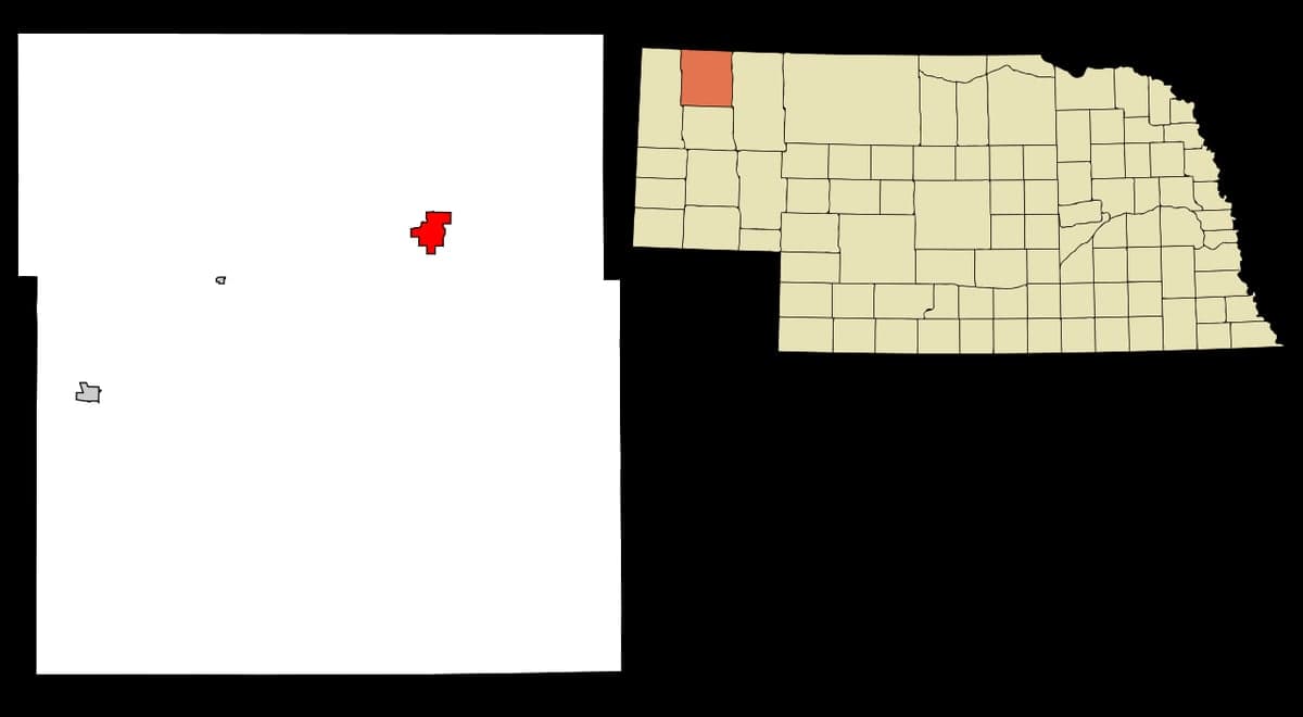
Strategic Assessment of Chadron, NE
Deep buffer from population centers and strategic targets. Low natural disaster risk and minimal exposure to border or coastal threats.
What does the Strategic Assessment tell us?
Our Strategic Assessment grades tactical survivability of an area. Major population centers, military targets, fallout zones, natural disasters, and border exposure all drive risk — lower exposure means a more defensible position in a crisis.
This is heavily inspired by Joel Skousen's Strategic Relocation book. Highly recommended you checkout the book ($)What does this tell us?
Our Strategic Assessment grades tactical survivability of an area. Major population centers, military targets, fallout zones, natural disasters, and border exposure all drive risk — lower exposure means a more defensible position in a crisis.
This is heavily inspired by Joel Skousen's Strategic Relocation book. Highly recommended you checkout the book ($)Strategic Pillars

Key Distances
Regional Safe Places
Below is our recommended "safe zones" in Nebraska and the surrounding area based on our strategic heuristics. For most people, it's unrealistic to live in a “safe zone” full-time due to work, family or other personal reasons. They tend to be more rural. However, many of these areas are perfect for second homes and retreat properties that double as a vacation home or even a short-term rental.
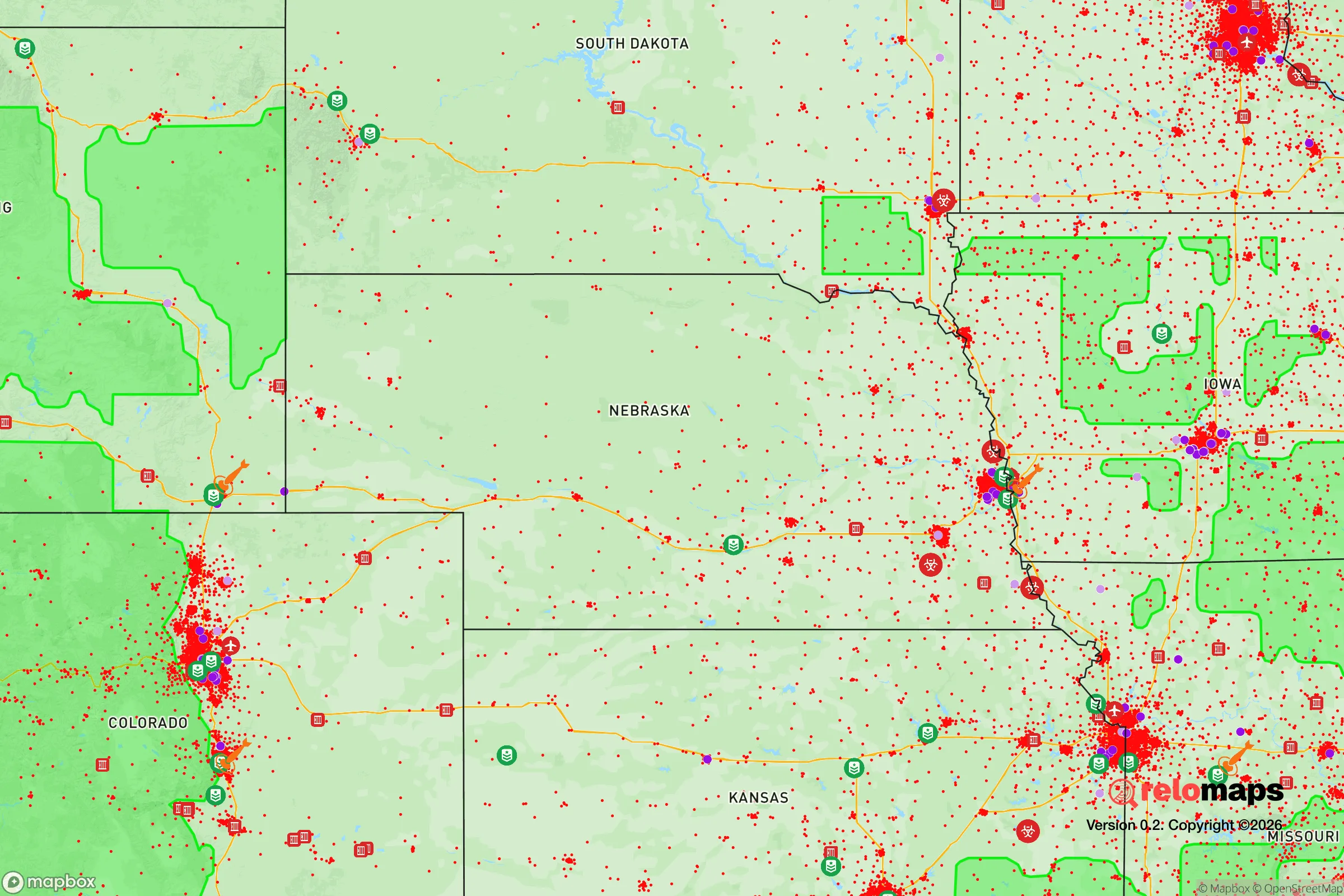
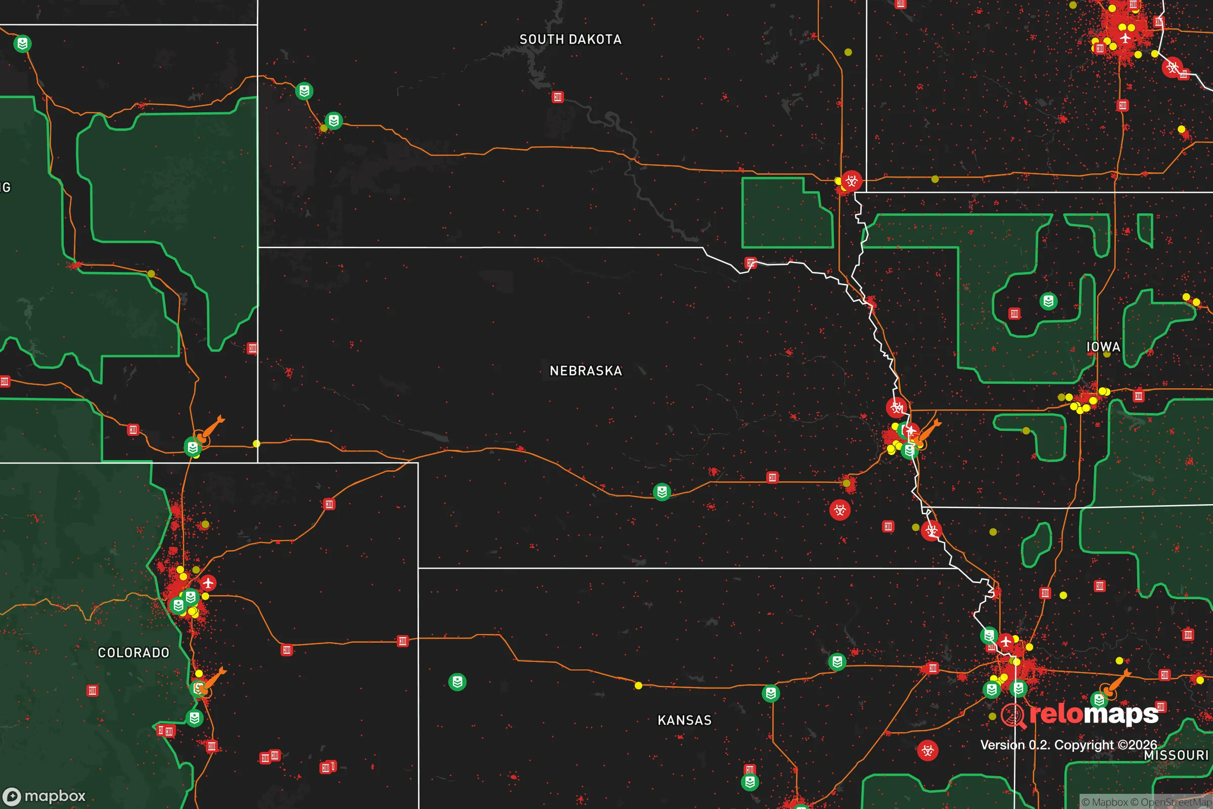
Important Note: For informational purposes only. This does not mean nothing bad ever happens in the green zones. Please use common sense. This is based on public data and modeled with AI. We tried to take a conservative approach but mistakes happen. We update this regularly as new information becomes available.
Solar Generator Recommendations
Backup power matters more here than in safer locations. We've picked three solar generators across budgets and capacity tiers — start with the budget unit if you only need a few essentials, or step up if you want to run a fridge and HVAC for days at a time.

Jackery Portable Power Station Explorer 300
Budget OptionPower on the Go: Weighing only 11 lbs, it's convenient to set up and store with book-sized foldable solar panels

BLUETTI Portable Power Station AC180
Designed for both indoor and outdoor scenarios, AC180 is highly capable as it has a robost capacity and continuous output power.

EF ECOFLOW DELTA Pro Ultra Power Station
Upgraded PickEcoFlow DELTA Pro Ultra is a whole-home energy system designed to grow with your family. Integrated with the Smart Home Panel 2, it scales to meet your evolving energy needs — keeping your home powered, intelligent, and secure through every stage of life.
We earn a commission, at no additional cost to you.
Strategic Assessment Analysis
Chadron, Nebraska, sits as a genuine outlier in the Great Plains—a small, hardscrabble town of roughly 5,200 people that offers a rare combination of geographic isolation, natural resource abundance, and low strategic vulnerability. For the conservative prepper or survivalist looking to get out of the blast radius of coastal population centers and the political chaos of the interior cities, Chadron presents a defensible, self-sufficient base of operations that most relocation analyses completely overlook. It’s not flashy, it’s not trendy, and that’s precisely the point.
Geographic isolation and natural defensive advantages of the Pine Ridge region
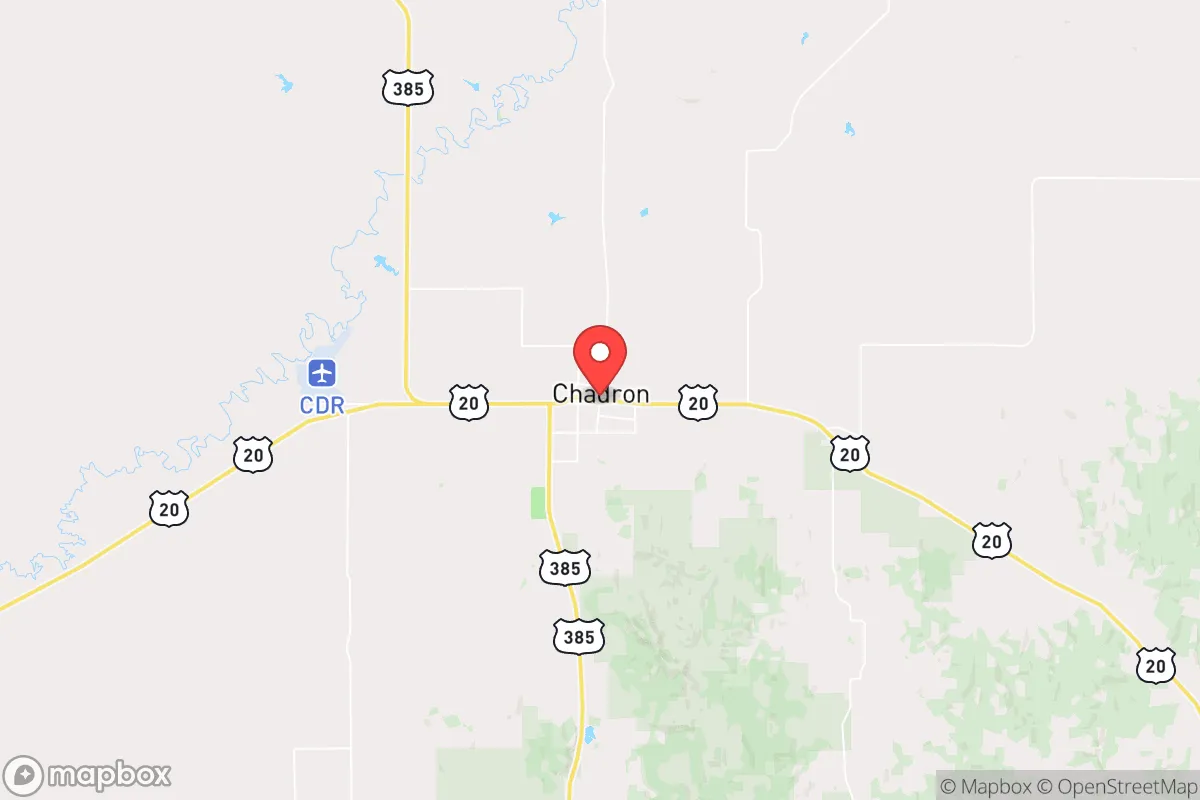
Chadron’s location in the far northwestern corner of Nebraska, hard against the South Dakota border, is its single greatest strategic asset. The town sits at the edge of the Pine Ridge escarpment, a rugged, forested uplift that breaks the monotony of the plains and provides natural cover, elevation, and water drainage that the flatlands to the east simply cannot offer. The surrounding Dawes County is among the least densely populated in the lower 48—roughly 4 people per square mile. That means your nearest neighbor is likely miles away, and the nearest significant population center (Rapid City, South Dakota) is 90 miles to the northwest. Scottsbluff, the next Nebraska town of any size, is 100 miles south. This isolation is a double-edged sword: it makes supply runs a chore, but it also means that if the grid goes down or civil unrest erupts in Denver or Omaha, Chadron will be one of the last places to feel the ripple effects. The Pine Ridge itself offers hundreds of square miles of public land (the Nebraska National Forest and the Oglala National Grassland) for hunting, foraging, and fallback positions. The terrain is hilly, broken, and difficult to navigate for anyone unfamiliar with it—a natural barrier against organized movement.
Fallout proximity, target risk, and exposure to national-level disruptions
From a nuclear or EMP perspective, Chadron is about as clean as it gets in the continental United States. The nearest major strategic target is Ellsworth Air Force Base near Rapid City, which houses B-1B bombers and is a high-priority first-strike target in any peer-level conflict. That’s 90 miles away—close enough to worry about fallout patterns if prevailing winds shift east or southeast, but far enough that a ground burst at Ellsworth would not directly destroy Chadron. The real concern is the Black Hills region itself, which contains multiple strategic assets: the Mount Rushmore communications node, the NORAD facility at Cheyenne Mountain (though that’s in Colorado, 300 miles southwest), and the Minuteman III missile silos scattered across western Nebraska and the Dakotas. Chadron sits within 50 miles of several active missile silos in the 90th Missile Wing’s area of responsibility. In a full-scale exchange, those silos are primary targets. However, because they are hardened and widely dispersed, the actual ground contamination from a single silo strike is localized. The bigger risk is fallout from a strike on Ellsworth or the silos themselves drifting over Chadron. Preppers should plan for at least two weeks of shelter-in-place capability with HEPA filtration and sealed rooms, and have a southward evacuation route toward the Sandhills (which have no strategic value) if winds are unfavorable. For EMP, Chadron’s isolation works in its favor: the power grid here is less interconnected than coastal systems, and the town’s reliance on groundwater wells and propane means a post-EMP recovery could be faster than in a city that depends on complex supply chains.
Practical resilience: food, water, energy, and defensibility for a relocator
Chadron’s practical resilience is where it truly shines for the serious prepper. Water is abundant and accessible: the town sits atop the Ogallala Aquifer, one of the largest freshwater aquifers in the world, and the local water table is high enough that shallow wells (50-100 feet) are common in the surrounding rural areas. The Chadron Creek and the White River drainage provide surface water, though treatment is necessary. For energy, the region has excellent wind resources, and solar is viable (though winter days are short). Propane is widely used for heating and cooking, and bulk delivery is available from several local suppliers. The town itself has a small but functional hospital (Chadron Community Hospital) and a regional airport with a 6,000-foot runway capable of handling cargo aircraft—useful if supply chains break down and you need to fly in supplies. Food production is the weak link: the growing season is short (roughly 120 days), and the soil is sandy and alkaline. You will not be growing corn or wheat here without serious amendment and irrigation. However, the surrounding ranchland supports cattle, bison, and elk, and hunting is excellent (deer, antelope, turkey, and small game). The Pine Ridge area also has a strong tradition of small-scale market gardening and greenhouse production, so with a hoophouse and some know-how, you can produce a surprising amount of vegetables. For defensibility, Chadron’s layout is compact—a few main streets, with residential areas spreading into the surrounding hills. The town is not easily approached from any direction without being seen, and the forested hills provide excellent cover for perimeter security. The local culture is heavily conservative, self-reliant, and armed; the county sheriff’s office is responsive, and the community is tight-knit. Outsiders who make an effort to integrate will find allies, not suspicion.
The overall strategic picture for Chadron is one of high isolation, moderate natural resource availability, and low target value—a combination that is increasingly rare in the lower 48. It is not a place for someone who needs urban amenities, diverse employment, or a vibrant social scene. But for the individual or family whose primary goal is to be out of the way, self-sufficient, and prepared for a long-term disruption of the national order, Chadron offers a defensible, water-secure, and community-aligned option that few other locations can match. The trade-offs are real: harsh winters, limited medical specialists, and a long drive to any major supply hub. But in a world where the major cities are becoming unlivable due to crime, political instability, and infrastructure decay, Chadron’s quiet remoteness looks less like a liability and more like a lifeline.
* Values derived from national, state, county, city and local statistics and may differ in a specific area. Last updated: 2026-05-03T20:31:57.000Z
Narrative content on this page is AI-generated and may contain mistakes. Verify any details that matter before acting on them.
ReloMaps may earn a commission from affiliate links at no extra cost to you.