

Photo: Wikipedia
Strategic Assessment of Chelsea, MA
High tactical risk. This location is likely close to major population centers, strategic targets, or sits in a high-disaster corridor. A retreat property and careful exit planning is required.
What does the Strategic Assessment tell us?
Our Strategic Assessment grades tactical survivability of an area. Major population centers, military targets, fallout zones, natural disasters, and border exposure all drive risk — lower exposure means a more defensible position in a crisis.
This is heavily inspired by Joel Skousen's Strategic Relocation book. Highly recommended you checkout the book ($)What does this tell us?
Our Strategic Assessment grades tactical survivability of an area. Major population centers, military targets, fallout zones, natural disasters, and border exposure all drive risk — lower exposure means a more defensible position in a crisis.
This is heavily inspired by Joel Skousen's Strategic Relocation book. Highly recommended you checkout the book ($)Strategic Pillars

Key Distances
Regional Safe Places
Below is our recommended "safe zones" in Massachusetts and the surrounding area based on our strategic heuristics. For most people, it's unrealistic to live in a “safe zone” full-time due to work, family or other personal reasons. They tend to be more rural. However, many of these areas are perfect for second homes and retreat properties that double as a vacation home or even a short-term rental.


Important Note: For informational purposes only. This does not mean nothing bad ever happens in the green zones. Please use common sense. This is based on public data and modeled with AI. We tried to take a conservative approach but mistakes happen. We update this regularly as new information becomes available.
Solar Generator Recommendations
Backup power matters more here than in safer locations. We've picked three solar generators across budgets and capacity tiers — start with the budget unit if you only need a few essentials, or step up if you want to run a fridge and HVAC for days at a time.

Jackery Portable Power Station Explorer 300
Budget OptionPower on the Go: Weighing only 11 lbs, it's convenient to set up and store with book-sized foldable solar panels

BLUETTI Portable Power Station AC180
Designed for both indoor and outdoor scenarios, AC180 is highly capable as it has a robost capacity and continuous output power.

EF ECOFLOW DELTA Pro Ultra Power Station
Upgraded PickEcoFlow DELTA Pro Ultra is a whole-home energy system designed to grow with your family. Integrated with the Smart Home Panel 2, it scales to meet your evolving energy needs — keeping your home powered, intelligent, and secure through every stage of life.
We earn a commission, at no additional cost to you.
Strategic Assessment Analysis
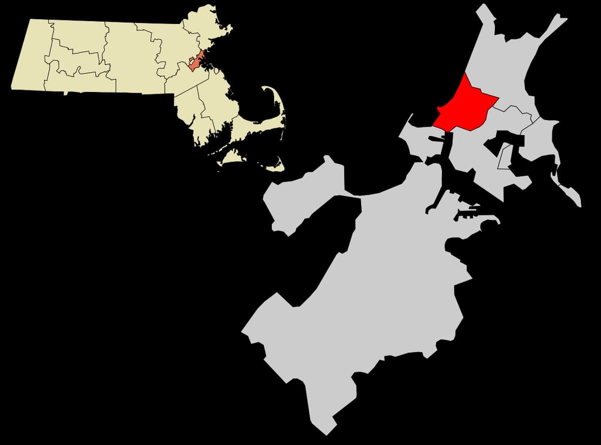
Chelsea, Massachusetts, sits in a precarious strategic position that demands serious consideration for anyone prioritizing long-term resilience. While its location offers immediate access to dense urban resources, the same geography that makes it convenient for daily life creates profound vulnerabilities in a crisis scenario. For the conservative-minded prepper or survivalist, Chelsea presents a mixed picture: proximity to Boston’s economic engine is offset by exposure to the risks that come with being a densely populated, infrastructure-dependent urban corridor. This assessment weighs those trade-offs with an eye toward civic unrest, mass casualty events, and disaster preparedness.
Geographic position and natural advantages for long-term survival
Chelsea occupies a roughly 2.5-square-mile peninsula on the Mystic River, directly across from Boston and adjacent to Everett and Revere. Its compact footprint means nearly everything is within walking distance—a potential advantage if fuel supplies are disrupted or roads become impassable. The city sits on relatively flat, low-lying land, which simplifies movement on foot but also exposes it to storm surge and flooding from the Mystic and Chelsea Creek. The area’s natural defenses are minimal: no significant elevation, no dense forests for cover, and no natural barriers to slow an approaching threat. The Chelsea River and Island End River provide some water access for fishing or small-boat evacuation, but these waterways are heavily industrialized and polluted, limiting their utility for sustainable food or water sourcing. The city’s position as a transportation hub—with Route 1, the Tobin Bridge, and the MBTA Commuter Rail—means it’s a natural chokepoint. In a crisis, those same arteries could become escape routes or, more likely, bottlenecks that trap residents. For a relocator, the lack of defensible terrain and the high population density (roughly 40,000 people in a few square miles) make Chelsea a poor choice for a primary retreat location. It’s better viewed as a potential staging area for short-term access to Boston’s resources before moving to a more secure inland position.
Risks, exposures, and proximity to fallout-relevant landmarks
Chelsea’s greatest strategic weakness is its proximity to high-value targets. The city lies within five miles of Boston Logan International Airport, the Port of Boston, and the Massachusetts State House—all potential focal points for civil unrest, terrorist attacks, or military action. The nearby Mystic Generating Station (a natural gas and oil-fired power plant) and the Chelsea Creek oil terminals are industrial hazards that could become secondary targets or sources of contamination. In a mass casualty event or large-scale disaster, Chelsea’s dense, multi-family housing stock and narrow streets would complicate evacuation and emergency response. The city’s population is also heavily dependent on public transit and food distribution networks—roughly 30% of households lack a vehicle, according to recent ACS data. That means a sudden disruption to supply chains or fuel availability could strand thousands. For the prepper, the risk of being caught in a crowd surge, riot, or secondary attack is real. The city’s location on the Mystic River also places it in a flood zone; a major storm or dam failure upstream could inundate low-lying neighborhoods within hours. While Chelsea itself is not a primary target, its role as a transit corridor and industrial hub makes it a likely zone of secondary chaos. The conservative survivalist should view this as a place to pass through, not to settle.
Practical resilience for a relocator: food, water, energy, and defensibility
For someone considering Chelsea as a base, the practical challenges are steep. The city’s water supply comes from the Massachusetts Water Resources Authority (MWRA), which draws from the Quabbin Reservoir—a system vulnerable to sabotage, contamination, or cyberattack. In a prolonged outage, Chelsea has no backup wells or natural springs; residents would rely on bottled water or rainwater collection, which is limited by the city’s dense, paved environment. Food options are decent for daily life—there are several supermarkets, bodegas, and ethnic markets along Broadway and the Chelsea Street corridor—but these stores operate on just-in-time delivery. A three-day supply chain disruption would empty shelves quickly. For long-term storage, Chelsea’s small lots and lack of basements in many older buildings make stockpiling difficult. Energy is another concern: the city is served by Eversource and National Grid, with no significant local solar or wind generation. A grid-down scenario would leave most residents without power for days or weeks. Defensibility is the weakest link. Chelsea’s street grid is a mix of narrow residential blocks and wide commercial avenues, offering few natural chokepoints for a small group to secure. The city’s high population density and ethnic diversity (over 60% Hispanic, with large Central American and Caribbean communities) mean that in a crisis, language barriers and cultural divisions could complicate mutual aid. For a single individual or family, the best resilience strategy in Chelsea is to maintain a low profile, keep a go-bag ready, and have a pre-planned evacuation route to a rural retreat in New Hampshire or western Massachusetts. The city itself is not defensible.
The overall strategic picture for Chelsea is one of calculated risk. Its location offers unmatched access to Boston’s medical, logistical, and economic resources during stable times, but those same advantages become liabilities when the system falters. For the conservative prepper, Chelsea is a place to monitor, not to invest in. The city’s density, flood risk, and proximity to high-value targets make it a likely zone of chaos in a major disaster or civil unrest event. A better approach is to use Chelsea as a temporary staging point—a place to gather supplies, coordinate with like-minded contacts, and then move to a more defensible inland location. If you’re already living there, the priority should be building a network of trusted neighbors, securing a vehicle with a full tank, and identifying multiple exit routes. In a world where the state’s ability to maintain order is uncertain, Chelsea’s strategic value is as a stepping stone, not a sanctuary.
* Values derived from national, state, county, city and local statistics and may differ in a specific area. Last updated: 2026-05-01T04:16:12.000Z
Narrative content on this page is AI-generated and may contain mistakes. Verify any details that matter before acting on them.
ReloMaps may earn a commission from affiliate links at no extra cost to you.