
Photo: Wikipedia
Strategic Assessment of Derby Line, VT
Meaningful friction. Expect exposure to either population pressure, blast zones, or natural disaster risk. Consider buying a retreat property.
What does the Strategic Assessment tell us?
Our Strategic Assessment grades tactical survivability of an area. Major population centers, military targets, fallout zones, natural disasters, and border exposure all drive risk — lower exposure means a more defensible position in a crisis.
This is heavily inspired by Joel Skousen's Strategic Relocation book. Highly recommended you checkout the book ($)What does this tell us?
Our Strategic Assessment grades tactical survivability of an area. Major population centers, military targets, fallout zones, natural disasters, and border exposure all drive risk — lower exposure means a more defensible position in a crisis.
This is heavily inspired by Joel Skousen's Strategic Relocation book. Highly recommended you checkout the book ($)Strategic Pillars

Key Distances
Regional Safe Places
Below is our recommended "safe zones" in Vermont and the surrounding area based on our strategic heuristics. For most people, it's unrealistic to live in a “safe zone” full-time due to work, family or other personal reasons. They tend to be more rural. However, many of these areas are perfect for second homes and retreat properties that double as a vacation home or even a short-term rental.


Important Note: For informational purposes only. This does not mean nothing bad ever happens in the green zones. Please use common sense. This is based on public data and modeled with AI. We tried to take a conservative approach but mistakes happen. We update this regularly as new information becomes available.
Solar Generator Recommendations
Backup power matters more here than in safer locations. We've picked three solar generators across budgets and capacity tiers — start with the budget unit if you only need a few essentials, or step up if you want to run a fridge and HVAC for days at a time.

Jackery Portable Power Station Explorer 300
Budget OptionPower on the Go: Weighing only 11 lbs, it's convenient to set up and store with book-sized foldable solar panels

BLUETTI Portable Power Station AC180
Designed for both indoor and outdoor scenarios, AC180 is highly capable as it has a robost capacity and continuous output power.

EF ECOFLOW DELTA Pro Ultra Power Station
Upgraded PickEcoFlow DELTA Pro Ultra is a whole-home energy system designed to grow with your family. Integrated with the Smart Home Panel 2, it scales to meet your evolving energy needs — keeping your home powered, intelligent, and secure through every stage of life.
We earn a commission, at no additional cost to you.
Strategic Assessment Analysis
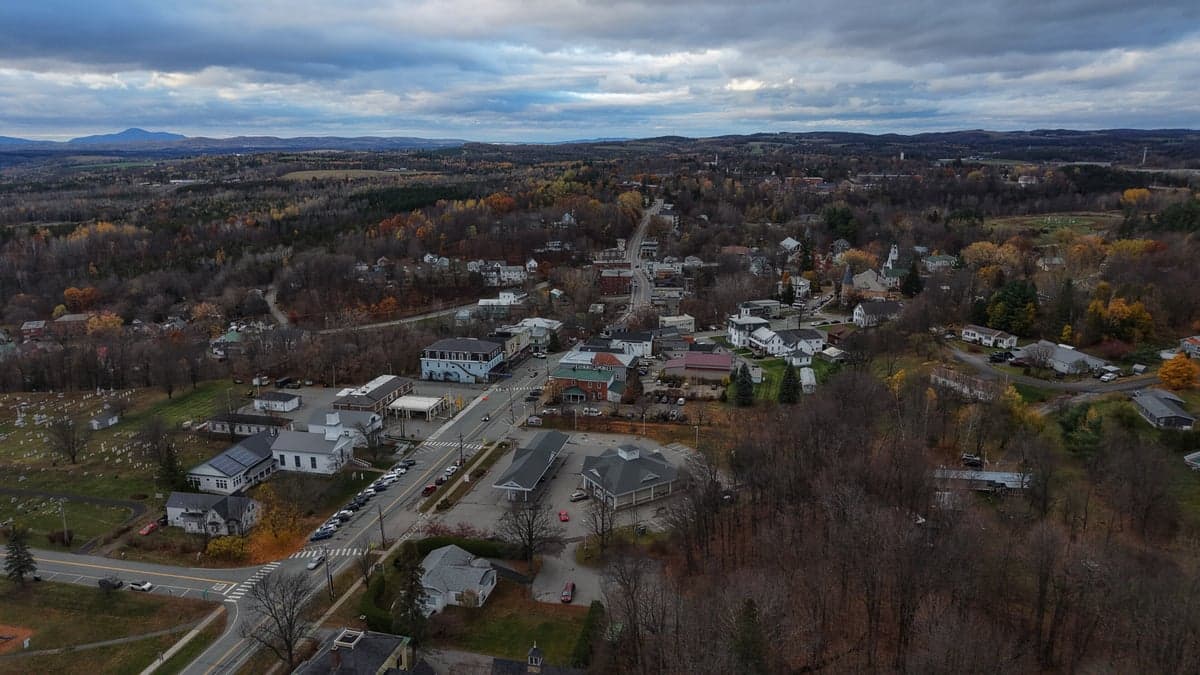
Derby Line, Vermont, offers a unique strategic proposition for those prioritizing resilience and distance from the chaos of urban collapse. Its location directly on the U.S.-Canada border provides a rare combination of isolation, a potential secondary jurisdiction for relocation, and a buffer from the worst of domestic unrest. For the conservative prepper or survivalist, this small town represents a hard-to-find blend of natural defensibility and practical escape options, though it comes with its own set of trade-offs in climate and supply chain access.
Geographic isolation and border advantages for long-term security
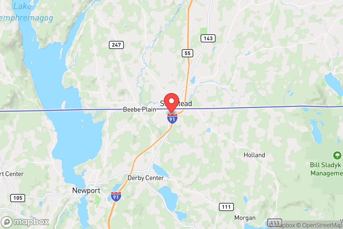
Derby Line’s primary strategic asset is its position at the northern terminus of Interstate 91, roughly 90 miles from Montreal and 120 miles from Burlington. This places it far from the major population corridors of the Eastern Seaboard—Boston, New York, and Washington D.C. are all over 300 miles away—meaning a collapse or mass casualty event in those cities would take days to ripple here, if at all. The town sits in Orleans County, a region with a population density of roughly 30 people per square mile, offering vast tracts of forest and farmland that serve as natural buffers. The border with Quebec is not just a line on a map; it provides a legal avenue for relocation or supply runs into Canada, a country with a different political trajectory and, for now, a more stable food and energy system. For the relocator, this dual-jurisdiction access is a hedge against federal overreach or localized tyranny—if things go south on one side, the other remains an option, provided you have the proper documentation and a plan for crossing.
Risks, exposures, and proximity to fallout-relevant landmarks
No location is without vulnerabilities, and Derby Line has several that demand attention. The most immediate risk is its proximity to the Canadian border itself—while this is an advantage, it also means the town sits within a high-traffic corridor for smuggling, illegal crossings, and potential federal law enforcement activity. In a crisis, the border could be sealed by either government, trapping residents or turning the area into a chokepoint. The nearby Interstate 91, while a lifeline, is also a vulnerability: in a mass evacuation scenario, it would become a clogged artery, and the town’s single main road (U.S. Route 5) offers limited egress. More concerning is the proximity to the Vermont Yankee nuclear plant in Vernon, about 150 miles south—well within the fallout zone of a catastrophic failure or a targeted attack. The plant is decommissioned but still holds spent fuel, a potential target for sabotage. Additionally, the town is within 200 miles of the Plattsburgh Air Force Base (now a civilian airport but still a strategic asset) and the Canadian Forces Base Valcartier near Quebec City, both of which could become targets in a conflict. For the survivalist, these are not deal-breakers but factors that require a layered defense plan—knowing wind patterns, having potassium iodide on hand, and maintaining a bug-out route north into the Canadian wilderness.
Practical resilience for a relocator: food, water, energy, and defensibility
Derby Line’s practical resilience hinges on its rural character and the self-sufficiency mindset of its residents. The town has a year-round population of around 700, meaning social cohesion is high and outsiders are noticed quickly—a double-edged sword for a relocator, but one that can be managed by building relationships early. Water is abundant: the town sits on the shores of Lake Memphremagog, a 30-mile-long glacial lake that straddles the border, providing a near-limitless source of fresh water. However, this water requires treatment or boiling, as agricultural runoff and septic seepage are concerns in the region. The lake also offers fishing and a potential transportation route, but it freezes solid from December to March, limiting its utility in winter. Food security is moderate: the growing season is short (roughly 100 days), and the soil is rocky and acidic, making large-scale gardening a challenge. Local farms produce dairy, maple syrup, and some vegetables, but the town relies heavily on supply chains from Burlington and Montreal. For the prepper, this means stockpiling non-perishables and investing in a greenhouse or hydroponic setup is non-negotiable. Energy is a bright spot: Vermont has a high rate of renewable energy adoption, and many homes in the area use wood stoves for heat—a critical advantage in a grid-down scenario. Solar panels are viable, though winter cloud cover reduces output significantly. Defensibility is excellent: the town is surrounded by dense forests and rolling hills, with few natural chokepoints but many concealed positions. The border itself acts as a psychological barrier—few would flee into Canada without a plan, and those who do are likely to be vetted by Canadian authorities. For a small group, the area can be held with minimal manpower, but the cold (average January highs of 22°F) is a weapon in itself, requiring serious cold-weather gear and training.
The overall strategic picture for a conservative relocator
Derby Line is not a bug-out location for the unprepared or the faint of heart. It is a hard, cold, and isolated place that rewards those who come with skills, supplies, and a clear-eyed understanding of its limitations. For the conservative prepper seeking to escape the urban decay, federal overreach, and societal unraveling of the lower 48, it offers a rare combination of natural barriers, border access, and a community that values self-reliance. The trade-offs are real: brutal winters, limited food production, and proximity to potential targets like the nuclear plant and border infrastructure. But in a world where mass casualty events, civil unrest, and government overreach are no longer hypotheticals, Derby Line stands as a viable redoubt—provided you treat it as a long-term investment, not a quick fix. The key is to arrive before the crisis, build relationships with locals, and have a plan for both sides of the border. If you can handle the cold and the isolation, this corner of Vermont might just be the safest place to wait out the storm.
* Values derived from national, state, county, city and local statistics and may differ in a specific area. Last updated: 2026-04-30T04:04:39.000Z
Narrative content on this page is AI-generated and may contain mistakes. Verify any details that matter before acting on them.
ReloMaps may earn a commission from affiliate links at no extra cost to you.