
Photo: Wikipedia
Strategic Assessment of Fort Thomas, KY
Multiple tactical vulnerabilities. Population density, target proximity, or disaster risk are likely compounding. A retreat property and exit planning is required.
What does the Strategic Assessment tell us?
Our Strategic Assessment grades tactical survivability of an area. Major population centers, military targets, fallout zones, natural disasters, and border exposure all drive risk — lower exposure means a more defensible position in a crisis.
This is heavily inspired by Joel Skousen's Strategic Relocation book. Highly recommended you checkout the book ($)What does this tell us?
Our Strategic Assessment grades tactical survivability of an area. Major population centers, military targets, fallout zones, natural disasters, and border exposure all drive risk — lower exposure means a more defensible position in a crisis.
This is heavily inspired by Joel Skousen's Strategic Relocation book. Highly recommended you checkout the book ($)Strategic Pillars

Key Distances
Regional Safe Places
Below is our recommended "safe zones" in Kentucky and the surrounding area based on our strategic heuristics. For most people, it's unrealistic to live in a “safe zone” full-time due to work, family or other personal reasons. They tend to be more rural. However, many of these areas are perfect for second homes and retreat properties that double as a vacation home or even a short-term rental.


Important Note: For informational purposes only. This does not mean nothing bad ever happens in the green zones. Please use common sense. This is based on public data and modeled with AI. We tried to take a conservative approach but mistakes happen. We update this regularly as new information becomes available.
Solar Generator Recommendations
Backup power matters more here than in safer locations. We've picked three solar generators across budgets and capacity tiers — start with the budget unit if you only need a few essentials, or step up if you want to run a fridge and HVAC for days at a time.

Jackery Portable Power Station Explorer 300
Budget OptionPower on the Go: Weighing only 11 lbs, it's convenient to set up and store with book-sized foldable solar panels

BLUETTI Portable Power Station AC180
Designed for both indoor and outdoor scenarios, AC180 is highly capable as it has a robost capacity and continuous output power.

EF ECOFLOW DELTA Pro Ultra Power Station
Upgraded PickEcoFlow DELTA Pro Ultra is a whole-home energy system designed to grow with your family. Integrated with the Smart Home Panel 2, it scales to meet your evolving energy needs — keeping your home powered, intelligent, and secure through every stage of life.
We earn a commission, at no additional cost to you.
Strategic Assessment Analysis
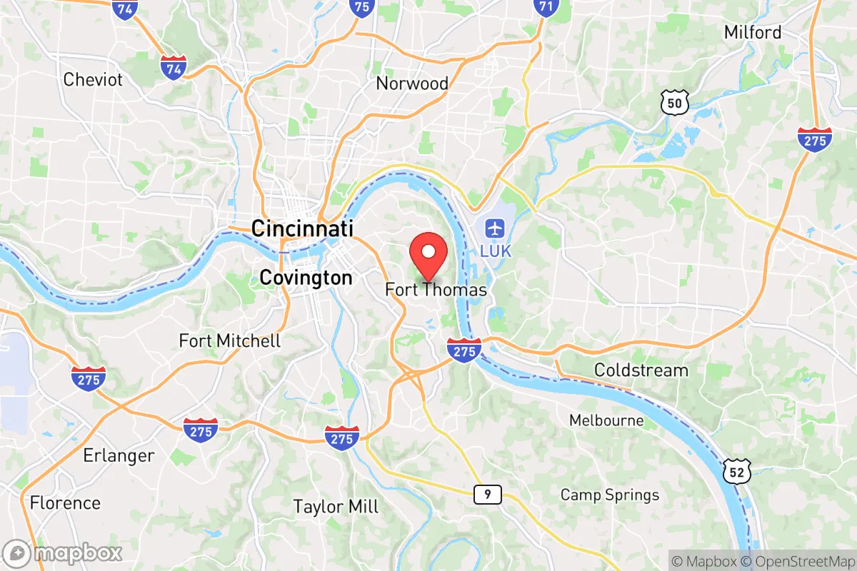
Fort Thomas, Kentucky, presents a mixed bag for the strategic relocator. Its position on the Ohio River, directly across from Cincinnati, offers immediate access to regional resources, but that same proximity to a major metropolitan hub introduces significant vulnerabilities that a prepper cannot ignore. The city’s historic, walkable neighborhoods and strong local governance provide a veneer of stability, but beneath that lies a complex risk profile that demands careful, unvarnished assessment. For the conservative-minded individual or family looking to balance preparedness with a functional, community-oriented lifestyle, Fort Thomas is a location that requires a clear-eyed understanding of both its defensive strengths and its exposure to cascading failures.
Geographic position and natural advantages for long-term stability
Fort Thomas sits atop a series of steep hills overlooking the Ohio River, a natural elevation that provides a modest defensive advantage against both floodwaters and ground-level unrest. The city’s topography—characterized by ridges and valleys—creates natural chokepoints on its main arteries (US-27, KY-8, and I-471), which could be leveraged for neighborhood-level security in a grid-down scenario. The surrounding region, part of the Outer Bluegrass region, offers decent soil for small-scale agriculture, though it is not the rich farmland of central Kentucky. Water access is a double-edged sword: the Ohio River is a massive, reliable water source, but it is also a heavily trafficked industrial corridor and a potential target for sabotage or contamination. The area’s temperate climate with four distinct seasons reduces the risk of extreme weather events compared to the Gulf Coast or Tornado Alley, though winter ice storms and occasional severe thunderstorms are routine. For a relocator, the key natural advantage is the abundance of nearby state parks and forested areas (like the Daniel Boone National Forest, about 90 minutes south) that could serve as bug-out locations or resource caches, but the immediate suburban environment offers limited wilderness for long-term self-sufficiency.
Risks, exposures, and proximity to high-value fallout targets
The single greatest vulnerability for Fort Thomas is its location within the Cincinnati metropolitan area. The city is roughly 5 miles from downtown Cincinnati, placing it well within the blast and fallout zone of any major attack on that city’s infrastructure—including the Brent Spence Bridge (a critical interstate chokepoint), the Cincinnati/Northern Kentucky International Airport (CVG), and the numerous chemical plants and rail yards along the Ohio River. A mass casualty event or EMP strike targeting the region would likely render Fort Thomas a dead zone for weeks, with refugees pouring across the river from Ohio. The city itself is not a primary target, but its proximity to I-71/75, a major north-south logistics corridor, makes it a natural funnel for displaced populations. Additionally, the nearby Cincinnati Water Works and the Miller Brewing plant (both on the river) are potential targets for contamination or sabotage. For the prepper, the risk of being caught in a secondary wave of violence or resource competition from fleeing urban populations is high. The city’s dense, interconnected suburban layout—with narrow streets and limited egress routes—could become a trap if civil unrest spreads from the urban core. The presence of multiple hospitals (St. Elizabeth Fort Thomas, Cincinnati Children’s) is a double-edged sword: they are assets for medical care but also potential magnets for desperate crowds during a crisis.
Practical resilience for a relocator: food, water, energy, and defensibility
For a family or individual looking to establish a resilient household, Fort Thomas requires significant upfront investment. The city’s water supply comes from the Ohio River via the Greater Cincinnati Water Works, which is vulnerable to both upstream contamination and infrastructure failure. A prepper should plan for a minimum of two weeks of stored water per person, plus a Berkey or similar gravity filter for river water. The local power grid is tied to Duke Energy’s regional system, which has a mixed reliability record during storms; a whole-house generator with a buried propane tank is a near-necessity for anyone serious about continuity. Food resilience is limited: the city has a handful of small grocery stores (Kroger, Aldi) but no significant local food production. Community gardens exist but are small-scale. A relocator would need to establish relationships with farmers in surrounding Campbell County or across the river in Ohio for bulk purchases of grains, meats, and canned goods. Defensibility is the weak point. Fort Thomas is a dense, walkable suburb with many historic homes on small lots. While the hills provide some natural cover, the lack of rural acreage means a prepper cannot easily create a perimeter or maintain livestock. The city’s police force is professional but small (roughly 30 officers), and in a prolonged crisis, residents would largely be on their own. The best strategy for a relocator here is to treat Fort Thomas as a “base camp” rather than a final redoubt—a place to build community ties, store supplies, and monitor events, with a pre-planned bug-out route to more rural areas in southern Kentucky or West Virginia.
The overall strategic picture for Fort Thomas is one of calculated risk. It offers a strong sense of community, good schools, and a relatively stable local government—factors that appeal to conservative families seeking a normal life with a preparedness edge. But the city’s location within the Cincinnati orbit means it cannot escape the fallout of a major national crisis. For the single individual or parent who is willing to invest in robust home infrastructure (water storage, power backup, security systems) and maintain a low profile, Fort Thomas can work as a forward operating location. However, for those seeking true rural self-sufficiency or a location far from population centers and critical infrastructure targets, this area falls short. The wise relocator will view Fort Thomas as a stepping stone—a place to build skills and networks while keeping one eye on the exit. If you can accept the trade-offs and plan accordingly, it is a defensible choice in an otherwise vulnerable region. If not, look further south, past the I-64 corridor, where the hills get steeper and the cities get smaller.
* Values derived from national, state, county, city and local statistics and may differ in a specific area. Last updated: 2026-04-21T10:44:03.000Z
Narrative content on this page is AI-generated and may contain mistakes. Verify any details that matter before acting on them.
ReloMaps may earn a commission from affiliate links at no extra cost to you.