
Photo: Wikipedia
Strategic Assessment of Frankfort, KY
Meaningful friction. Expect exposure to either population pressure, blast zones, or natural disaster risk. Consider buying a retreat property.
What does the Strategic Assessment tell us?
Our Strategic Assessment grades tactical survivability of an area. Major population centers, military targets, fallout zones, natural disasters, and border exposure all drive risk — lower exposure means a more defensible position in a crisis.
This is heavily inspired by Joel Skousen's Strategic Relocation book. Highly recommended you checkout the book ($)What does this tell us?
Our Strategic Assessment grades tactical survivability of an area. Major population centers, military targets, fallout zones, natural disasters, and border exposure all drive risk — lower exposure means a more defensible position in a crisis.
This is heavily inspired by Joel Skousen's Strategic Relocation book. Highly recommended you checkout the book ($)Strategic Pillars

Key Distances
Regional Safe Places
Below is our recommended "safe zones" in Kentucky and the surrounding area based on our strategic heuristics. For most people, it's unrealistic to live in a “safe zone” full-time due to work, family or other personal reasons. They tend to be more rural. However, many of these areas are perfect for second homes and retreat properties that double as a vacation home or even a short-term rental.


Important Note: For informational purposes only. This does not mean nothing bad ever happens in the green zones. Please use common sense. This is based on public data and modeled with AI. We tried to take a conservative approach but mistakes happen. We update this regularly as new information becomes available.
Solar Generator Recommendations
Backup power matters more here than in safer locations. We've picked three solar generators across budgets and capacity tiers — start with the budget unit if you only need a few essentials, or step up if you want to run a fridge and HVAC for days at a time.

Jackery Portable Power Station Explorer 300
Budget OptionPower on the Go: Weighing only 11 lbs, it's convenient to set up and store with book-sized foldable solar panels

BLUETTI Portable Power Station AC180
Designed for both indoor and outdoor scenarios, AC180 is highly capable as it has a robost capacity and continuous output power.

EF ECOFLOW DELTA Pro Ultra Power Station
Upgraded PickEcoFlow DELTA Pro Ultra is a whole-home energy system designed to grow with your family. Integrated with the Smart Home Panel 2, it scales to meet your evolving energy needs — keeping your home powered, intelligent, and secure through every stage of life.
We earn a commission, at no additional cost to you.
Strategic Assessment Analysis
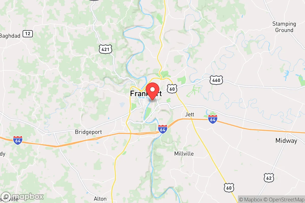
Frankfort, Kentucky, occupies a strategic sweet spot that resilience-minded relocators should take seriously: it sits within a day's drive of over half the U.S. population yet remains small enough (population roughly 28,000) to avoid the chaos vectors of major metros. The city's position along the Kentucky River, its status as a state capital with inherent governance infrastructure, and its location in the Bluegrass region—away from major fault lines, hurricane zones, and coastal flood risks—give it a baseline survivability that many Mid-South towns lack. For someone weighing long-term stability against the backdrop of increasing civic unrest and potential mass casualty events, Frankfort offers a rare combination of isolation from primary targets and access to critical resources.
Geographic position and natural advantages for long-term stability
Frankfort's geography is its first line of defense. The city is nestled in the rolling hills of north-central Kentucky, roughly 50 miles east of Louisville and 30 miles west of Lexington—close enough to tap those economies for supply runs or medical care, but far enough that a major event in either city would not automatically spill over. The Kentucky River cuts through the heart of Frankfort, providing a reliable freshwater source that is less prone to contamination than surface reservoirs near industrial corridors. The surrounding terrain is a mix of limestone bedrock, hardwood forests, and agricultural land, which means decent groundwater recharge and ample hunting potential if supply chains falter. The area sits in USDA hardiness zone 6b, with a growing season long enough for serious gardening but winters cold enough to suppress pest-borne diseases. Critically, Frankfort is outside the 50-mile blast radius of any major military installation or nuclear power plant—the nearest reactor is at the now-decommissioned Blue Grass Army Depot site, which is being converted to conventional munitions storage. The city's elevation (roughly 500 feet above sea level) and inland position mean it is virtually immune to storm surge, and tornado risk, while present, is lower than in the Plains or Deep South.
Risks, exposures, and proximity to fallout-relevant landmarks
No location is without vulnerabilities, and Frankfort has a few that a prepper must account for. The most significant is the Blue Grass Army Depot, located about 10 miles southeast of downtown. This facility stores conventional munitions and, until recently, held chemical weapons stockpiles (the last of which were destroyed in 2023). While the chemical weapons are gone, the depot remains a potential target for sabotage or accidental explosion—a worst-case scenario could produce a fragmentation hazard over a several-mile radius. Additionally, Frankfort is within 100 miles of the Fort Knox gold depository and the Louisville International Airport, both of which could become focal points during a currency collapse or mass evacuation scenario. The city's status as the state capital means it hosts the Kentucky State Capitol, the Governor's Mansion, and various federal offices—symbolic targets that could attract protest activity or, in a severe breakdown, direct action. The Kentucky River, while a water asset, also poses a flood risk: the downtown area has experienced moderate flooding in high-rain years, and the river's narrow valley can channel stormwater quickly. Finally, Frankfort sits near the intersection of I-64 and US-127, two major evacuation routes that could become clogged during a regional crisis, potentially turning the city into a chokepoint rather than a sanctuary.
Practical resilience for a relocator: food, water, energy, and defensibility
For someone serious about self-sufficiency, Frankfort's practical infrastructure is a mixed bag with strong upside. Water: The Kentucky River is the primary municipal source, but the city also draws from groundwater wells in the surrounding karst aquifer. A private well on rural property within 15 miles of town can yield 10-20 gallons per minute at depths of 100-300 feet—viable for a household with proper filtration. The river itself is navigable by small craft, offering a secondary transport route if roads are compromised. Food: Franklin County has roughly 600 farms, many of them small-scale operations producing beef, poultry, corn, and soybeans. The local farmers' market operates year-round, and the Kentucky Department of Agriculture maintains a seed bank in Frankfort. For long-term storage, the area's moderate humidity (averaging 70%) is manageable with proper drying and sealing. Energy: The grid is served by Kentucky Utilities, which relies heavily on coal and natural gas—vulnerable to both supply disruptions and cyberattacks. However, the rolling terrain offers excellent solar exposure for off-grid panels, and the abundant hardwood forests provide a sustainable fuel source for wood stoves. Defensibility: The city's layout is compact, with a historic downtown that narrows to a few bridge crossings over the Kentucky River—a natural defensive chokepoint. The surrounding hills provide vantage points for observation, and the rural-urban interface means a relocator can live on 5-10 acres within a 10-minute drive of grocery stores and medical clinics. The local law enforcement presence is modest (Frankfort Police Department has about 50 sworn officers), but the Kentucky State Police headquarters is located in the city, providing a rapid-response asset that would likely remain operational during most scenarios.
The overall strategic picture for Frankfort is one of calculated viability. It is not a remote bunker—it is a working capital city with the attendant risks of symbolic targets and population density (roughly 1,100 people per square mile in the city proper, dropping to under 100 in the surrounding county). But for a relocator who values proximity to government infrastructure, medical resources, and agricultural land over absolute isolation, Frankfort offers a balance that few other state capitals can match. The key is to buy property on the south or east sides of the river, away from the depot and the major highway corridors, and to invest in well water, solar backup, and a reliable means of river transport. In a world where the next crisis could be economic, epidemiological, or kinetic, Frankfort gives you a fighting chance to ride it out without having to disappear into the wilderness entirely.
* Values derived from national, state, county, city and local statistics and may differ in a specific area. Last updated: 2026-04-21T09:13:12.000Z
Narrative content on this page is AI-generated and may contain mistakes. Verify any details that matter before acting on them.
ReloMaps may earn a commission from affiliate links at no extra cost to you.