Photo: Wikipedia
Strategic Assessment of Gladstone, MO
Multiple tactical vulnerabilities. Population density, target proximity, or disaster risk are likely compounding. A retreat property and exit planning is required.
What does the Strategic Assessment tell us?
Our Strategic Assessment grades tactical survivability of an area. Major population centers, military targets, fallout zones, natural disasters, and border exposure all drive risk — lower exposure means a more defensible position in a crisis.
This is heavily inspired by Joel Skousen's Strategic Relocation book. Highly recommended you checkout the book ($)What does this tell us?
Our Strategic Assessment grades tactical survivability of an area. Major population centers, military targets, fallout zones, natural disasters, and border exposure all drive risk — lower exposure means a more defensible position in a crisis.
This is heavily inspired by Joel Skousen's Strategic Relocation book. Highly recommended you checkout the book ($)Strategic Pillars

Key Distances
Regional Safe Places
Below is our recommended "safe zones" in Missouri and the surrounding area based on our strategic heuristics. For most people, it's unrealistic to live in a “safe zone” full-time due to work, family or other personal reasons. They tend to be more rural. However, many of these areas are perfect for second homes and retreat properties that double as a vacation home or even a short-term rental.


Important Note: For informational purposes only. This does not mean nothing bad ever happens in the green zones. Please use common sense. This is based on public data and modeled with AI. We tried to take a conservative approach but mistakes happen. We update this regularly as new information becomes available.
Solar Generator Recommendations
Backup power matters more here than in safer locations. We've picked three solar generators across budgets and capacity tiers — start with the budget unit if you only need a few essentials, or step up if you want to run a fridge and HVAC for days at a time.

Jackery Portable Power Station Explorer 300
Budget OptionPower on the Go: Weighing only 11 lbs, it's convenient to set up and store with book-sized foldable solar panels

BLUETTI Portable Power Station AC180
Designed for both indoor and outdoor scenarios, AC180 is highly capable as it has a robost capacity and continuous output power.

EF ECOFLOW DELTA Pro Ultra Power Station
Upgraded PickEcoFlow DELTA Pro Ultra is a whole-home energy system designed to grow with your family. Integrated with the Smart Home Panel 2, it scales to meet your evolving energy needs — keeping your home powered, intelligent, and secure through every stage of life.
We earn a commission, at no additional cost to you.
Strategic Assessment Analysis
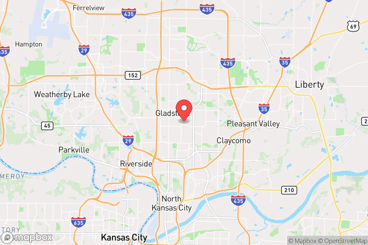
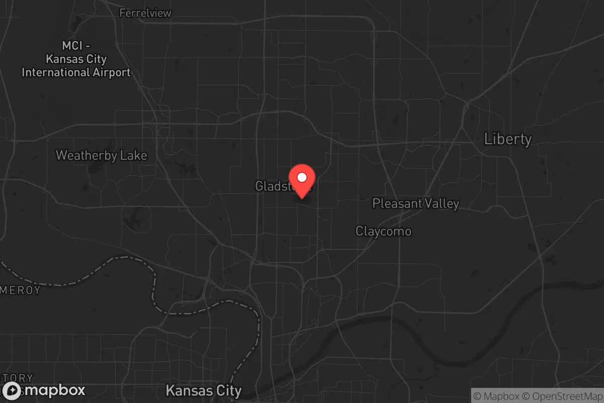
Gladstone, Missouri, sits in a strategic sweet spot that resilience-minded relocators should not overlook: close enough to Kansas City’s infrastructure to be practical, yet far enough to avoid the worst of urban chaos when things go sideways. The city’s position in Clay County offers a blend of suburban stability and rural adjacency that makes it viable for long-term self-sufficiency, especially for those who want to maintain professional ties to the metro while keeping a foot in more defensible territory. For a conservative audience weighing civic unrest, supply-chain disruptions, and mass-casualty scenarios, Gladstone presents a calculated trade-off—not a bunker, but a solid base camp with options.
Geographic position and natural advantages for long-term stability
Gladstone’s location on the bluffs above the Missouri River gives it a natural elevation advantage over flood-prone areas downstream, a detail that matters when considering climate-related displacement or infrastructure failures. The city sits roughly 10 miles north of downtown Kansas City, placing it outside the immediate blast radius of any hypothetical high-value target in the urban core, yet within a 20-minute drive for resupply or medical access during stable periods. The surrounding Clay County landscape is rolling hills and mixed hardwood forest, offering decent cover and multiple egress routes via U.S. Route 69, Interstate 35, and Missouri Route 152—critical for bug-out scenarios or supply runs when main arteries clog. The proximity to the Missouri River also means access to a major freshwater source, though relocators should note that river water requires filtration and treatment before use. The area’s moderate climate, with four distinct seasons and average annual rainfall around 38 inches, supports small-scale agriculture and rainwater catchment without the extremes of drought-prone regions. For a prepper household, this means a longer growing season than the northern plains and fewer wildfire risks than the West, making Gladstone a viable spot for establishing a semi-self-reliant homestead within commuting distance of a major job market.
Risks, exposures, and proximity to fallout-relevant landmarks
No strategic assessment is honest without naming the liabilities. Gladstone’s primary exposure comes from its proximity to Kansas City’s critical infrastructure: the city lies roughly 12 miles from the Kansas City International Airport (MCI), a major cargo and passenger hub that could become a secondary target or a chokepoint during a national emergency. The nearby BNSF and Union Pacific rail yards, which move hazardous materials through the metro, add another layer of risk—derailments or sabotage could release toxic chemicals into the air or water table. On the military side, Whiteman Air Force Base (home to the B-2 Spirit bomber) is about 60 miles southeast, placing Gladstone outside the primary blast zone but within the fallout plume radius of a ground-level nuclear strike on that facility. The Truman Reservoir and the Missouri River dams upstream are also worth monitoring; a coordinated attack or catastrophic failure could send floodwaters down the Missouri Valley, though Gladstone’s elevation largely mitigates that threat. For the conservative prepper, the biggest day-to-day risk is civil unrest spilling out of Kansas City proper—the 2020 riots demonstrated how quickly looting and arson can spread along the I-35 corridor. Gladstone’s police department is well-funded relative to its size (around 40 sworn officers for 27,000 residents), but during a widespread breakdown, the city’s grid layout and multiple entry points make it harder to seal off than a rural enclave. Relocators should plan for neighborhood-level security rather than relying on perimeter defense.
Practical resilience for a relocator: food, water, energy, and defensibility
For a single individual or family looking to harden their position, Gladstone offers a mixed bag. The city’s water supply comes from the Missouri River via Kansas City’s treatment system, which means any disruption to the metro’s power grid or chemical supply chain will cut municipal water within hours. A well is not standard in most Gladstone subdivisions—the area relies on city water and sewer—so preppers should budget for a 1,500-gallon cistern or a rainwater catchment system tied to gutter downspouts. The clay soil drains poorly, but raised beds and hoop houses can yield vegetables from April through October. Local zoning allows backyard chickens and small livestock in most residential lots, though pigs and cattle are restricted to agricultural parcels outside city limits. Energy resilience is achievable: net metering is available through Evergy (the local utility), and solar installers are active in the Northland, though homeowners associations in some subdivisions may restrict panel placement. Natural gas is the primary heating fuel, so a backup propane tank and a wood-burning stove are wise additions. Defensibility is the weak point—most Gladstone homes sit on standard suburban lots with open sightlines from the street and neighbors within 50 feet. A relocator serious about security should prioritize a corner lot with fenced backyard, reinforce entry doors, and establish a neighborhood watch or mutual-aid group with like-minded residents. The Clay County Sheriff’s Office has a strong reputation among conservative locals, but during a prolonged emergency, response times will stretch to hours or days. Stockpiling 90 days of food, water, and medical supplies is the baseline here, not paranoia.
The overall strategic picture for Gladstone is one of calculated compromise. It offers the economic stability of a Kansas City suburb—decent schools, a growing job base in healthcare and logistics, and a tax burden that is moderate by Missouri standards—while still being within a 30-minute drive of rural acreage in Platte or Clinton County for a secondary retreat. For the conservative relocator who wants to maintain a professional career while building resilience, Gladstone works as a primary residence if you treat it as a staging ground rather than a final redoubt. The city’s biggest advantage is its position: far enough from the urban core to dodge the worst of a collapse, close enough to tap into resources when times are stable. The biggest risk is complacency—it’s easy to feel safe here, but the same highways that bring Amazon packages can bring chaos. If you’re willing to invest in water independence, neighborhood security, and a bug-out plan for the rural fringe, Gladstone is a solid bet. If you’re looking for a remote off-grid compound, keep driving north another hour.
* Values derived from national, state, county, city and local statistics and may differ in a specific area. Last updated: 2026-04-30T12:46:26.000Z
Narrative content on this page is AI-generated and may contain mistakes. Verify any details that matter before acting on them.
ReloMaps may earn a commission from affiliate links at no extra cost to you.