Strategic Assessment of Glen Dale, WV
Meaningful friction. Expect exposure to either population pressure, blast zones, or natural disaster risk. Consider buying a retreat property.
What does the Strategic Assessment tell us?
Our Strategic Assessment grades tactical survivability of an area. Major population centers, military targets, fallout zones, natural disasters, and border exposure all drive risk — lower exposure means a more defensible position in a crisis.
This is heavily inspired by Joel Skousen's Strategic Relocation book. Highly recommended you checkout the book ($)What does this tell us?
Our Strategic Assessment grades tactical survivability of an area. Major population centers, military targets, fallout zones, natural disasters, and border exposure all drive risk — lower exposure means a more defensible position in a crisis.
This is heavily inspired by Joel Skousen's Strategic Relocation book. Highly recommended you checkout the book ($)Strategic Pillars

Key Distances
Regional Safe Places
Below is our recommended "safe zones" in West Virginia and the surrounding area based on our strategic heuristics. For most people, it's unrealistic to live in a “safe zone” full-time due to work, family or other personal reasons. They tend to be more rural. However, many of these areas are perfect for second homes and retreat properties that double as a vacation home or even a short-term rental.


Important Note: For informational purposes only. This does not mean nothing bad ever happens in the green zones. Please use common sense. This is based on public data and modeled with AI. We tried to take a conservative approach but mistakes happen. We update this regularly as new information becomes available.
Solar Generator Recommendations
Backup power matters more here than in safer locations. We've picked three solar generators across budgets and capacity tiers — start with the budget unit if you only need a few essentials, or step up if you want to run a fridge and HVAC for days at a time.

Jackery Portable Power Station Explorer 300
Budget OptionPower on the Go: Weighing only 11 lbs, it's convenient to set up and store with book-sized foldable solar panels

BLUETTI Portable Power Station AC180
Designed for both indoor and outdoor scenarios, AC180 is highly capable as it has a robost capacity and continuous output power.

EF ECOFLOW DELTA Pro Ultra Power Station
Upgraded PickEcoFlow DELTA Pro Ultra is a whole-home energy system designed to grow with your family. Integrated with the Smart Home Panel 2, it scales to meet your evolving energy needs — keeping your home powered, intelligent, and secure through every stage of life.
We earn a commission, at no additional cost to you.
Strategic Assessment Analysis
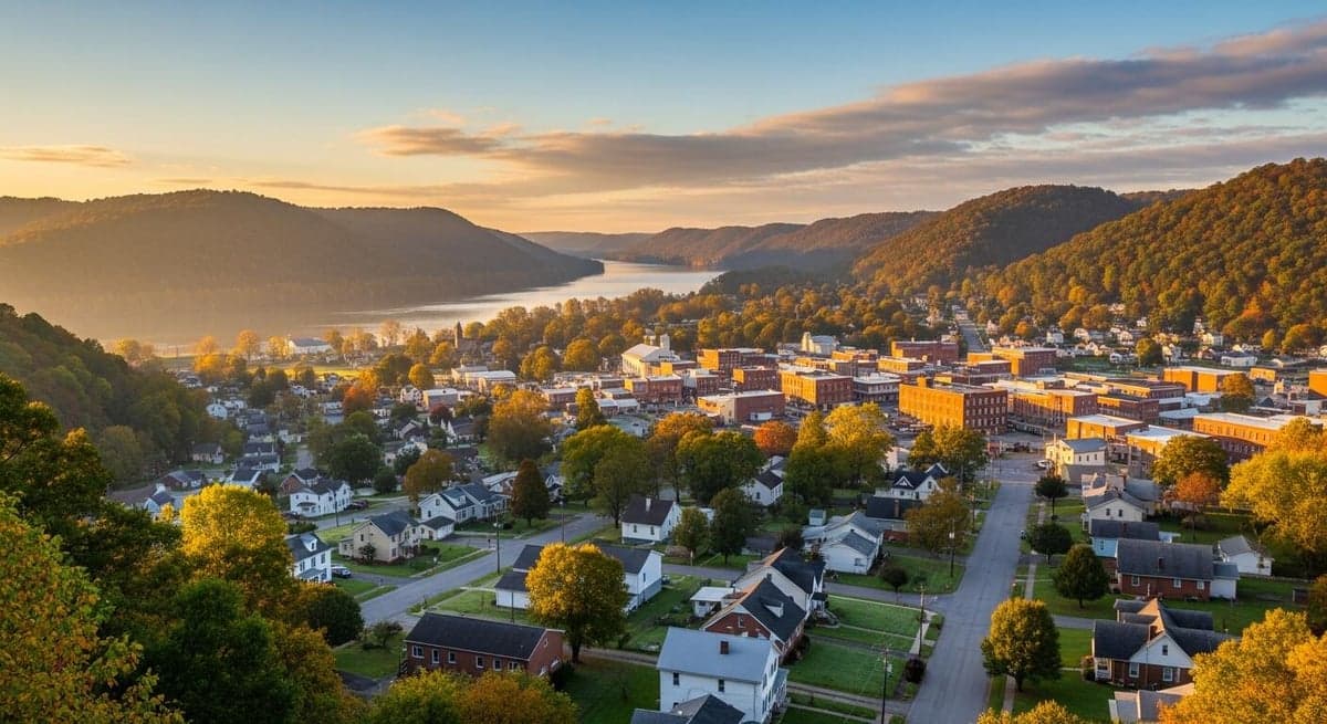
Glen Dale, West Virginia, sits in a narrow band of the Ohio River Valley that offers a surprisingly resilient strategic position for those thinking long-term about security and self-sufficiency. This small town in Marshall County, roughly 60 miles southwest of Pittsburgh and 90 miles west of Washington, D.C., benefits from being just far enough from major population centers to avoid the worst of urban collapse scenarios, yet close enough to access critical supply routes if they remain open. The area’s historical role as a manufacturing and transportation hub, combined with its position in the Appalachian foothills, gives it a layered defensive profile that warrants serious consideration for anyone evaluating relocation options in an unstable national climate.
Geographic position and natural defensive advantages
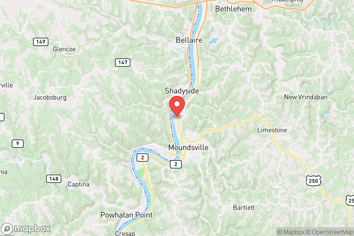
Glen Dale’s location along the Ohio River provides both a natural barrier and a strategic water resource, but it’s the surrounding topography that truly matters for resilience. The town sits on the eastern bank of the Ohio, with the river acting as a moat-like feature that complicates approach from the west. To the east and south, the rolling hills of the Appalachian Plateau rise quickly, creating natural chokepoints and elevated vantage points that would be difficult for any disorganized force to navigate. The area is part of the broader Northern Panhandle region, which is characterized by narrow valleys and steep ridges—terrain that inherently limits large-scale movement and favors defenders. For a relocator, this means that even a modest property with a clear line of sight to the river and the main roads (like WV-2 and I-70) can provide early warning and defensible space. The local climate is temperate, with four distinct seasons, but the hills offer some protection from the worst of winter winds, and the river moderates temperature extremes compared to inland areas. Water availability is a major plus: the Ohio River is a reliable surface water source, and the underlying geology includes shallow aquifers that can be tapped with a well, though testing for industrial contaminants is advised given the region’s industrial history.
Risks, exposures, and proximity to fallout-relevant landmarks
No strategic assessment is honest without acknowledging the liabilities. Glen Dale’s primary risk comes from its proximity to critical infrastructure that could become a target or a source of secondary disasters. The town is less than 10 miles from the W.H. Sammis Power Plant, a large coal-fired facility that, while aging, still represents a potential target for sabotage or a source of hazardous material release if compromised. Further downstream, the FirstEnergy Bruce Mansfield Plant (now largely decommissioned) and the Mountaineer Plant near New Martinsville add to the industrial risk profile. The Ohio River itself is a major barge route for chemicals, coal, and petroleum products; a spill or deliberate contamination event upstream could compromise the water supply for weeks. On the human threat side, Glen Dale is within a 90-minute drive of Pittsburgh, a major metropolitan area with over 2 million people. In a scenario of rapid urban collapse—whether from economic breakdown, civil unrest, or a pandemic—that population could push outward along I-70 and US-250, putting Glen Dale in the path of refugee flows. The town’s small population (roughly 1,500) means it lacks the police and emergency services capacity to handle a large influx. Additionally, the nearby Moundsville Penitentiary (now a museum) and the active Northern Regional Jail in Moundsville represent potential sources of instability if corrections infrastructure fails during a crisis. The presence of natural gas pipelines and compressor stations in the region also introduces explosion and fire risks that are often overlooked by relocators focused only on urban threats.
Practical resilience for a relocator: food, water, energy, and defensibility
For a single individual or family serious about self-reliance, Glen Dale offers a mixed but workable baseline. Food security is moderate: the surrounding Marshall County has productive farmland, particularly in the river bottoms, and there are active farms within a 15-minute drive that could be bartered with or purchased from in a crisis. The local soil is clay-heavy in the hills but loamy near the river, suitable for gardens if amended. The growing season runs roughly April to October, which is adequate for most staples. Water security is strong if you secure a property with a well—municipal water comes from the Ohio River and is treated, but that system is vulnerable to power loss and contamination. A well with a hand pump or a solar-powered pump is a realistic investment here. Energy resilience is a weak point for most existing homes. The region is served by American Electric Power, and outages are common during winter storms and summer thunderstorms. Grid dependency is high, but the hills offer good solar exposure on south-facing slopes, and wood heating is viable given the abundant forest cover. Coal and propane are still widely available for backup heating, but supply chains could falter. Defensibility is the area’s strongest card. The narrow valley roads mean that any approach to Glen Dale from the west must cross the Ohio River via the Benwood Bridge or the I-70 bridge at Wheeling—both easily chokepointed. From the east, WV-2 winds through hills that limit speed and visibility. A small group could effectively secure a perimeter around a well-chosen property with minimal effort. The local population is predominantly older, with a median age around 45, and the culture is heavily rural and conservative, meaning that in a breakdown scenario, you’re more likely to find neighbors who share your values and are willing to cooperate rather than compete. The downside is that the town itself has limited medical infrastructure—the nearest hospital is Reynolds Memorial Hospital in Glen Dale, a small facility that would be overwhelmed in a mass casualty event. Serious trauma care requires a 30-minute drive to Wheeling Hospital or a 45-minute drive to Pittsburgh.
The overall strategic picture for Glen Dale is one of moderate-to-high resilience with specific, manageable vulnerabilities. It is not a remote survivalist redoubt—it is too close to industrial targets and urban outflow corridors for that label. But for a relocator who wants to be within striking distance of the Eastern Seaboard’s economic zones while maintaining a defensible, resource-rich home base, it offers a realistic balance. The key is to choose a property that is elevated, has its own water source, and is set back from the main roads. Avoid the riverfront floodplain and any lot within a mile of the power plant or major pipeline routes. Build relationships with local farmers and gun clubs before you need them. If you can secure a place with good solar exposure, a well, and a wood stove, Glen Dale can serve as a viable fallback position for the next decade of uncertainty. The area’s biggest weakness is its dependence on the Ohio River for water and transport—a single coordinated attack on the locks and dams upstream could cripple the region’s supply chain for months. Plan accordingly, and you’ll be ahead of 90% of the people who will be scrambling when things go sideways.
* Values derived from national, state, county, city and local statistics and may differ in a specific area. Last updated: 2026-04-23T06:09:35.000Z
Narrative content on this page is AI-generated and may contain mistakes. Verify any details that matter before acting on them.
ReloMaps may earn a commission from affiliate links at no extra cost to you.