Photo: Wikipedia
Strategic Assessment of Goldsboro, NC
Meaningful friction. Expect exposure to either population pressure, blast zones, or natural disaster risk. Consider buying a retreat property.
What does the Strategic Assessment tell us?
Our Strategic Assessment grades tactical survivability of an area. Major population centers, military targets, fallout zones, natural disasters, and border exposure all drive risk — lower exposure means a more defensible position in a crisis.
This is heavily inspired by Joel Skousen's Strategic Relocation book. Highly recommended you checkout the book ($)What does this tell us?
Our Strategic Assessment grades tactical survivability of an area. Major population centers, military targets, fallout zones, natural disasters, and border exposure all drive risk — lower exposure means a more defensible position in a crisis.
This is heavily inspired by Joel Skousen's Strategic Relocation book. Highly recommended you checkout the book ($)Strategic Pillars

Key Distances
Regional Safe Places
Below is our recommended "safe zones" in North Carolina and the surrounding area based on our strategic heuristics. For most people, it's unrealistic to live in a “safe zone” full-time due to work, family or other personal reasons. They tend to be more rural. However, many of these areas are perfect for second homes and retreat properties that double as a vacation home or even a short-term rental.


Important Note: For informational purposes only. This does not mean nothing bad ever happens in the green zones. Please use common sense. This is based on public data and modeled with AI. We tried to take a conservative approach but mistakes happen. We update this regularly as new information becomes available.
Solar Generator Recommendations
Backup power matters more here than in safer locations. We've picked three solar generators across budgets and capacity tiers — start with the budget unit if you only need a few essentials, or step up if you want to run a fridge and HVAC for days at a time.

Jackery Portable Power Station Explorer 300
Budget OptionPower on the Go: Weighing only 11 lbs, it's convenient to set up and store with book-sized foldable solar panels

BLUETTI Portable Power Station AC180
Designed for both indoor and outdoor scenarios, AC180 is highly capable as it has a robost capacity and continuous output power.

EF ECOFLOW DELTA Pro Ultra Power Station
Upgraded PickEcoFlow DELTA Pro Ultra is a whole-home energy system designed to grow with your family. Integrated with the Smart Home Panel 2, it scales to meet your evolving energy needs — keeping your home powered, intelligent, and secure through every stage of life.
We earn a commission, at no additional cost to you.
Strategic Assessment Analysis
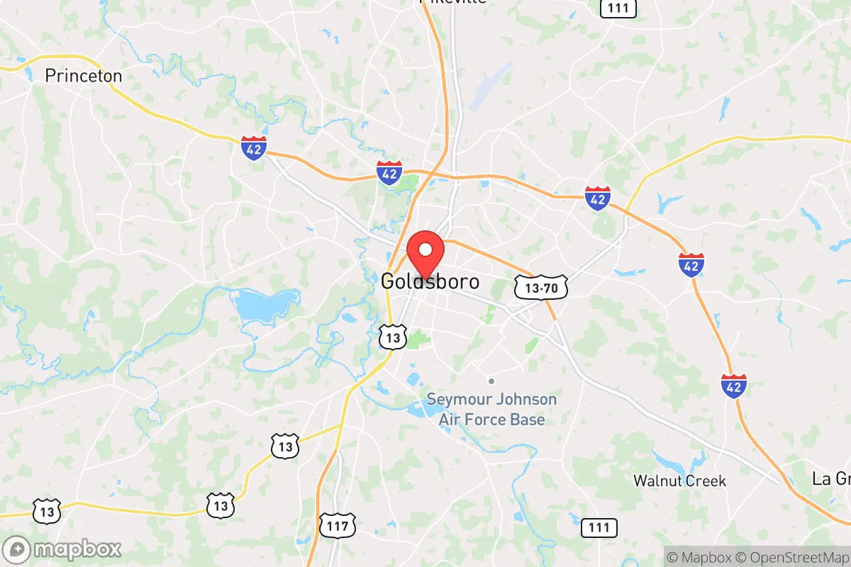
Goldsboro, North Carolina, sits in a precarious but potentially strategic pocket of the eastern Piedmont, roughly 50 miles southeast of Raleigh and 80 miles west of the coast. Its resilience profile is a mixed bag: the city benefits from a strong military presence at Seymour Johnson Air Force Base, which provides a stable economic anchor and a population accustomed to discipline and emergency protocols, but it also carries the inherent risk of being a high-value target in any major conflict. For a relocator thinking in terms of long-term preparedness—civic unrest, supply chain collapse, or mass casualty events—Goldsboro offers a few genuine advantages in food access and water resources, but its proximity to major population centers and a strategic military installation creates a serious risk calculus that cannot be ignored.
Geographic position and natural advantages for long-term survival
Goldsboro’s location in the Neuse River basin gives it a reliable freshwater source, a critical asset for any extended disruption. The Neuse River runs along the city’s northern edge, and the surrounding area is dotted with smaller creeks and wetlands that could support off-grid water collection and filtration. The terrain is flat to gently rolling, which simplifies gardening, livestock grazing, and building defensive perimeters compared to mountainous regions. The climate is humid subtropical, with a growing season that stretches from late March to early November—long enough to produce substantial food yields from a well-planned homestead. The city sits at the intersection of US-70 and US-117, which are major east-west and north-south corridors, but this also means it’s a natural chokepoint for movement during a crisis. For a relocator, the key natural advantage is the combination of abundant surface water, fertile soil, and a moderate climate that reduces heating and cooling demands. The area is also far enough inland to avoid the worst of hurricane storm surges, though it still gets hammered by inland flooding and wind damage from tropical systems.
Risks, exposures, and proximity to fallout-relevant landmarks
The single biggest risk for Goldsboro is its role as the home of Seymour Johnson Air Force Base, which hosts the 4th Fighter Wing and is a key staging point for F-15E Strike Eagles. In any major conflict—especially one involving peer adversaries—this base is a top-tier target for conventional strikes, cyberattacks, or even a tactical nuclear weapon. The base sits just east of downtown Goldsboro, meaning a significant portion of the city lies within the immediate blast and fallout zone of a potential attack. Additionally, Goldsboro is only about 50 miles from Raleigh, a major metropolitan area with over 1.5 million people. During a collapse scenario, you can expect a mass exodus from the Triangle region heading east along US-70, funneling directly through Goldsboro. This creates a serious security and resource-depletion risk. The city itself has a population of roughly 35,000, with a poverty rate around 25%, which could lead to civil unrest if food and fuel supplies dry up. There are no major nuclear power plants within 50 miles, but the state’s eastern coast has several military and industrial sites that could become secondary targets. For a prepper, the proximity to both a high-value military target and a major population center makes Goldsboro a high-risk location unless you can secure a rural property well outside the city limits—ideally 15-20 miles north or south of town, away from the main evacuation routes.
Practical resilience for a relocator: food, water, energy, and defensibility
On the practical side, Goldsboro has some genuine strengths for a self-sufficient setup. The agricultural base in Wayne County is strong—tobacco, soybeans, corn, and livestock operations are common—so local food production is viable if you can secure land. The Neuse River and its tributaries provide ample water, but you’ll need to treat it for agricultural and drinking use due to agricultural runoff and upstream pollution. The water table is high, so shallow wells are feasible in many areas. For energy, the region gets good solar exposure—about 4.5 peak sun hours per day—so a solar array with battery storage can cover basic needs, though you’ll want backup generation for the frequent thunderstorms and occasional hurricanes that knock out grid power. Defensibility is a challenge in the flat terrain; there are no natural chokepoints like mountains or rivers that can be easily fortified. However, the rural areas north of Goldsboro (toward Pikeville and Fremont) offer more wooded, low-density parcels where a property can be set back from main roads, with good visibility and limited access points. The local population includes a significant number of military veterans and active-duty personnel, which means there’s a pool of people with tactical skills and a mindset of preparedness—but it also means there are people who know how to use weapons and organize, which cuts both ways in a crisis. For a relocator, the best play is to buy land at least 10 miles outside the city limits, establish a well and solar setup, and build relationships with local farmers and veterans before any event occurs.
The overall strategic picture for Goldsboro is one of calculated risk. It’s not a safe haven—the military target risk alone disqualifies it for anyone seeking true isolation or security from large-scale conflict. But for a relocator who wants to stay within a few hours of the coast and the Research Triangle, and who is willing to invest in a rural property with robust self-sufficiency systems, the area offers decent water, good growing conditions, and a community that includes a significant number of people who understand discipline and emergency response. The key is to avoid the city itself and the main evacuation corridors, and to treat the entire region as a potential transit zone for refugees from the east and west. If you can secure a defensible homestead with independent water and power, and you’re comfortable with the reality that a major event could turn the area into a contested zone, Goldsboro can work as a base of operations. If you’re looking for a quiet, low-profile retreat with minimal risk, you’d be better off heading further west into the mountains or deeper into the rural coastal plain away from military installations. Goldsboro is a strategic option, not a sanctuary—and that distinction matters when you’re planning for the worst.
* Values derived from national, state, county, city and local statistics and may differ in a specific area. Last updated: 2026-05-03T20:26:42.000Z
Narrative content on this page is AI-generated and may contain mistakes. Verify any details that matter before acting on them.
ReloMaps may earn a commission from affiliate links at no extra cost to you.