
Photo: Wikipedia
Strategic Assessment of Harrisonburg, VA
Meaningful friction. Expect exposure to either population pressure, blast zones, or natural disaster risk. Consider buying a retreat property.
What does the Strategic Assessment tell us?
Our Strategic Assessment grades tactical survivability of an area. Major population centers, military targets, fallout zones, natural disasters, and border exposure all drive risk — lower exposure means a more defensible position in a crisis.
This is heavily inspired by Joel Skousen's Strategic Relocation book. Highly recommended you checkout the book ($)What does this tell us?
Our Strategic Assessment grades tactical survivability of an area. Major population centers, military targets, fallout zones, natural disasters, and border exposure all drive risk — lower exposure means a more defensible position in a crisis.
This is heavily inspired by Joel Skousen's Strategic Relocation book. Highly recommended you checkout the book ($)Strategic Pillars

Key Distances
Regional Safe Places
Below is our recommended "safe zones" in Virginia and the surrounding area based on our strategic heuristics. For most people, it's unrealistic to live in a “safe zone” full-time due to work, family or other personal reasons. They tend to be more rural. However, many of these areas are perfect for second homes and retreat properties that double as a vacation home or even a short-term rental.


Important Note: For informational purposes only. This does not mean nothing bad ever happens in the green zones. Please use common sense. This is based on public data and modeled with AI. We tried to take a conservative approach but mistakes happen. We update this regularly as new information becomes available.
Solar Generator Recommendations
Backup power matters more here than in safer locations. We've picked three solar generators across budgets and capacity tiers — start with the budget unit if you only need a few essentials, or step up if you want to run a fridge and HVAC for days at a time.

Jackery Portable Power Station Explorer 300
Budget OptionPower on the Go: Weighing only 11 lbs, it's convenient to set up and store with book-sized foldable solar panels

BLUETTI Portable Power Station AC180
Designed for both indoor and outdoor scenarios, AC180 is highly capable as it has a robost capacity and continuous output power.

EF ECOFLOW DELTA Pro Ultra Power Station
Upgraded PickEcoFlow DELTA Pro Ultra is a whole-home energy system designed to grow with your family. Integrated with the Smart Home Panel 2, it scales to meet your evolving energy needs — keeping your home powered, intelligent, and secure through every stage of life.
We earn a commission, at no additional cost to you.
Strategic Assessment Analysis
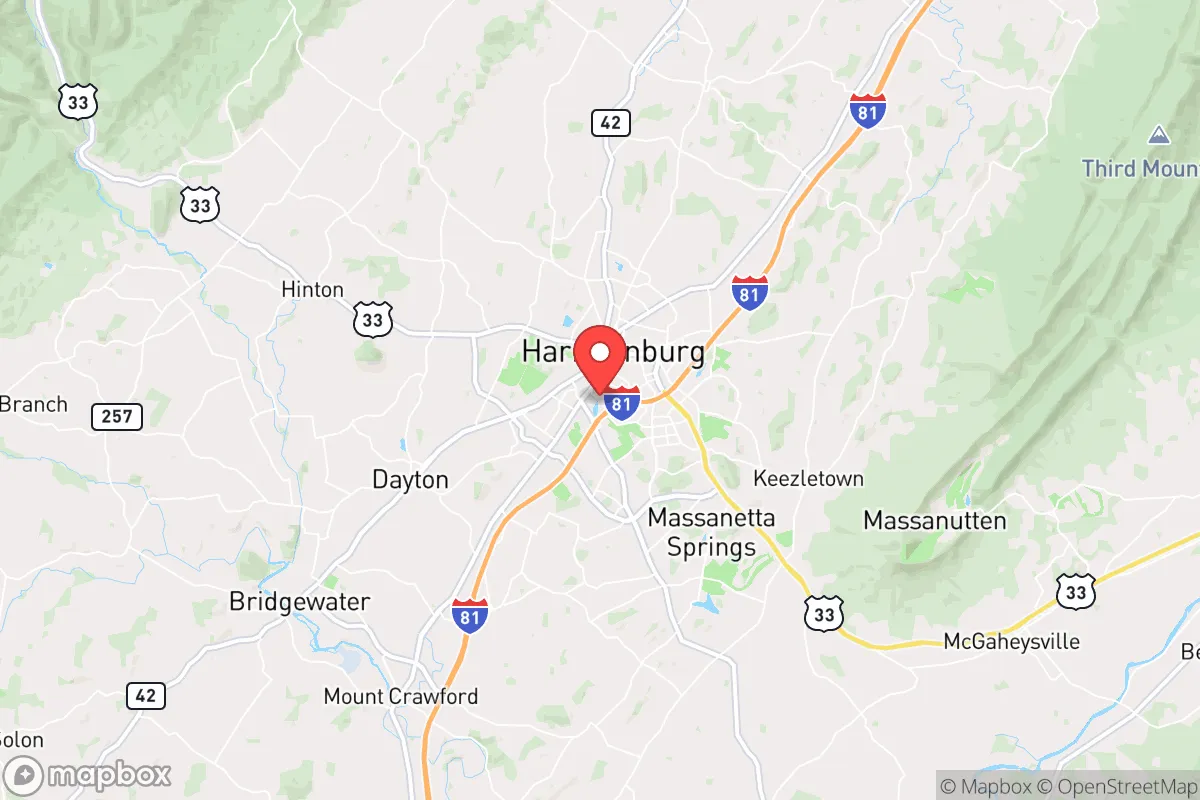
Harrisonburg, Virginia, sits in a strategic pocket of the Shenandoah Valley that offers a compelling mix of geographic insulation and practical self-sufficiency for those prioritizing long-term resilience. Its location roughly 120 miles southwest of Washington, D.C., and 50 miles from the I-95 corridor places it outside the immediate blast and fallout zones of major targets, while still providing access to critical supply routes and regional infrastructure. The city’s position at the intersection of I-81 and US-33 gives it a natural chokepoint advantage—easy to monitor, harder to overwhelm—and the surrounding agricultural land means food production isn’t a theoretical exercise; it’s the local economy.
Geographic position and natural advantages for long-term security
Harrisonburg’s real strength is its position in the Shenandoah Valley, a natural fortress flanked by the Blue Ridge Mountains to the east and the Allegheny Mountains to the west. This topography creates a natural funnel for movement and a barrier against large-scale chaos spilling in from the coastal megalopolis. The valley floor is fertile, well-watered, and historically self-sufficient—during the Civil War, this region fed armies. Today, that same soil supports a robust local food system, with dozens of farms, orchards, and dairies within a 20-minute drive. The North River and the Shenandoah River itself provide surface water sources, and the area’s karst geology means abundant groundwater for those who know how to tap it. Elevation here averages around 1,300 feet, which reduces flood risk compared to lower-lying areas and offers cooler summer temperatures, a small but real advantage in a warming climate. For a relocator, the key takeaway is that Harrisonburg isn’t a desert or a floodplain—it’s a naturally resilient piece of ground that can sustain a population without constant external resupply.
Risks, exposures, and proximity to fallout-relevant landmarks
No location is risk-free, and Harrisonburg has its share of exposures that a prepper must account for. The most obvious is I-81, which runs right through the city. This highway is a major north-south trucking corridor, and in a crisis, it could become a chokepoint for refugees fleeing the D.C. metro area or a target for disruption. The city itself is home to James Madison University (roughly 20,000 students) and Eastern Mennonite University, which means a dense, transient population that could become a liability if civil order breaks down—college towns tend to have less community cohesion and more reliance on just-in-time supply chains. Proximity to the D.C. metro area (about 2 hours by car) means that any major event—nuclear strike, EMP, or large-scale civil unrest—will send a wave of evacuees west along I-66 and US-33. Harrisonburg is also within 100 miles of the Blue Ridge Tunnel and several major power transmission lines that could be targeted in a conflict. On the plus side, there are no nuclear power plants within 50 miles (the closest is North Anna, about 80 miles east), and the area is not a primary target for strategic weapons. The risk profile is moderate: you’re not in a blast zone, but you’re in the path of human chaos.
Practical resilience for a relocator: food, water, energy, and defensibility
For someone serious about self-reliance, Harrisonburg checks most boxes. Food security is the strongest asset: Rockingham County is one of the top agricultural counties in Virginia, producing poultry, dairy, apples, and grains. The Harrisonburg Farmers Market operates year-round, and there are multiple CSAs (community-supported agriculture) within a 15-minute drive. For those looking to grow their own, the growing season runs from April to October, and the soil is workable without heavy amendment. Water is abundant—the city draws from the North River and has a backup reservoir, but for off-grid setups, shallow wells in the valley typically yield 10-20 gallons per minute. Rainwater collection is viable, with an average of 40 inches of precipitation annually. Energy resilience is mixed: the grid is served by Dominion Energy, which has a decent reliability record, but the area is prone to occasional ice storms that can knock out power for days. Solar potential is moderate—the valley gets about 4.5 peak sun hours per day—and there are no major restrictions on residential solar or battery systems in the county. Defensibility is where Harrisonburg shines: the surrounding mountains provide natural observation points, and the valley’s limited entry points (I-81, US-33, and a handful of secondary roads) can be monitored or controlled by a small, organized group. The local gun culture is strong—Virginia is a shall-issue state for concealed carry, and Rockingham County has a high rate of firearm ownership—which means the community is not defenseless. For a relocator, the practical takeaway is that you can live here with a well, a garden, solar panels, and a good rifle, and you’ll be in a position to weather most disruptions without being dependent on government aid.
The overall strategic picture for Harrisonburg is one of calculated advantage. It’s not a remote bunker in the mountains—it’s a functioning small city with a hospital, a regional airport, and a working economy—but it’s far enough from the major targets to avoid the worst of a collapse scenario. The risks are real: the I-81 corridor, the transient student population, and the proximity to D.C. mean that you need a plan for evacuation or shelter-in-place, not just blind optimism. But for a conservative-leaning relocator who values community, self-sufficiency, and a lower risk profile than the suburbs of Richmond or Northern Virginia, Harrisonburg offers a solid foundation. The key is to arrive with your own infrastructure—water storage, energy backup, and a network of like-minded neighbors—because the city’s resilience is only as strong as the people who choose to build it. If you’re looking for a place that can hold its own when the system wobbles, this valley is worth a hard look.
* Values derived from national, state, county, city and local statistics and may differ in a specific area. Last updated: 2026-05-01T18:37:16.000Z
Narrative content on this page is AI-generated and may contain mistakes. Verify any details that matter before acting on them.
ReloMaps may earn a commission from affiliate links at no extra cost to you.