Photo: Wikipedia
Strategic Assessment of Hutchinson, KS
Meaningful friction. Expect exposure to either population pressure, blast zones, or natural disaster risk. Consider buying a retreat property.
What does the Strategic Assessment tell us?
Our Strategic Assessment grades tactical survivability of an area. Major population centers, military targets, fallout zones, natural disasters, and border exposure all drive risk — lower exposure means a more defensible position in a crisis.
This is heavily inspired by Joel Skousen's Strategic Relocation book. Highly recommended you checkout the book ($)What does this tell us?
Our Strategic Assessment grades tactical survivability of an area. Major population centers, military targets, fallout zones, natural disasters, and border exposure all drive risk — lower exposure means a more defensible position in a crisis.
This is heavily inspired by Joel Skousen's Strategic Relocation book. Highly recommended you checkout the book ($)Strategic Pillars

Key Distances
Regional Safe Places
Below is our recommended "safe zones" in Kansas and the surrounding area based on our strategic heuristics. For most people, it's unrealistic to live in a “safe zone” full-time due to work, family or other personal reasons. They tend to be more rural. However, many of these areas are perfect for second homes and retreat properties that double as a vacation home or even a short-term rental.
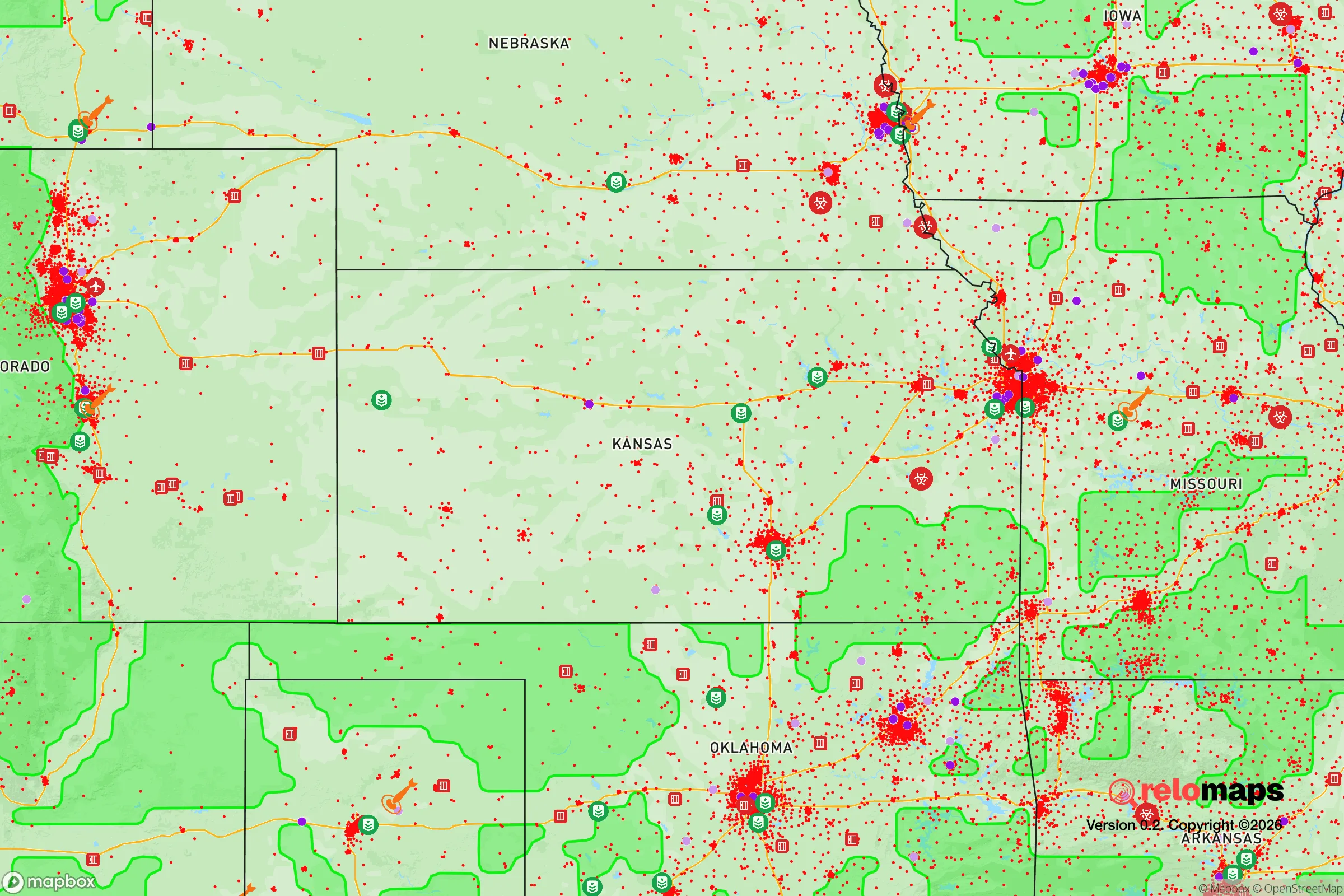
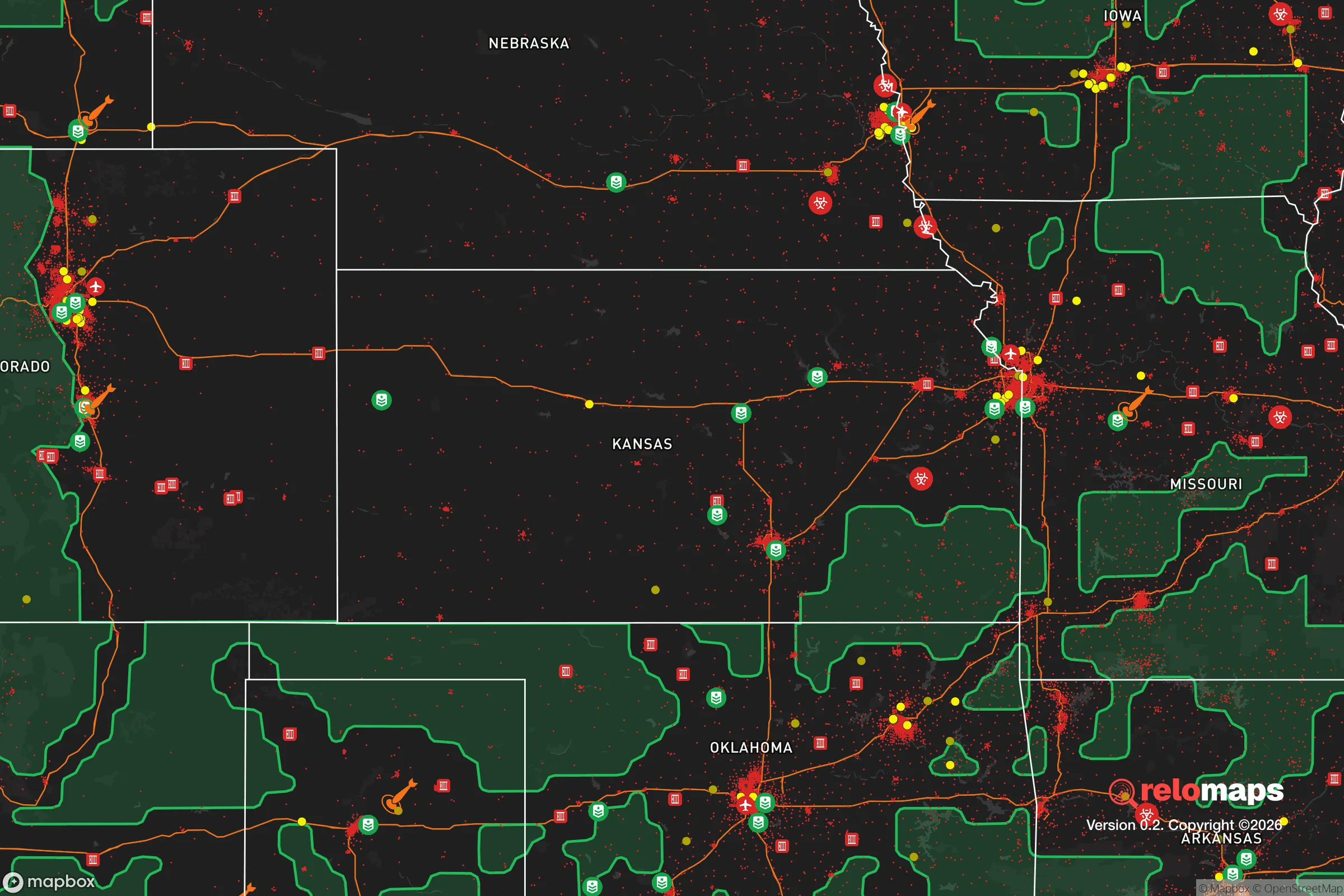
Important Note: For informational purposes only. This does not mean nothing bad ever happens in the green zones. Please use common sense. This is based on public data and modeled with AI. We tried to take a conservative approach but mistakes happen. We update this regularly as new information becomes available.
Solar Generator Recommendations
Backup power matters more here than in safer locations. We've picked three solar generators across budgets and capacity tiers — start with the budget unit if you only need a few essentials, or step up if you want to run a fridge and HVAC for days at a time.

Jackery Portable Power Station Explorer 300
Budget OptionPower on the Go: Weighing only 11 lbs, it's convenient to set up and store with book-sized foldable solar panels

BLUETTI Portable Power Station AC180
Designed for both indoor and outdoor scenarios, AC180 is highly capable as it has a robost capacity and continuous output power.

EF ECOFLOW DELTA Pro Ultra Power Station
Upgraded PickEcoFlow DELTA Pro Ultra is a whole-home energy system designed to grow with your family. Integrated with the Smart Home Panel 2, it scales to meet your evolving energy needs — keeping your home powered, intelligent, and secure through every stage of life.
We earn a commission, at no additional cost to you.
Strategic Assessment Analysis
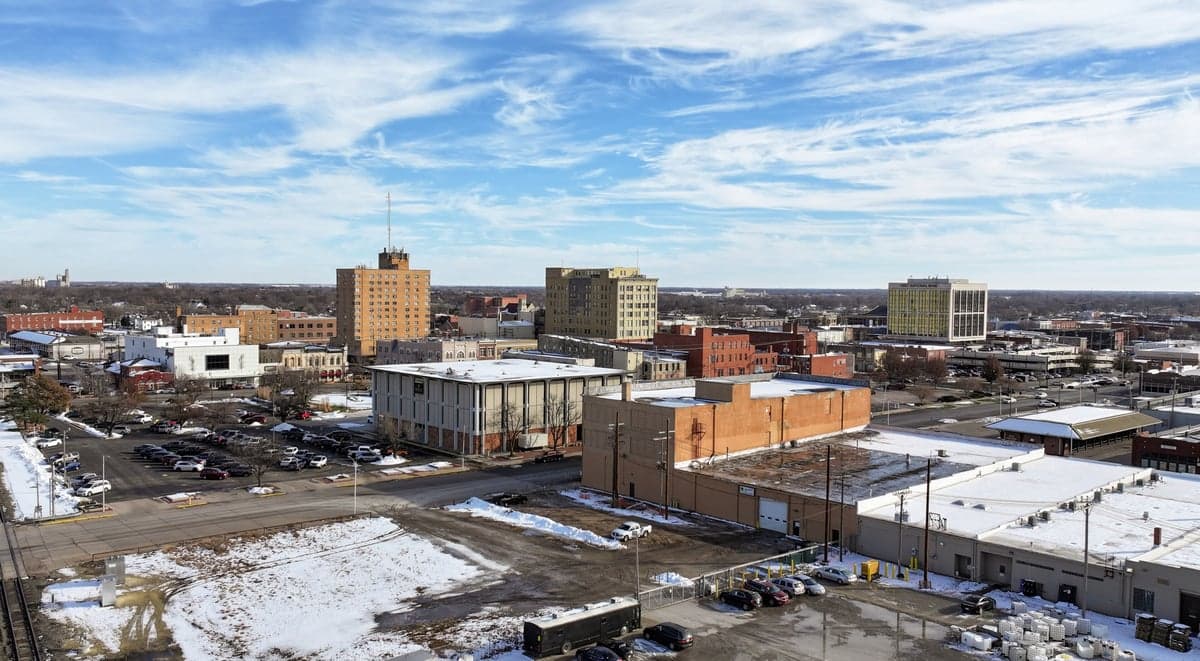
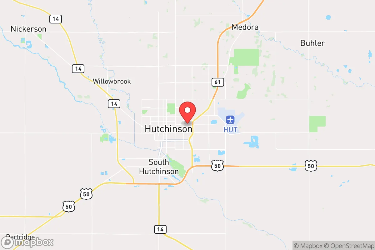
Hutchinson, Kansas, offers a compelling blend of geographic isolation and practical self-sufficiency that appeals to those planning for long-term resilience. Located in the heart of the Great Plains, roughly 50 miles northwest of Wichita, this city of about 40,000 sits far from the coastal population centers and major interstate corridors that would become chokepoints during a crisis. Its position in Reno County places it within a region known for stable geology, low population density, and a strong agricultural base — factors that make it a serious candidate for a strategic relocation from a preparedness standpoint.
Geographic position and natural advantages for long-term security
Hutchinson’s location is defined by its distance from likely targets of civil unrest or infrastructure collapse. The city is roughly 200 miles from the Kansas City metro area and over 350 miles from the Denver Front Range, meaning it sits outside the immediate fallout zones of major urban centers. The surrounding landscape is flat, open farmland, which provides clear lines of sight and limits avenues for large-scale movement of hostile groups. The area’s geology includes the massive Hutchinson Salt Mine, which extends over 650 feet underground and offers a potential hardened shelter resource — though access is controlled by commercial operators. The Arkansas River runs through the city, providing a surface water source, though it is not a major river and can run low during drought years. The region’s average annual rainfall of about 30 inches supports dryland farming without heavy reliance on irrigation, a key advantage for food production if supply chains falter. The climate is continental, with hot summers and cold winters, but the absence of hurricane, earthquake, or wildfire risk reduces the likelihood of natural disaster compounding a man-made crisis.
Risks, exposures, and proximity to fallout-relevant landmarks
No location is without vulnerabilities, and Hutchinson has several that a prepper must weigh. The most obvious is the city’s proximity to the McConnell Air Force Base near Wichita, which houses KC-135 tankers and is a potential target in a conflict involving strategic air power. While 50 miles provides some buffer, prevailing winds from the south-southeast could carry fallout toward Hutchinson in a worst-case scenario. The city itself hosts a major nitrogen fertilizer plant (CVR Partners) and a large grain elevator complex — both industrial targets that could become secondary hazards if attacked or sabotaged. The railroad lines running through Hutchinson (BNSF and Union Pacific) are critical freight corridors; in a collapse scenario, these could become vectors for looting or refugee movement from Wichita. The city’s water treatment plant relies on the Arkansas River and groundwater wells, both of which could be compromised by upstream contamination or power grid failure. On the positive side, Hutchinson’s low population density (about 1,200 people per square mile within city limits) means that a single event is unlikely to overwhelm local resources, and the surrounding county has fewer than 65,000 total residents. The nearest major military target is the aforementioned McConnell base; the next closest is Fort Riley (about 120 miles northeast), which is a large Army post but not a primary nuclear target. The absence of any nuclear power plant within 100 miles reduces the risk of a radiological release from a civilian source.
Practical resilience for a relocator: food, water, energy, and defensibility
For a single individual or family planning to ride out a crisis, Hutchinson offers several concrete advantages. The city sits in the heart of Kansas wheat country, with the Kansas State Fairgrounds hosting one of the largest grain storage facilities in the state. Local farmers produce corn, soybeans, and sorghum in addition to wheat, meaning bulk food sourcing is possible through direct farm-gate purchases. The Reno County Farmers Market operates seasonally, but year-round food storage is feasible given the dry climate — root cellars and underground storage are practical. Water is the more immediate concern: the city’s municipal supply comes from the Equus Beds aquifer, a large groundwater source that also serves Wichita. A private well is the most reliable option for a relocator, and drilling depths in the area range from 50 to 200 feet, with reasonable costs. The city’s power grid is served by Evergy, which relies on a mix of coal, natural gas, and wind — the latter being abundant in the region. Solar panels are viable, with an average of 220 sunny days per year, though winter cloud cover can reduce output. For defensibility, the flat terrain is a double-edged sword: it offers clear sight lines but limited natural cover. A rural property with a good perimeter fence and a well-stocked root cellar would be more defensible than an in-town residence. The local gun culture is strong, with multiple firearms dealers and a county sheriff’s office that is generally supportive of Second Amendment rights. The Reno County Sheriff’s Office has a visible presence, but in a prolonged crisis, law enforcement would likely be stretched thin — self-reliance is the expectation here, not government rescue.
Overall strategic picture for a conservative-minded relocator
Hutchinson represents a middle-ground option for those seeking a balance between isolation and access to essential services. It is not a remote mountain redoubt, but it is far enough from major population centers to avoid the worst of urban collapse scenarios. The city’s agricultural base, stable geology, and low crime rate (violent crime is about 30% below the national average) make it a practical choice for a family that wants to be prepared without living off-grid. The presence of the salt mine and the fertilizer plant are both risks and resources — the mine could serve as a community shelter in a nuclear event, while the plant could be a source of ammonium nitrate for agricultural use or, in the wrong hands, a hazard. The political climate in Reno County leans conservative, with the county voting +36 points Republican in the 2024 presidential election, which aligns with the values of self-reliance and limited government that underpin a prepper mindset. The local economy is stable, anchored by the Kansas Cosmosphere and the salt industry, but job opportunities outside of agriculture and manufacturing are limited — a relocator should have a remote income stream or a trade skill. For a single individual or a family willing to invest in a well, solar panels, and bulk food storage, Hutchinson offers a defensible, low-profile base with a community that shares similar values. The trade-off is the flat terrain and the proximity to Wichita’s military target, but for most scenarios short of full-scale nuclear war, this city provides a solid foundation for long-term survival and self-sufficiency.
* Values derived from national, state, county, city and local statistics and may differ in a specific area. Last updated: 2026-05-01T16:22:02.000Z
Narrative content on this page is AI-generated and may contain mistakes. Verify any details that matter before acting on them.
ReloMaps may earn a commission from affiliate links at no extra cost to you.