Photo: Wikipedia
Strategic Assessment of Jewett City, CT
Multiple tactical vulnerabilities. Population density, target proximity, or disaster risk are likely compounding. A retreat property and exit planning is required.
What does the Strategic Assessment tell us?
Our Strategic Assessment grades tactical survivability of an area. Major population centers, military targets, fallout zones, natural disasters, and border exposure all drive risk — lower exposure means a more defensible position in a crisis.
This is heavily inspired by Joel Skousen's Strategic Relocation book. Highly recommended you checkout the book ($)What does this tell us?
Our Strategic Assessment grades tactical survivability of an area. Major population centers, military targets, fallout zones, natural disasters, and border exposure all drive risk — lower exposure means a more defensible position in a crisis.
This is heavily inspired by Joel Skousen's Strategic Relocation book. Highly recommended you checkout the book ($)Strategic Pillars

Key Distances
Regional Safe Places
Below is our recommended "safe zones" in Connecticut and the surrounding area based on our strategic heuristics. For most people, it's unrealistic to live in a “safe zone” full-time due to work, family or other personal reasons. They tend to be more rural. However, many of these areas are perfect for second homes and retreat properties that double as a vacation home or even a short-term rental.


Important Note: For informational purposes only. This does not mean nothing bad ever happens in the green zones. Please use common sense. This is based on public data and modeled with AI. We tried to take a conservative approach but mistakes happen. We update this regularly as new information becomes available.
Solar Generator Recommendations
Backup power matters more here than in safer locations. We've picked three solar generators across budgets and capacity tiers — start with the budget unit if you only need a few essentials, or step up if you want to run a fridge and HVAC for days at a time.

Jackery Portable Power Station Explorer 300
Budget OptionPower on the Go: Weighing only 11 lbs, it's convenient to set up and store with book-sized foldable solar panels

BLUETTI Portable Power Station AC180
Designed for both indoor and outdoor scenarios, AC180 is highly capable as it has a robost capacity and continuous output power.

EF ECOFLOW DELTA Pro Ultra Power Station
Upgraded PickEcoFlow DELTA Pro Ultra is a whole-home energy system designed to grow with your family. Integrated with the Smart Home Panel 2, it scales to meet your evolving energy needs — keeping your home powered, intelligent, and secure through every stage of life.
We earn a commission, at no additional cost to you.
Strategic Assessment Analysis
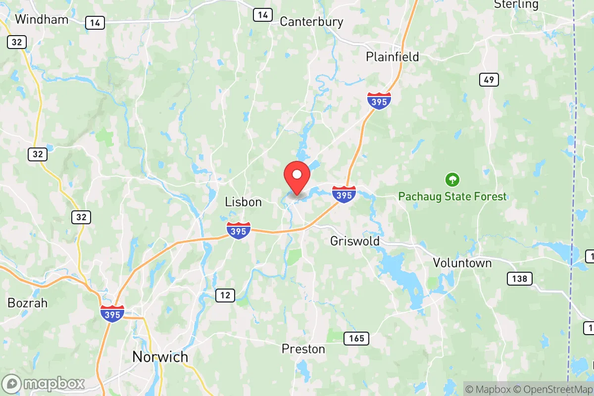
Jewett City, Connecticut, presents a mixed strategic picture for the prepper or survivalist relocator. While its small-town character and location in the relatively rural eastern part of the state offer some buffer from the worst of urban collapse, its proximity to major population centers and critical infrastructure introduces significant vulnerabilities. The area’s resilience is tied directly to its ability to remain off the radar during a crisis, but its position within the densely populated Northeast corridor means that any large-scale event—whether natural, economic, or societal—will likely ripple through this community with less delay than a truly remote location would experience.
Geographic position and natural advantages for long-term survival
Jewett City sits in the Quinebaug River valley, surrounded by the rolling hills and mixed hardwood forests of eastern Connecticut. This terrain offers a degree of natural defensibility, with the river providing a potential water source and the wooded areas offering cover and resources for foraging or hunting. The town itself is small—roughly 3,500 residents—which means a lower population density than most of the state, reducing competition for resources in a grid-down scenario. The surrounding region, including the Pachaug State Forest and the Quinebaug River watershed, provides a buffer of undeveloped land that could serve as a retreat zone or a source of timber, game, and wild edibles. The area’s agricultural history is still visible in scattered farms and orchards, though most are small operations. For a relocator, the key natural advantage is the availability of surface water and the relative isolation from the immediate blast zones of major cities like Hartford (45 miles west) or Providence (40 miles east). However, the terrain is not mountainous, so it lacks the high-ground security that some preppers prioritize. The climate is typical New England—cold winters, moderate summers—which means a need for robust heating and food storage planning.
Risks, exposures, and proximity to fallout-relevant landmarks
The most glaring vulnerability for Jewett City is its location within the shadow of the Millstone Nuclear Power Station in Waterford, roughly 20 miles south along the coast. While a full meltdown is a low-probability event, the consequences would be catastrophic for the entire region, including Jewett City, which lies within the 50-mile ingestion pathway zone. Additionally, the town is situated near Interstate 395, a major north-south corridor that connects to the New York City metro area via I-95. In a mass evacuation or civil unrest scenario, this highway would become a chokepoint and a vector for displaced populations moving inland. The nearby Mohegan Sun and Foxwoods casinos, while economic drivers, are also high-density gathering points that could become targets for looting or violence during a breakdown. The town itself has no major military installations, but the nearby Naval Submarine Base New London in Groton (25 miles south) is a strategic asset that could draw enemy action or become a focal point for federal security operations. For the prepper, the risk profile is moderate: you are not in a primary target zone, but you are close enough to feel the shockwaves of any major event in the Northeast corridor.
Practical resilience for a relocator: food, water, energy, and defensibility
For a single individual or family looking to establish a resilient homestead, Jewett City offers some practical advantages but requires significant upfront investment. The town’s water supply comes from the Jewett City Water Company, which draws from the Quinebaug River and local wells. In a prolonged outage, a private well with a hand pump or a rainwater catchment system would be essential, as municipal treatment plants are vulnerable to power loss and contamination. The local soil is a mix of sandy loam and clay, suitable for gardening with proper amendment, but the growing season is short (roughly 150 days). A greenhouse or cold frames would extend production. For energy, the area has decent solar exposure, but tree cover on many lots limits panel placement. Wood heating is viable given the surrounding forests, but a chainsaw and a supply of dry firewood are non-negotiable for winter. Defensibility is moderate: the town’s layout is a typical New England village with a central green and narrow streets, which can be monitored but also creates chokepoints for movement. The surrounding rural roads offer multiple egress routes, but they are not well-maintained in winter. The nearest major hospital is in Norwich (10 miles west), which is a vulnerability if medical care is needed during a crisis. For food storage, the local grocery options are limited to a few small markets; a deep pantry and a plan for bulk purchasing from regional suppliers in Norwich or Willimantic would be wise. The community itself is tight-knit, which can be a double-edged sword—good for mutual aid, but also for gossip that could compromise a low-profile operation.
Overall, Jewett City is a moderate-risk, moderate-reward relocation option for the conservative prepper. It offers enough distance from the worst urban fallout zones to provide a survival window, but not enough isolation to guarantee safety from regional cascading failures. The area’s natural resources—water, wood, and some arable land—are real assets, but they require active management and a willingness to invest in off-grid infrastructure. The proximity to nuclear infrastructure and major transit corridors is a persistent concern that cannot be ignored. For a relocator who is serious about preparedness, Jewett City could work as a base of operations, but only if paired with a more remote bug-out location further north in Vermont or New Hampshire. The strategic takeaway: this is a place to live and prepare, not a place to hide and wait out a collapse. If you are willing to put in the work—digging a well, stocking a pantry, learning to hunt and preserve food—it can be a viable long-term home. But if you are looking for a true retreat with minimal exposure, keep driving north.
* Values derived from national, state, county, city and local statistics and may differ in a specific area. Last updated: 2026-04-19T07:50:33.000Z
Narrative content on this page is AI-generated and may contain mistakes. Verify any details that matter before acting on them.
ReloMaps may earn a commission from affiliate links at no extra cost to you.