Photo: Wikipedia
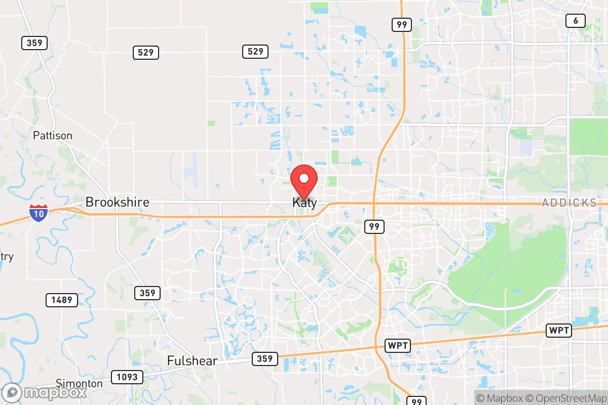
Strategic Assessment of Katy, TX
Multiple tactical vulnerabilities. Population density, target proximity, or disaster risk are likely compounding. A retreat property and exit planning is required.
What does the Strategic Assessment tell us?
Our Strategic Assessment grades tactical survivability of an area. Major population centers, military targets, fallout zones, natural disasters, and border exposure all drive risk — lower exposure means a more defensible position in a crisis.
This is heavily inspired by Joel Skousen's Strategic Relocation book. Highly recommended you checkout the book ($)What does this tell us?
Our Strategic Assessment grades tactical survivability of an area. Major population centers, military targets, fallout zones, natural disasters, and border exposure all drive risk — lower exposure means a more defensible position in a crisis.
This is heavily inspired by Joel Skousen's Strategic Relocation book. Highly recommended you checkout the book ($)Strategic Pillars

Key Distances
Regional Safe Places
Below is our recommended "safe zones" in Texas and the surrounding area based on our strategic heuristics. For most people, it's unrealistic to live in a “safe zone” full-time due to work, family or other personal reasons. They tend to be more rural. However, many of these areas are perfect for second homes and retreat properties that double as a vacation home or even a short-term rental.


Important Note: For informational purposes only. This does not mean nothing bad ever happens in the green zones. Please use common sense. This is based on public data and modeled with AI. We tried to take a conservative approach but mistakes happen. We update this regularly as new information becomes available.
Solar Generator Recommendations
Backup power matters more here than in safer locations. We've picked three solar generators across budgets and capacity tiers — start with the budget unit if you only need a few essentials, or step up if you want to run a fridge and HVAC for days at a time.

Jackery Portable Power Station Explorer 300
Budget OptionPower on the Go: Weighing only 11 lbs, it's convenient to set up and store with book-sized foldable solar panels

BLUETTI Portable Power Station AC180
Designed for both indoor and outdoor scenarios, AC180 is highly capable as it has a robost capacity and continuous output power.

EF ECOFLOW DELTA Pro Ultra Power Station
Upgraded PickEcoFlow DELTA Pro Ultra is a whole-home energy system designed to grow with your family. Integrated with the Smart Home Panel 2, it scales to meet your evolving energy needs — keeping your home powered, intelligent, and secure through every stage of life.
We earn a commission, at no additional cost to you.
Strategic Assessment Analysis
Katy, Texas, presents a complex strategic picture for the conservative prepper or survivalist. Its primary advantage is its position as a resilient economic and logistical hub, sitting on the I-10 corridor and the Grand Parkway, which provides multiple egress routes and supply chain access. However, its explosive growth and proximity to Houston introduce significant vulnerabilities that a serious relocator must weigh against the area's genuine strengths in community organization and resource availability.
Geographic position and natural advantages for long-term security
Katy’s location is its strongest card. Situated roughly 30 miles west of downtown Houston, it sits at the intersection of two major evacuation arteries: I-10 (the Katy Freeway) and the Grand Parkway (SH 99). This grid provides multiple options for movement during a crisis, unlike many suburban areas that have only one way in or out. The land itself is relatively flat but well-drained, with the Brazos River to the southwest and the San Jacinto River basin to the east. For a prepper, the key natural advantage is the presence of the Gulf Coast Aquifer, which provides a deep, reliable groundwater source for those who drill a private well—a critical consideration if municipal water treatment fails. The area’s clay soils are poor for traditional farming but support robust native grasses and livestock, meaning a small homestead with rotational grazing is feasible. The climate is humid subtropical, with a long growing season (roughly 250 days), allowing for year-round food production if you can manage the heat and pests. The proximity to the Texas Gulf Coast also means access to marine resources, but that same proximity introduces the area’s primary natural risk: hurricanes and tropical storms, which can knock out power and infrastructure for weeks.
Risks, exposures, and proximity to fallout-relevant landmarks
This is where the analysis gets sobering. Katy’s biggest strategic weakness is its proximity to Houston, a major population center and a prime target for civil unrest, mass casualty events, or infrastructure collapse. Katy is within the 50-mile blast radius of the Houston Ship Channel, a massive concentration of petrochemical refineries, LNG terminals, and chemical plants. A major industrial accident, terrorist attack, or EMP event at the Ship Channel would create a toxic plume that could drift directly over Katy depending on prevailing winds. Furthermore, the Texas Medical Center (TMC) in Houston is a high-value target for any actor seeking to cripple regional healthcare. If the TMC is compromised, Katy’s own hospitals—though good—would be overwhelmed by refugees. The area is also a major transportation corridor: I-10 is a primary route for military and FEMA convoys, making it a potential chokepoint or target during a national emergency. On the natural disaster front, Katy sits in a floodplain, though less severe than areas closer to Buffalo Bayou. The 2017 Hurricane Harvey flooding was a wake-up call, with many subdivisions west of the Grand Parkway experiencing street flooding. Any property purchase must include a thorough flood-risk assessment, as FEMA maps are often outdated. Finally, the explosive population growth (Katy has more than doubled in size since 2010) means that during a crisis, the area’s roads—already congested—would become impassable. The sheer density of people in the master-planned communities (Cinco Ranch, Seven Meadows, etc.) creates a logistical nightmare for evacuation and a security risk if civil order breaks down.
Practical resilience for a relocator: food, water, energy, and defensibility
For the individual or family serious about preparedness, Katy offers a mixed bag. Water is the most critical vulnerability. The municipal water supply comes from surface water (the Brazos River and Lake Houston) and is treated at plants that are vulnerable to power loss and contamination. A private well is the gold standard, but drilling in Katy’s clay and sand can cost $10,000–$20,000, and you must test for high iron and sulfur. Rainwater catchment is viable, with average annual rainfall of 48 inches, but requires large cisterns and filtration. Food production is possible but not easy. The soil is heavy clay, so raised beds or hugelkultur mounds are necessary. The long growing season allows for tomatoes, peppers, okra, and squash, but the heat and humidity make pest management a constant battle. Local farmers’ markets and the presence of the Katy Area Farmers Market provide some local food sourcing, but don't count on them in a crisis. Energy resilience is a bright spot. Texas’s deregulated grid means you can install solar panels with battery backup (e.g., Tesla Powerwall) and disconnect from the grid during outages. Natural gas generators are also common, given the area’s abundant gas infrastructure. However, the ERCOT grid is notoriously fragile; winter storms (like Uri in 2021) can knock out power for days, so a backup heating source (wood stove or propane) is essential. Defensibility is the hardest factor. Katy is a sprawling suburb with few natural chokepoints. The master-planned communities have gated entrances, but those are cosmetic, not hardened. A better option is to buy a property on the western or northern fringe—near Brookshire or Fulshear—where you can have acreage and a longer standoff distance from neighbors. The local law enforcement (Harris County Sheriff’s Office and Katy PD) is professional but stretched thin; during a major event, response times would be measured in hours, not minutes. Community is your best defense. The conservative culture in Katy is strong, with many churches, gun clubs, and veteran organizations. Building a mutual assistance group (MAG) with like-minded neighbors is the single most effective resilience strategy.
The overall strategic picture for Katy is one of calculated risk. It is not a remote bug-out location; it is a suburban hub with significant exposure to Houston’s vulnerabilities. However, for the relocator who wants to maintain a professional career while building a resilient homestead, Katy offers a rare combination: a strong local economy, access to major transportation corridors, a conservative community, and the potential for self-sufficiency on the fringe. The key is to buy on the western edge, drill a well, install solar, and build a network of trusted neighbors. If you do that, you can weather most storms—literal and figurative—while still being close enough to Houston to work and access resources. If you buy in the middle of a dense subdivision, you are betting that the system holds. For a survivalist, that’s a bet you don’t want to make.
* Values derived from national, state, county, city and local statistics and may differ in a specific area. Last updated: 2026-04-19T07:20:01.000Z
Narrative content on this page is AI-generated and may contain mistakes. Verify any details that matter before acting on them.
ReloMaps may earn a commission from affiliate links at no extra cost to you.