Photo: Wikipedia
Strategic Assessment of Keizer, OR
Multiple tactical vulnerabilities. Population density, target proximity, or disaster risk are likely compounding. A retreat property and exit planning is required.
What does the Strategic Assessment tell us?
Our Strategic Assessment grades tactical survivability of an area. Major population centers, military targets, fallout zones, natural disasters, and border exposure all drive risk — lower exposure means a more defensible position in a crisis.
This is heavily inspired by Joel Skousen's Strategic Relocation book. Highly recommended you checkout the book ($)What does this tell us?
Our Strategic Assessment grades tactical survivability of an area. Major population centers, military targets, fallout zones, natural disasters, and border exposure all drive risk — lower exposure means a more defensible position in a crisis.
This is heavily inspired by Joel Skousen's Strategic Relocation book. Highly recommended you checkout the book ($)Strategic Pillars

Key Distances
Regional Safe Places
Below is our recommended "safe zones" in Oregon and the surrounding area based on our strategic heuristics. For most people, it's unrealistic to live in a “safe zone” full-time due to work, family or other personal reasons. They tend to be more rural. However, many of these areas are perfect for second homes and retreat properties that double as a vacation home or even a short-term rental.


Important Note: For informational purposes only. This does not mean nothing bad ever happens in the green zones. Please use common sense. This is based on public data and modeled with AI. We tried to take a conservative approach but mistakes happen. We update this regularly as new information becomes available.
Solar Generator Recommendations
Backup power matters more here than in safer locations. We've picked three solar generators across budgets and capacity tiers — start with the budget unit if you only need a few essentials, or step up if you want to run a fridge and HVAC for days at a time.

Jackery Portable Power Station Explorer 300
Budget OptionPower on the Go: Weighing only 11 lbs, it's convenient to set up and store with book-sized foldable solar panels

BLUETTI Portable Power Station AC180
Designed for both indoor and outdoor scenarios, AC180 is highly capable as it has a robost capacity and continuous output power.

EF ECOFLOW DELTA Pro Ultra Power Station
Upgraded PickEcoFlow DELTA Pro Ultra is a whole-home energy system designed to grow with your family. Integrated with the Smart Home Panel 2, it scales to meet your evolving energy needs — keeping your home powered, intelligent, and secure through every stage of life.
We earn a commission, at no additional cost to you.
Strategic Assessment Analysis
Keizer, Oregon, sits in a precarious but potentially advantageous position for a strategic relocation, offering a blend of suburban quiet and proximity to the Willamette Valley’s agricultural heartland, yet it is dangerously close to Portland’s urban chaos and the region’s major infrastructure targets. For a conservative-leaning prepper or survivalist, this area presents a mixed bag: you get access to fertile land and water, but you are also within the fallout zone of a major metropolitan collapse, a Cascadia Subduction Zone earthquake, or a coordinated attack on critical infrastructure. The key to surviving here is not just stockpiling supplies, but understanding the geography, the risks, and the practical steps to make this location work as a long-term base of operations.
Geographic position and natural advantages for long-term survival
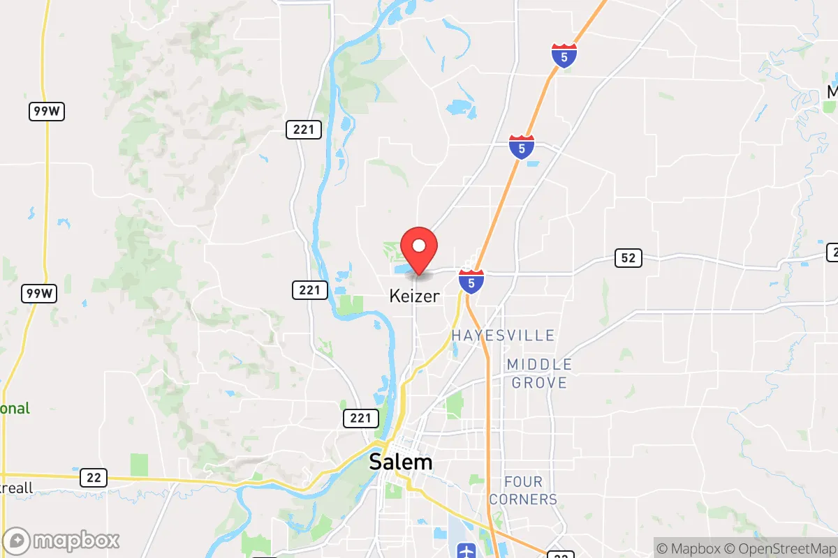
Keizer’s location is defined by its position in the northern Willamette Valley, roughly 50 miles south of Portland and 5 miles north of Salem, the state capital. This places it within a fertile agricultural corridor that produces a significant portion of the region’s food, including berries, hazelnuts, and grass seed. The Willamette River runs along the city’s eastern edge, providing a reliable surface water source, though it is also a floodplain. The area benefits from a mild maritime climate—wet winters and dry summers—which supports year-round gardening and livestock grazing without the extreme cold or heat that plagues other parts of the country. The surrounding Coast Range to the west and the Cascade Range to the east offer natural barriers that could slow the movement of displaced populations from Portland in a collapse scenario, but they also create chokepoints on major highways like I-5, which runs directly through Keizer. For a relocator, the ability to tap into local food production and water is a genuine advantage, but you must be prepared for the fact that this same fertility makes the area a target for resource-seeking refugees from the north.
Risks, exposures, and proximity to fallout-relevant landmarks
The most significant strategic risk for Keizer is its proximity to Portland, a major population center and a likely epicenter of civil unrest, supply chain disruption, or a mass casualty event. In a scenario where Portland experiences a catastrophic event—whether from an earthquake, a terrorist attack, or a societal breakdown—Keizer sits directly in the path of the expected exodus along I-5. The city is also within 10 miles of the Salem-Keizer Transit system’s rail lines and the Oregon State Capitol, both of which could become targets for political violence or infrastructure sabotage. Furthermore, the area is in the Cascadia Subduction Zone’s impact zone, meaning a major earthquake (magnitude 9.0 or higher) could cause widespread liquefaction, bridge collapses, and tsunami-like flooding in the Willamette River valley. The nearby McNary Dam on the Columbia River, about 40 miles north, is a critical piece of energy infrastructure that, if compromised, could cause cascading power failures and flooding. For a survivalist, these exposures mean that Keizer is not a retreat; it is a forward operating base that requires constant situational awareness and a plan to bug out to higher ground or more rural areas if the worst happens.
Practical resilience for a relocator: food, water, energy, and defensibility
For a single individual or family looking to establish a resilient homestead, Keizer offers a few concrete advantages but requires significant preparation. The city’s water supply comes from the Santiam River and the Willamette River, but municipal treatment plants are vulnerable to earthquake damage and power outages. A well on private property is the gold standard here, but many suburban lots in Keizer are on city water, so you must either drill a well (if zoning allows) or have a robust rainwater catchment system with filtration. The soil is rich and loamy, ideal for raised-bed gardening, and the growing season runs from April to October, allowing for substantial food production if you have the space. Energy-wise, the area is served by Portland General Electric, which is prone to ice storms and wildfire-related outages; solar panels with battery storage are a wise investment, but note that the region’s frequent cloud cover in winter reduces solar yield by 30-40% compared to sunnier states. Defensibility is a challenge: Keizer is a suburban grid of cul-de-sacs and arterial roads, making it hard to secure a perimeter. A better approach is to choose a property on the city’s rural fringe—near the agricultural areas west of River Road or east of I-5—where you have more land, fewer neighbors, and better escape routes. Stockpiling ammunition, medical supplies, and tools for barter is essential, as local stores will be stripped within hours of a major event.
The overall strategic picture for Keizer is one of calculated risk. It is not a remote bunker location, nor is it a high-security redoubt. Instead, it is a place where a prepared individual can leverage the region’s natural abundance—water, fertile soil, mild climate—while accepting the inherent dangers of being near a major urban center and a seismic fault line. For a conservative-leaning relocator who values community, local governance, and the ability to live a self-sufficient lifestyle, Keizer can work if you are willing to invest in redundancy: backup water, off-grid power, a deep pantry, and a network of like-minded neighbors. The key is to treat this as a base, not a final destination. Have a bug-out vehicle ready, know the back roads to the Coast Range or the Cascades, and keep a low profile. In a world where the state of the country and the world is uncertain, Keizer offers a foothold in a productive region, but only for those who understand that survival here depends on preparation, not luck.
* Values derived from national, state, county, city and local statistics and may differ in a specific area. Last updated: 2026-05-17T23:02:40.000Z
Narrative content on this page is AI-generated and may contain mistakes. Verify any details that matter before acting on them.
ReloMaps may earn a commission from affiliate links at no extra cost to you.