
Photo: Wikipedia
Strategic Assessment of Kiryas Joel, NY
Multiple tactical vulnerabilities. Population density, target proximity, or disaster risk are likely compounding. A retreat property and exit planning is required.
What does the Strategic Assessment tell us?
Our Strategic Assessment grades tactical survivability of an area. Major population centers, military targets, fallout zones, natural disasters, and border exposure all drive risk — lower exposure means a more defensible position in a crisis.
This is heavily inspired by Joel Skousen's Strategic Relocation book. Highly recommended you checkout the book ($)What does this tell us?
Our Strategic Assessment grades tactical survivability of an area. Major population centers, military targets, fallout zones, natural disasters, and border exposure all drive risk — lower exposure means a more defensible position in a crisis.
This is heavily inspired by Joel Skousen's Strategic Relocation book. Highly recommended you checkout the book ($)Strategic Pillars

Key Distances
Regional Safe Places
Below is our recommended "safe zones" in New York and the surrounding area based on our strategic heuristics. For most people, it's unrealistic to live in a “safe zone” full-time due to work, family or other personal reasons. They tend to be more rural. However, many of these areas are perfect for second homes and retreat properties that double as a vacation home or even a short-term rental.


Important Note: For informational purposes only. This does not mean nothing bad ever happens in the green zones. Please use common sense. This is based on public data and modeled with AI. We tried to take a conservative approach but mistakes happen. We update this regularly as new information becomes available.
Solar Generator Recommendations
Backup power matters more here than in safer locations. We've picked three solar generators across budgets and capacity tiers — start with the budget unit if you only need a few essentials, or step up if you want to run a fridge and HVAC for days at a time.

Jackery Portable Power Station Explorer 300
Budget OptionPower on the Go: Weighing only 11 lbs, it's convenient to set up and store with book-sized foldable solar panels

BLUETTI Portable Power Station AC180
Designed for both indoor and outdoor scenarios, AC180 is highly capable as it has a robost capacity and continuous output power.

EF ECOFLOW DELTA Pro Ultra Power Station
Upgraded PickEcoFlow DELTA Pro Ultra is a whole-home energy system designed to grow with your family. Integrated with the Smart Home Panel 2, it scales to meet your evolving energy needs — keeping your home powered, intelligent, and secure through every stage of life.
We earn a commission, at no additional cost to you.
Strategic Assessment Analysis
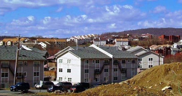
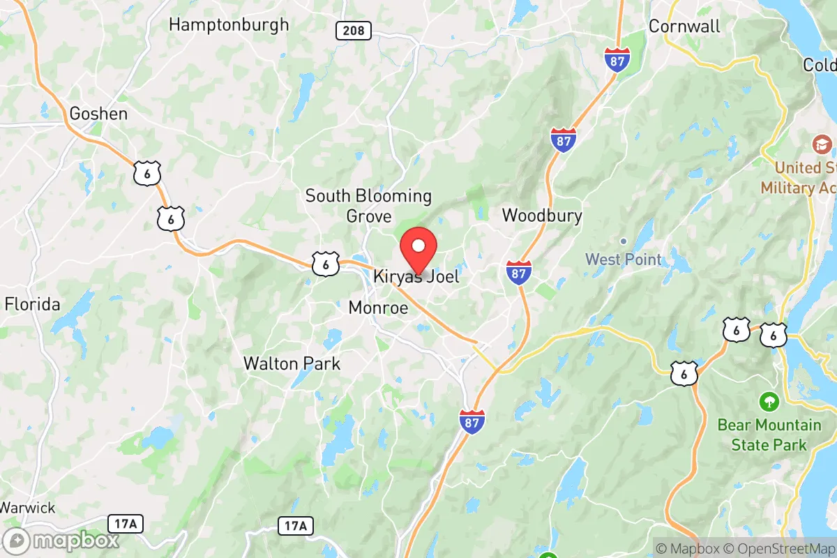
Kiryas Joel, a rapidly growing Hasidic village in Orange County, New York, presents a uniquely complex strategic picture for the conservative prepper. Its primary resilience advantage is its insular, high-trust community structure and its location roughly 50 miles northwest of Manhattan—close enough to monitor urban collapse, but far enough to avoid the immediate blast radius of a major event. However, its extreme population density (over 30,000 people packed into less than two square miles), its reliance on a single water source, and its proximity to the New York City metro area’s fallout and unrest risks make it a high-risk, high-reward proposition for the survival-minded relocator.
Geographic position and natural advantages for long-term survival
Kiryas Joel sits in the Hudson Valley, a region with genuine strategic depth. The village is nestled in a valley surrounded by the Schunemunk and Bear Mountain ranges, offering natural terrain that could slow the movement of large, disorganized groups in a collapse scenario. The area’s soils are generally fertile, and the surrounding Orange County countryside has a strong agricultural tradition—orchards, dairy farms, and vegetable operations are within a 15-minute drive. This means local food production is viable, not just theoretical. The village itself is built on a plateau above the Moodna Creek watershed, providing decent drainage and access to groundwater. For the prepper, the key natural advantage is the proximity to the Catskill Mountains and the Delaware River watershed, both less than 30 minutes away. These areas offer true wilderness retreat options, abundant game, and reliable surface water. The local climate is four-season, with cold winters that naturally limit pest-borne disease and force a discipline of stored heat and food—a hardening factor that warmer regions lack.
Risks, exposures, and proximity to fallout-relevant landmarks
The single greatest strategic liability of Kiryas Joel is its location within the New York City metropolitan statistical area. While 50 miles from Midtown, the village is within 30 miles of the Indian Point Energy Center (now decommissioned but still housing spent fuel) and within 20 miles of the Stewart Air National Guard Base, a potential military logistics hub in a crisis. A conventional or dirty-bomb attack on Manhattan would send fallout plumes that, depending on wind direction, could directly impact the village. The village’s extreme density—apartment blocks and row houses packed on narrow streets—means that a single contagious disease event or a panic-driven evacuation could turn into a humanitarian disaster within hours. The main access road, NY-17M, is a two-lane artery that bottlenecks quickly; the only other egress is through the village of Monroe, which is equally constrained. There is no rail or mass transit redundancy for evacuation. Furthermore, the village’s population is almost entirely dependent on the outside economy—most residents work in Brooklyn or Monsey—meaning a prolonged economic shutdown would collapse the local tax base and food supply chain within weeks. For the prepper, this is a location that could become a trap if the crisis is regional rather than local.
Practical resilience for a relocator: food, water, energy, and defensibility
On the practical side, Kiryas Joel offers some surprising strengths and glaring weaknesses. The village’s water supply comes from the Kiryas Joel Water District, which draws from two wells in the fractured bedrock aquifer. This is a single-point-of-failure system: a contamination event or pump failure would leave 30,000+ people without potable water. A prepper relocating here would need to invest in a deep private well (if on the outskirts) or a serious rainwater catchment and filtration system. Electricity comes from Central Hudson, a utility that has a mixed record on storm restoration; the village has no municipal backup generation. Natural gas is piped in, but a grid-down scenario means no heat, no cooking, and no hot water for the majority of residents. Food resilience is poor: there are no large-scale grocery stores within the village—residents rely on small kosher markets and weekly trips to Walmart or ShopRite in Monroe. Local food production is essentially zero within the village boundaries. Defensibility is a double-edged sword. The insular community, with its own security patrols (the Kiryas Joel Public Safety Department) and a culture of mutual aid, could form a highly effective neighborhood watch. Outsiders are immediately noticeable, which is a security asset. However, the sheer density means that a determined group could not be kept out by physical barriers—the village is too porous. The best strategic play for a relocator here is to buy property on the rural fringe of the village, near the wooded hills to the west, where you can have acreage, a private well, and a defensible perimeter while still benefiting from the community’s social cohesion.
The overall strategic picture for Kiryas Joel is one of extreme trade-offs. It is not a location for the lone-wolf prepper; it is a location for someone who values community above all else and is willing to accept the risks of density and proximity to a major target zone. If you are looking for a place where you can hunker down with a tight-knit group that shares your values, where you can trade skills and labor, and where the surrounding countryside offers a bug-out option, Kiryas Joel has potential. But if your plan relies on self-sufficiency, low population density, and distance from fallout dangers, this village is a hard pass. The smartest approach is to treat Kiryas Joel as a forward operating base—a place to build relationships and cache supplies, while maintaining a true retreat property further north in the Catskills. In a real crisis, the village’s strengths (community, terrain, proximity to wilderness) could be leveraged, but only if you have already planned for the day the roads out of Monroe become impassable.
* Values derived from national, state, county, city and local statistics and may differ in a specific area. Last updated: 2026-05-01T08:55:00.000Z
Narrative content on this page is AI-generated and may contain mistakes. Verify any details that matter before acting on them.
ReloMaps may earn a commission from affiliate links at no extra cost to you.