Photo: Wikipedia
Strategic Assessment of Lancaster, CA
Multiple tactical vulnerabilities. Population density, target proximity, or disaster risk are likely compounding. A retreat property and exit planning is required.
What does the Strategic Assessment tell us?
Our Strategic Assessment grades tactical survivability of an area. Major population centers, military targets, fallout zones, natural disasters, and border exposure all drive risk — lower exposure means a more defensible position in a crisis.
This is heavily inspired by Joel Skousen's Strategic Relocation book. Highly recommended you checkout the book ($)What does this tell us?
Our Strategic Assessment grades tactical survivability of an area. Major population centers, military targets, fallout zones, natural disasters, and border exposure all drive risk — lower exposure means a more defensible position in a crisis.
This is heavily inspired by Joel Skousen's Strategic Relocation book. Highly recommended you checkout the book ($)Strategic Pillars

Key Distances
Regional Safe Places
Below is our recommended "safe zones" in California and the surrounding area based on our strategic heuristics. For most people, it's unrealistic to live in a “safe zone” full-time due to work, family or other personal reasons. They tend to be more rural. However, many of these areas are perfect for second homes and retreat properties that double as a vacation home or even a short-term rental.


Important Note: For informational purposes only. This does not mean nothing bad ever happens in the green zones. Please use common sense. This is based on public data and modeled with AI. We tried to take a conservative approach but mistakes happen. We update this regularly as new information becomes available.
Solar Generator Recommendations
Backup power matters more here than in safer locations. We've picked three solar generators across budgets and capacity tiers — start with the budget unit if you only need a few essentials, or step up if you want to run a fridge and HVAC for days at a time.

Jackery Portable Power Station Explorer 300
Budget OptionPower on the Go: Weighing only 11 lbs, it's convenient to set up and store with book-sized foldable solar panels

BLUETTI Portable Power Station AC180
Designed for both indoor and outdoor scenarios, AC180 is highly capable as it has a robost capacity and continuous output power.

EF ECOFLOW DELTA Pro Ultra Power Station
Upgraded PickEcoFlow DELTA Pro Ultra is a whole-home energy system designed to grow with your family. Integrated with the Smart Home Panel 2, it scales to meet your evolving energy needs — keeping your home powered, intelligent, and secure through every stage of life.
We earn a commission, at no additional cost to you.
Strategic Assessment Analysis
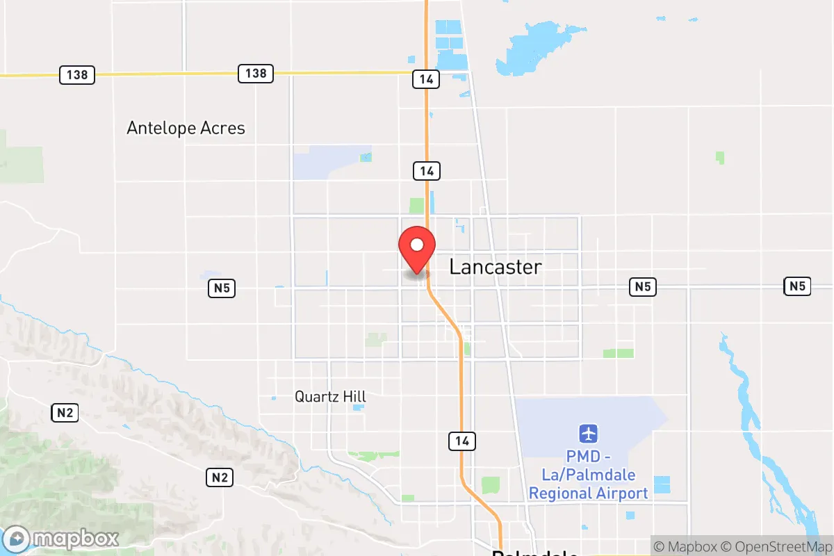
Lancaster, California, presents a complex strategic picture for the conservative prepper or survivalist. Its location at the western edge of the Mojave Desert, roughly 70 miles north of downtown Los Angeles, offers a critical buffer zone from the immediate chaos of a major metropolitan collapse, yet it remains close enough to be affected by fallout, refugee flows, and supply chain disruptions. The city’s resilience is a double-edged sword: its high desert climate and relative isolation provide natural defensive advantages, but its dependence on distant water sources and proximity to high-value military and infrastructure targets introduce significant vulnerabilities that any serious relocator must weigh.
Geographic position and natural defensive advantages in the Antelope Valley
Lancaster’s primary strategic asset is its geography. Situated on the floor of the Antelope Valley at an elevation of roughly 2,400 feet, the area offers a natural chokepoint for anyone approaching from the south. The San Gabriel Mountains form a formidable barrier, with only a few major passes—the Grapevine (I-5) and the Antelope Valley Freeway (CA-14)—providing direct access from the Los Angeles basin. In a scenario of mass evacuation or civil unrest, these passes would become gridlocked or easily defended, giving residents a significant time advantage. The surrounding terrain is open, arid, and sparsely populated, offering long sightlines and limited cover for any hostile approach. This is not a place where urban chaos can easily spill over undetected. The dry climate also mitigates many of the disease and decay issues that plague wetter regions after a breakdown, and the abundant sunshine makes solar power a highly viable off-grid energy solution. For a relocator seeking a defensible position with a clear view of the horizon, the high desert around Lancaster provides a solid foundation.
Risks, exposures, and proximity to high-value fallout and infrastructure targets
The same proximity to Los Angeles that provides economic opportunity is the area’s greatest strategic liability. Lancaster sits within the blast and fallout radius of several critical infrastructure nodes. Edwards Air Force Base, a primary test and training center for the U.S. Air Force, is only about 20 miles east—a high-priority target in any major conflict. Palmdale’s Air Force Plant 42, a key aerospace manufacturing and maintenance hub, is even closer, roughly 10 miles southeast. In a nuclear exchange or large-scale conventional attack, these facilities would be primary targets, and Lancaster would face significant fallout exposure depending on wind patterns. Furthermore, the city is a major commuter hub for the Los Angeles area, with thousands of residents traveling daily via the Antelope Valley Freeway. In a sudden crisis, this population would be trapped, and the resulting refugee flow northward could overwhelm local resources. The area’s water supply is also a vulnerability: Lancaster relies heavily on the California Aqueduct and the State Water Project, both of which are vulnerable to earthquake damage, sabotage, or operational failure. A prolonged drought or infrastructure collapse would leave the city critically short of water, as local groundwater is already depleted and brackish in many areas. For the prepper, these are not abstract risks—they are concrete, calculable threats that demand serious mitigation planning.
Practical resilience for a relocator: food, water, energy, and defensibility
For a single individual or family serious about self-sufficiency, Lancaster offers a mixed bag. Water is the single greatest challenge. The average annual rainfall is less than 7 inches, and the local aquifer is overdrafted and increasingly saline. A well is possible but expensive and uncertain; rainwater harvesting is minimal. Any long-term plan must include either a reliable connection to the municipal supply (which is vulnerable) or a serious investment in water storage and purification—think 55-gallon drums, Berkey filters, and a plan for hauling water from more reliable sources. Food production is limited by the harsh climate: short growing seasons, high winds, and poor soil mean that traditional gardening is difficult. However, the area is a major agricultural producer for alfalfa and some row crops, meaning local food supplies could be leveraged in a crisis if you have the means to trade or barter. Energy is a bright spot: the high desert receives over 280 sunny days per year, making solar panels a highly effective investment. Battery storage and a backup generator (preferably diesel or propane) are essential for off-grid capability. Defensibility is moderate. A well-chosen property on the outskirts—with a clear view of approach routes, a perimeter fence, and a hardened structure—can be made quite secure. The open terrain works against surprise attacks, but it also means you are visible. Community is a wildcard: Lancaster has a strong military and aerospace presence, which often correlates with a disciplined, self-reliant population. However, it also has significant pockets of poverty and crime, particularly in the older, denser parts of town. Property crime rates in Lancaster are roughly double the national average, so a rural or semi-rural location is strongly advised over an in-town residence.
The overall strategic picture for Lancaster is one of calculated risk. It offers a genuine buffer from the immediate collapse of a major urban center, with defensible terrain and excellent solar potential. But the vulnerabilities—water scarcity, proximity to high-value military targets, and the risk of being overwhelmed by refugees from the south—are serious and cannot be ignored. For the conservative prepper who is willing to invest heavily in water storage, off-grid energy, and a hardened rural property, Lancaster can be a viable base of operations. For those seeking a low-maintenance, low-risk retreat, the high desert’s harsh realities may prove too demanding. This is not a place for the unprepared; it is a place for the disciplined strategist who understands that survival in a fractured America requires both a strong perimeter and a clear-eyed assessment of the threats on the horizon.
* Values derived from national, state, county, city and local statistics and may differ in a specific area. Last updated: 2026-04-24T14:31:54.000Z
Narrative content on this page is AI-generated and may contain mistakes. Verify any details that matter before acting on them.
ReloMaps may earn a commission from affiliate links at no extra cost to you.