
Photo: Wikipedia
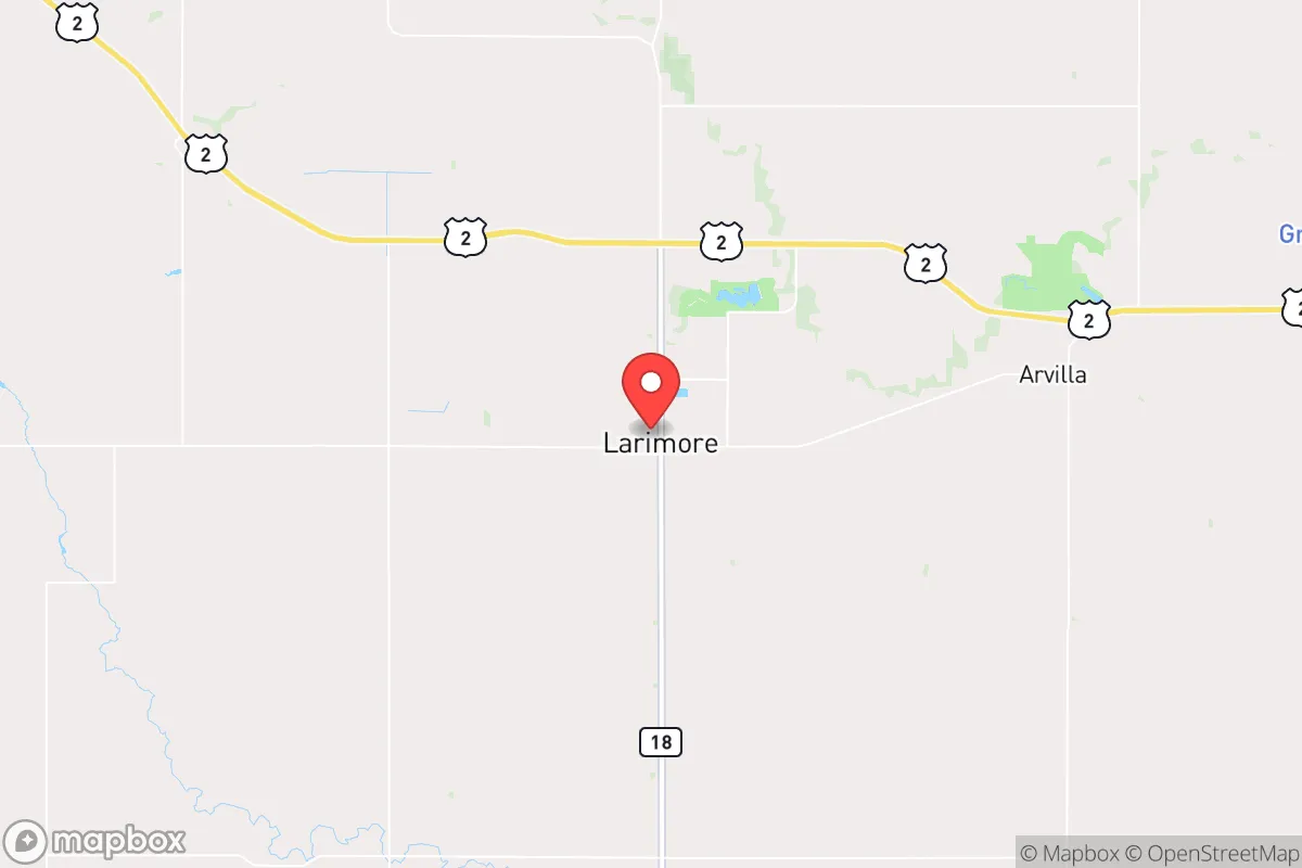
Strategic Assessment of Larimore, ND
Workable tactical position. Some exposure to population density or targets, but generally defensible in a crisis.
What does the Strategic Assessment tell us?
Our Strategic Assessment grades tactical survivability of an area. Major population centers, military targets, fallout zones, natural disasters, and border exposure all drive risk — lower exposure means a more defensible position in a crisis.
This is heavily inspired by Joel Skousen's Strategic Relocation book. Highly recommended you checkout the book ($)What does this tell us?
Our Strategic Assessment grades tactical survivability of an area. Major population centers, military targets, fallout zones, natural disasters, and border exposure all drive risk — lower exposure means a more defensible position in a crisis.
This is heavily inspired by Joel Skousen's Strategic Relocation book. Highly recommended you checkout the book ($)Strategic Pillars

Key Distances
Regional Safe Places
Below is our recommended "safe zones" in North Dakota and the surrounding area based on our strategic heuristics. For most people, it's unrealistic to live in a “safe zone” full-time due to work, family or other personal reasons. They tend to be more rural. However, many of these areas are perfect for second homes and retreat properties that double as a vacation home or even a short-term rental.
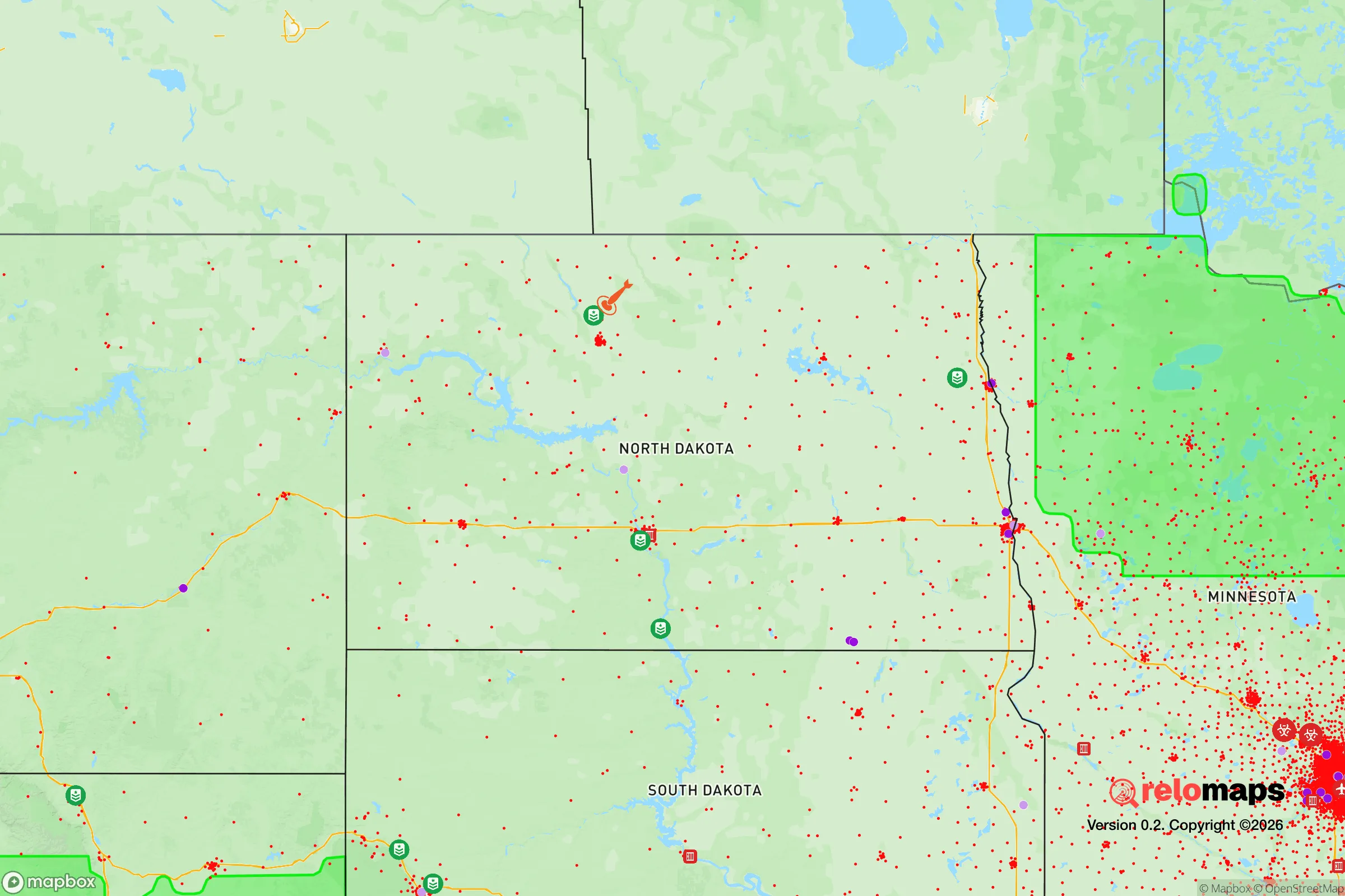
Important Note: For informational purposes only. This does not mean nothing bad ever happens in the green zones. Please use common sense. This is based on public data and modeled with AI. We tried to take a conservative approach but mistakes happen. We update this regularly as new information becomes available.
Solar Generator Recommendations
Backup power matters more here than in safer locations. We've picked three solar generators across budgets and capacity tiers — start with the budget unit if you only need a few essentials, or step up if you want to run a fridge and HVAC for days at a time.

Jackery Portable Power Station Explorer 300
Budget OptionPower on the Go: Weighing only 11 lbs, it's convenient to set up and store with book-sized foldable solar panels

BLUETTI Portable Power Station AC180
Designed for both indoor and outdoor scenarios, AC180 is highly capable as it has a robost capacity and continuous output power.

EF ECOFLOW DELTA Pro Ultra Power Station
Upgraded PickEcoFlow DELTA Pro Ultra is a whole-home energy system designed to grow with your family. Integrated with the Smart Home Panel 2, it scales to meet your evolving energy needs — keeping your home powered, intelligent, and secure through every stage of life.
We earn a commission, at no additional cost to you.
Strategic Assessment Analysis
Larimore, North Dakota, offers a compelling strategic position for those prioritizing resilience and self-sufficiency in an increasingly uncertain national landscape. Located in Grand Forks County, roughly 20 miles west of Grand Forks and 80 miles north of Fargo, this small agricultural town of roughly 1,300 people sits on the edge of the Red River Valley, providing a blend of flat, fertile farmland and access to the larger regional infrastructure without being directly exposed to the risks of a major urban center. For a relocator operating from a prepper or survivalist mindset, Larimore’s key advantage is its distance from high-density population zones and its position within a state known for low crime, strong community ties, and a culture of self-reliance, making it a viable base for long-term preparedness.
Geographic position and natural advantages for long-term preparedness
Larimore’s location in the northeastern part of North Dakota places it within a region that is geographically isolated from the most volatile corridors of the United States. The town is situated on the eastern edge of the Drift Prairie, a transition zone between the Red River Valley and the rolling hills to the west, which provides slightly elevated ground compared to the flood-prone valley floor. This elevation reduces the risk of catastrophic flooding from the Red River, a recurring threat in Grand Forks and Fargo, while still offering access to the rich agricultural soils of the valley. The area’s natural advantages include abundant surface water from the nearby Turtle River and numerous small lakes within a 30-minute drive, such as Lake Ardoch and Lake Sarah, which can serve as emergency water sources. The climate is harsh—winters are long, cold, and snowy, with average January lows near -5°F—but this severity acts as a natural deterrent to transient populations and reduces the likelihood of large-scale civil unrest during warmer months. The surrounding landscape is predominantly flat, open farmland, which offers clear lines of sight and makes it difficult for any large, organized threat to approach undetected. For a relocator, the ability to grow food in the fertile soil, combined with low population density (Grand Forks County has about 67 people per square mile, and Larimore itself is far lower), creates a defensible buffer zone that is rare in the Lower 48.
Risks, exposures, and proximity to fallout-relevant landmarks
No strategic assessment is complete without acknowledging the risks, and Larimore is not without exposure. The most significant concern is its proximity to Grand Forks Air Force Base (GFAFB), located roughly 15 miles southeast of town. GFAFB is home to the 319th Reconnaissance Wing, operating RQ-4 Global Hawk drones, and while it is not a primary nuclear missile field, it remains a high-value military target in a major conflict scenario. The base’s role in intelligence, surveillance, and reconnaissance makes it a potential first-strike or secondary-strike target, and fallout patterns from a strike on GFAFB could affect Larimore depending on wind direction. Additionally, the town lies about 80 miles from the Canadian border, which, while offering an escape route, also places it near a major international boundary that could become a chokepoint during a national emergency. The nearby city of Grand Forks (population ~55,000) is a regional hub with a university, hospital, and rail infrastructure, but its size also means it could become a focal point for civil unrest, resource competition, or disease spread. Larimore’s distance from Grand Forks (20 miles) is a double-edged sword: close enough to access supplies and medical care, but far enough to avoid the worst of urban collapse. The area also sits within the broader Red River Valley, which is prone to spring flooding, though Larimore’s slight elevation mitigates this compared to low-lying communities. For a relocator, the key takeaway is that while Larimore avoids the worst fallout risks of a major city like Minneapolis or Chicago, the presence of GFAFB and the proximity to a mid-sized city introduce moderate strategic vulnerabilities that must be factored into any long-term plan.
Practical resilience for a relocator: food, water, energy, and defensibility
For a relocator focused on practical self-sufficiency, Larimore offers a strong baseline. The town is surrounded by some of the most productive agricultural land in the United States, with corn, soybeans, wheat, and sugar beets as primary crops. This means local food production is robust, and the presence of grain elevators, farm supply co-ops, and small-scale livestock operations provides opportunities for direct sourcing or barter. Water availability is good: the Turtle River runs through the area, and the shallow aquifer beneath the Red River Valley provides reliable well water, though testing for agricultural runoff is advisable. Most homes in the area have private wells or access to municipal water from the Larimore Water Treatment Plant, which draws from groundwater sources. Energy resilience is a mixed picture. North Dakota is a major energy producer—the Bakken oil fields are 200 miles west—but Larimore itself relies on the regional grid, which is vulnerable to winter storms and ice events. However, the prevalence of farmsteads and rural properties means that many residents already have backup generators, propane tanks, and wood-burning stoves, making it easier for a relocator to integrate into a self-sufficient lifestyle. Defensibility is a strong point: the town’s small size means that a tight-knit community can be established quickly, and the open terrain allows for early warning of any approaching threats. The local law enforcement presence is minimal (Grand Forks County Sheriff’s Office covers the area), but the culture of mutual aid and firearm ownership is high, consistent with North Dakota’s strong Second Amendment traditions. For a relocator, the ability to grow food, access water, and rely on a community of like-minded individuals makes Larimore a practical choice for weathering both short-term disasters and long-term societal decline.
The overall strategic picture for Larimore, North Dakota, is one of moderate-to-high resilience with specific, manageable vulnerabilities. It is not a remote bunker location—it is close enough to a military target and a regional city to require active monitoring and contingency planning—but it offers a rare combination of agricultural self-sufficiency, low population density, and a cultural ethos of independence that aligns with a conservative, prepper-oriented mindset. For a single individual or a family looking to relocate to a place where they can build a sustainable, defensible life away from the chaos of urban America, Larimore represents a solid, if not perfect, option. The key is to treat it as a base of operations: invest in a property with a well, a garden, and backup power; establish relationships with local farmers and tradespeople; and maintain a low profile. In a world where the state of the country feels increasingly fragile, Larimore offers a quiet, practical foundation for those who want to be prepared for whatever comes next.
* Values derived from national, state, county, city and local statistics and may differ in a specific area. Last updated: 2026-04-19T07:19:21.000Z
Narrative content on this page is AI-generated and may contain mistakes. Verify any details that matter before acting on them.
ReloMaps may earn a commission from affiliate links at no extra cost to you.