Photo: Wikipedia
Strategic Assessment of Laurel, DE
Multiple tactical vulnerabilities. Population density, target proximity, or disaster risk are likely compounding. A retreat property and exit planning is required.
What does the Strategic Assessment tell us?
Our Strategic Assessment grades tactical survivability of an area. Major population centers, military targets, fallout zones, natural disasters, and border exposure all drive risk — lower exposure means a more defensible position in a crisis.
This is heavily inspired by Joel Skousen's Strategic Relocation book. Highly recommended you checkout the book ($)What does this tell us?
Our Strategic Assessment grades tactical survivability of an area. Major population centers, military targets, fallout zones, natural disasters, and border exposure all drive risk — lower exposure means a more defensible position in a crisis.
This is heavily inspired by Joel Skousen's Strategic Relocation book. Highly recommended you checkout the book ($)Strategic Pillars

Key Distances
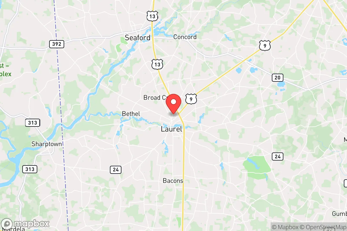
Regional Safe Places
Below is our recommended "safe zones" in Delaware and the surrounding area based on our strategic heuristics. For most people, it's unrealistic to live in a “safe zone” full-time due to work, family or other personal reasons. They tend to be more rural. However, many of these areas are perfect for second homes and retreat properties that double as a vacation home or even a short-term rental.


Important Note: For informational purposes only. This does not mean nothing bad ever happens in the green zones. Please use common sense. This is based on public data and modeled with AI. We tried to take a conservative approach but mistakes happen. We update this regularly as new information becomes available.
Solar Generator Recommendations
Backup power matters more here than in safer locations. We've picked three solar generators across budgets and capacity tiers — start with the budget unit if you only need a few essentials, or step up if you want to run a fridge and HVAC for days at a time.

Jackery Portable Power Station Explorer 300
Budget OptionPower on the Go: Weighing only 11 lbs, it's convenient to set up and store with book-sized foldable solar panels

BLUETTI Portable Power Station AC180
Designed for both indoor and outdoor scenarios, AC180 is highly capable as it has a robost capacity and continuous output power.

EF ECOFLOW DELTA Pro Ultra Power Station
Upgraded PickEcoFlow DELTA Pro Ultra is a whole-home energy system designed to grow with your family. Integrated with the Smart Home Panel 2, it scales to meet your evolving energy needs — keeping your home powered, intelligent, and secure through every stage of life.
We earn a commission, at no additional cost to you.
Strategic Assessment Analysis
Laurel, Delaware, offers a strategic blend of rural seclusion and practical access that appeals to those prioritizing long-term resilience. Positioned in western Sussex County, this small town of roughly 4,500 residents sits far enough from the I-95 corridor to avoid the immediate fallout of a major urban crisis, yet remains within a two-hour drive of essential supply routes and medical facilities in Salisbury, MD, and Dover, DE. For a relocator focused on self-sufficiency and security, Laurel’s low population density, agricultural base, and distance from high-risk targets like Washington, D.C. (about 120 miles) and Philadelphia (about 130 miles) make it a credible base for weathering societal disruptions.
Geographic position and natural advantages for long-term security
Laurel’s location in the Delmarva Peninsula provides a natural buffer against cascading failures from coastal or metropolitan disasters. The town sits on the Nanticoke River, a tributary of the Chesapeake Bay, offering a freshwater source and potential for small-scale watercraft evacuation or supply movement if road networks become compromised. The surrounding landscape is flat, heavily agricultural, and dotted with woodlots—ideal for small-scale farming, livestock, and rainwater catchment. The area’s mild climate and 200-day growing season reduce reliance on external food chains, a critical advantage when supply lines falter. Unlike inland regions prone to drought or wildfire, Laurel’s proximity to the Atlantic moderates temperature extremes, though it does face hurricane and nor’easter risks. The Delmarva’s relative isolation—bounded by the Chesapeake Bay and Atlantic Ocean—means that only two major road bridges (the Chesapeake Bay Bridge and the Delaware Memorial Bridge) connect it to the mainland, a vulnerability in mass evacuation scenarios but also a chokepoint that can be monitored or defended in a grid-down situation.
Risks, exposures, and proximity to fallout-relevant landmarks
No location is immune to risk, and Laurel’s strategic profile includes several exposures that a prepper must account for. The most immediate concern is proximity to the Indian River Power Plant (about 25 miles northeast), a coal and natural gas facility that, while not nuclear, could become a target for sabotage or a source of hazardous material release during civil unrest. The nearby Perryman Generating Station (about 30 miles north, in Maryland) adds another industrial risk. More critically, Laurel lies within 100 miles of the Salem and Hope Creek nuclear plants in New Jersey (across Delaware Bay), meaning a major incident there could deposit fallout across the Delmarva depending on wind patterns. The town’s flat terrain offers no natural shielding from airborne contaminants, so a prepper must plan for shelter-in-place with HEPA filtration and sealed rooms. On the human threat side, Laurel’s location along U.S. Route 13—a primary north-south artery on the peninsula—makes it a potential chokepoint for refugee flow during a Baltimore or D.C. evacuation. Sussex County’s population has grown 15% since 2020, driven by retirees and remote workers, increasing competition for local resources in a crisis. The county’s poverty rate hovers around 12%, and while not extreme, it means a segment of the population may lack the reserves to weather prolonged disruptions, potentially leading to localized unrest.
Practical resilience for a relocator: food, water, energy, and defensibility
For a single individual or family looking to establish a resilient homestead, Laurel offers several concrete advantages. Agricultural land remains affordable relative to the Northeast, with undeveloped parcels available for $5,000–$10,000 per acre as of 2025, allowing for a sizable garden, orchard, and small livestock operation. The Nanticoke River and its tributaries provide surface water for irrigation and emergency use, though well drilling is recommended for a reliable, contamination-free supply—expect costs of $5,000–$12,000 for a residential well. The area’s high water table (typically 10–20 feet deep) makes well installation straightforward, and the sandy loam soil drains well for septic systems. Energy resilience is achievable: net metering policies in Delaware allow solar panel owners to sell excess power back to the grid, and the region’s 4.5 peak sun hours per day make solar a viable primary source. Battery storage (e.g., Tesla Powerwall or DIY lithium setups) can provide backup for critical loads. For defensibility, Laurel’s rural character means properties often have setbacks of 50–100 feet from the road, with mature tree lines offering natural screening. The local sheriff’s office (Sussex County) has a visible presence but limited rapid-response capability in outlying areas, so a relocator should plan for neighborhood watch networks and personal security measures—motion lights, reinforced doors, and a well-stocked armory consistent with Delaware’s relatively permissive firearm laws (no permit required for open carry, concealed carry with a permit). The town’s small size means that community ties are essential for mutual aid; joining local churches, volunteer fire departments, or farm co-ops can build the trust needed for coordinated defense.
The overall strategic picture for Laurel, DE, is one of moderate promise tempered by realistic vulnerabilities. It is not a remote mountain redoubt—it sits on a peninsula with limited egress and within striking distance of major population centers. But for a relocator who values affordable land, a long growing season, and a low-key community that leans conservative (Sussex County voted +18 R in 2024), it provides a workable base for building a resilient lifestyle. The key is to treat Laurel as a launch point for self-sufficiency, not a final fortress. Stockpile supplies for 90 days, develop off-grid water and power, and cultivate relationships with neighbors who share your mindset. The risks—from nuclear fallout to refugee flows—are real but manageable with preparation. In a world where coastal cities and political centers are increasingly fragile, Laurel offers a quiet, defensible corner of the Eastern Seaboard where a determined individual or family can ride out the storm.
* Values derived from national, state, county, city and local statistics and may differ in a specific area. Last updated: 2026-04-29T22:48:57.000Z
Narrative content on this page is AI-generated and may contain mistakes. Verify any details that matter before acting on them.
ReloMaps may earn a commission from affiliate links at no extra cost to you.