Photo: Wikipedia
Strategic Assessment of Lees Summit, MO
Meaningful friction. Expect exposure to either population pressure, blast zones, or natural disaster risk. Consider buying a retreat property.
What does the Strategic Assessment tell us?
Our Strategic Assessment grades tactical survivability of an area. Major population centers, military targets, fallout zones, natural disasters, and border exposure all drive risk — lower exposure means a more defensible position in a crisis.
This is heavily inspired by Joel Skousen's Strategic Relocation book. Highly recommended you checkout the book ($)What does this tell us?
Our Strategic Assessment grades tactical survivability of an area. Major population centers, military targets, fallout zones, natural disasters, and border exposure all drive risk — lower exposure means a more defensible position in a crisis.
This is heavily inspired by Joel Skousen's Strategic Relocation book. Highly recommended you checkout the book ($)Strategic Pillars

Key Distances
Regional Safe Places
Below is our recommended "safe zones" in Missouri and the surrounding area based on our strategic heuristics. For most people, it's unrealistic to live in a “safe zone” full-time due to work, family or other personal reasons. They tend to be more rural. However, many of these areas are perfect for second homes and retreat properties that double as a vacation home or even a short-term rental.


Important Note: For informational purposes only. This does not mean nothing bad ever happens in the green zones. Please use common sense. This is based on public data and modeled with AI. We tried to take a conservative approach but mistakes happen. We update this regularly as new information becomes available.
Solar Generator Recommendations
Backup power matters more here than in safer locations. We've picked three solar generators across budgets and capacity tiers — start with the budget unit if you only need a few essentials, or step up if you want to run a fridge and HVAC for days at a time.

Jackery Portable Power Station Explorer 300
Budget OptionPower on the Go: Weighing only 11 lbs, it's convenient to set up and store with book-sized foldable solar panels

BLUETTI Portable Power Station AC180
Designed for both indoor and outdoor scenarios, AC180 is highly capable as it has a robost capacity and continuous output power.

EF ECOFLOW DELTA Pro Ultra Power Station
Upgraded PickEcoFlow DELTA Pro Ultra is a whole-home energy system designed to grow with your family. Integrated with the Smart Home Panel 2, it scales to meet your evolving energy needs — keeping your home powered, intelligent, and secure through every stage of life.
We earn a commission, at no additional cost to you.
Strategic Assessment Analysis
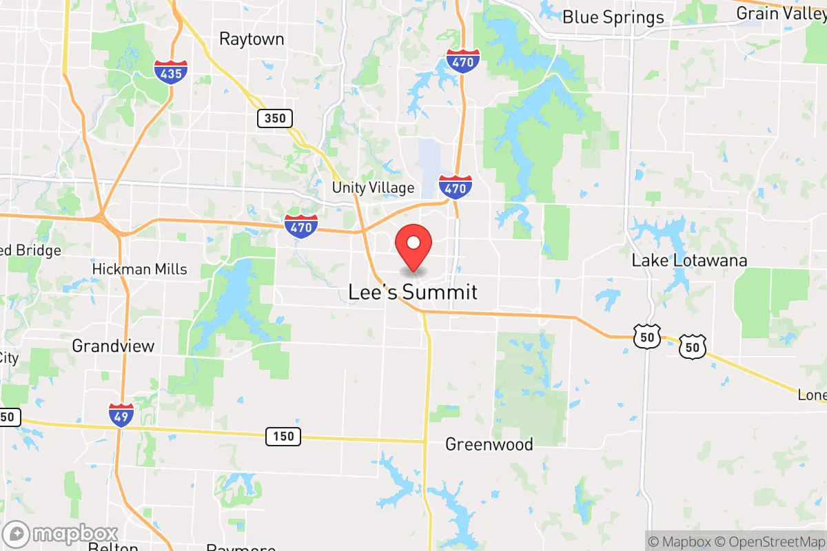
Lee’s Summit, Missouri, sits in a strategic sweet spot that resilience-minded relocators should take seriously: close enough to Kansas City’s economic engine to sustain jobs and infrastructure, but far enough out to avoid the worst of urban collapse scenarios. With a population hovering around 105,000 and steady growth driven by families and professionals, the city offers a suburban buffer that many preppers find appealing. Its location along the I-70 and I-470 corridors provides solid evacuation routes, while the surrounding rural landscape of Jackson and Cass counties gives you room to breathe if things go sideways. For a conservative audience weighing long-term stability, Lee’s Summit presents a mixed bag—real advantages in geography and community, but also real exposures tied to its proximity to a major metro area and critical infrastructure.
Geographic position and natural advantages for long-term stability
Lee’s Summit sits on the western edge of the Missouri Ozarks, a region known for its rolling hills, limestone bedrock, and abundant groundwater. That geology matters: the area is less prone to the kind of catastrophic flooding that plagues river towns like St. Louis or Kansas City’s industrial bottoms. The city’s elevation—roughly 1,000 feet above sea level—keeps it above the floodplains of the Missouri and Blue rivers, a practical advantage if climate-driven weather events become more erratic. The surrounding countryside offers decent agricultural potential, with fertile loam soils that can support small-scale farming or gardening, a key consideration for anyone planning to supplement food supplies during disruptions. The region’s four-season climate means you can grow cool-weather crops in spring and fall, though summers can be hot and humid, requiring reliable water storage. Natural water sources include Longview Lake and the Little Blue River, both within a short drive, but neither is a guaranteed year-round supply without proper filtration and access rights. For a relocator, the biggest natural plus is the area’s position: far enough from the New Madrid Seismic Zone’s worst-case shaking (about 300 miles east) and outside the direct blast radius of any major nuclear target, though that’s a relative comfort we’ll get into shortly.
Risks, exposures, and proximity to fallout-relevant landmarks
Here’s where the prepper calculus gets serious. Lee’s Summit is roughly 20 miles southeast of downtown Kansas City, a metro area of 2.2 million people that hosts a major FedEx hub, a BNSF rail yard, and several defense-adjacent industries. In a mass-casualty event—whether from a coordinated attack, a dirty bomb, or a major industrial accident—that proximity means you’re in the fallout shadow. The prevailing winds in the region blow from the southwest to the northeast, so a strike on Kansas City’s central business district or the Whiteman Air Force Base (about 60 miles east) could push contamination toward Lee’s Summit depending on the day’s weather. The city itself is home to a few potential secondary targets: the Lee’s Summit Medical Center and the Missouri Highway Patrol’s regional headquarters could become chokepoints during unrest, drawing crowds or becoming targets for those looking to disrupt emergency services. The nearby Lake City Army Ammunition Plant in Independence (about 15 miles north) is a high-risk facility—it’s one of the largest small-caliber ammunition producers in the U.S., and any explosion or attack there would send shockwaves through the region. For a relocator, the biggest exposure is the I-70 corridor, which runs just north of the city. In a mass evacuation scenario, that highway becomes a parking lot, and the secondary routes (like MO-291 and MO-150) will clog fast. The city’s growth has also pushed suburban sprawl into former farmland, meaning you’ve got more neighbors to compete with for resources if supply chains snap.
Practical resilience for a relocator: food, water, energy, and defensibility
Let’s break down the nuts and bolts of daily survival in Lee’s Summit. Water: The city draws from the Missouri River via a treatment plant in Kansas City, which means your tap water is vulnerable to upstream contamination—chemical spills, agricultural runoff, or sabotage. A well on your property is a major advantage here, but not all lots have access; the limestone bedrock can make drilling expensive and unpredictable. Food: Local grocery stores like Hy-Vee and Price Chopper are well-stocked in normal times, but they rely on just-in-time delivery from regional distribution centers. The Lee’s Summit Farmers Market (April to October) is a decent source for local produce, but don’t count on it during a crisis. For long-term food security, you’ll want to establish relationships with farmers in Cass County or buy land with gardening space. Energy: Evergy provides electricity, and the grid here is moderately reliable—outages happen during ice storms and summer thunderstorms, but they’re usually restored within 24 hours. Solar panels are viable, with the region averaging about 200 sunny days per year, but you’ll need battery storage to handle winter cloud cover. Natural gas is widely available for heating, but a grid-down scenario means you’re reliant on propane tanks or wood stoves. Defensibility: Lee’s Summit is a suburban grid of cul-de-sacs and arterial roads, which makes it hard to secure a perimeter. The city’s police department is well-funded and responsive (about 1.5 officers per 1,000 residents), but during widespread civil unrest, they’ll be stretched thin. Your best bet is a property on the outskirts—think unincorporated areas near Greenwood or Lone Jack—where you have more land, fewer neighbors, and better sightlines. The local gun culture is strong, with several ranges and gun shops (like Frontier Justice) in the area, and Missouri’s constitutional carry law means you can defend yourself without bureaucratic hurdles. But remember: in a suburban setting, your neighbors are your first line of defense or your biggest liability. Building a trusted network of like-minded families is as important as stockpiling ammo.
The overall strategic picture for Lee’s Summit is one of calculated trade-offs. It’s not a remote bunker location—you’re still within a day’s walk of a major city, and the fallout risks from Kansas City and the Lake City plant are real. But for a relocator who wants to maintain a professional career while building resilience, it offers a workable middle ground. The community is politically mixed but leans conservative in the outer suburbs, with a strong church presence and a culture of self-reliance that aligns with prepper values. The cost of living is reasonable (median home price around $350,000 as of 2025), and the schools are solid, which matters if you’re raising kids who need to understand why Dad has a basement full of MREs. If you’re willing to invest in off-grid water, a backup power system, and a network of trusted neighbors, Lee’s Summit can be a launchpad for a resilient lifestyle—just don’t mistake it for a bug-out location. The smart play is to treat it as a base of operations, with a secondary rural property further east in the Ozarks for when the SHTF. That dual-location strategy gives you the best of both worlds: the economic stability of the suburbs and the escape hatch of the backcountry. In a world where the next crisis is always around the corner, that’s about as good as it gets in the Midwest.
* Values derived from national, state, county, city and local statistics and may differ in a specific area. Last updated: 2026-04-30T07:17:00.000Z
Narrative content on this page is AI-generated and may contain mistakes. Verify any details that matter before acting on them.
ReloMaps may earn a commission from affiliate links at no extra cost to you.