Photo: Wikipedia
Strategic Assessment of Litchfield, CT
Multiple tactical vulnerabilities. Population density, target proximity, or disaster risk are likely compounding. A retreat property and exit planning is required.
What does the Strategic Assessment tell us?
Our Strategic Assessment grades tactical survivability of an area. Major population centers, military targets, fallout zones, natural disasters, and border exposure all drive risk — lower exposure means a more defensible position in a crisis.
This is heavily inspired by Joel Skousen's Strategic Relocation book. Highly recommended you checkout the book ($)What does this tell us?
Our Strategic Assessment grades tactical survivability of an area. Major population centers, military targets, fallout zones, natural disasters, and border exposure all drive risk — lower exposure means a more defensible position in a crisis.
This is heavily inspired by Joel Skousen's Strategic Relocation book. Highly recommended you checkout the book ($)Strategic Pillars

Key Distances
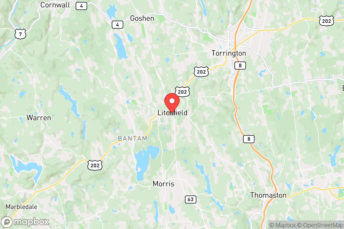
Regional Safe Places
Below is our recommended "safe zones" in Connecticut and the surrounding area based on our strategic heuristics. For most people, it's unrealistic to live in a “safe zone” full-time due to work, family or other personal reasons. They tend to be more rural. However, many of these areas are perfect for second homes and retreat properties that double as a vacation home or even a short-term rental.


Important Note: For informational purposes only. This does not mean nothing bad ever happens in the green zones. Please use common sense. This is based on public data and modeled with AI. We tried to take a conservative approach but mistakes happen. We update this regularly as new information becomes available.
Solar Generator Recommendations
Backup power matters more here than in safer locations. We've picked three solar generators across budgets and capacity tiers — start with the budget unit if you only need a few essentials, or step up if you want to run a fridge and HVAC for days at a time.

Jackery Portable Power Station Explorer 300
Budget OptionPower on the Go: Weighing only 11 lbs, it's convenient to set up and store with book-sized foldable solar panels

BLUETTI Portable Power Station AC180
Designed for both indoor and outdoor scenarios, AC180 is highly capable as it has a robost capacity and continuous output power.

EF ECOFLOW DELTA Pro Ultra Power Station
Upgraded PickEcoFlow DELTA Pro Ultra is a whole-home energy system designed to grow with your family. Integrated with the Smart Home Panel 2, it scales to meet your evolving energy needs — keeping your home powered, intelligent, and secure through every stage of life.
We earn a commission, at no additional cost to you.
Strategic Assessment Analysis
Litchfield, Connecticut, sits in a strategic sweet spot that few Northeastern locations can claim: close enough to major economic corridors to sustain a career and supply chain access, yet far enough from the dense urban cores that will become liabilities during widespread unrest or disaster. The town’s position in the Litchfield Hills—roughly 30 miles west of Hartford and 90 miles from New York City—places it outside the immediate blast radius of any major metropolitan target, while still offering a defensible, resource-rich environment. For a relocator thinking in terms of long-term resilience, Litchfield provides a rare combination of geographic insulation, natural water abundance, and a community culture that still values self-reliance and local governance.
Geographic position and natural advantages for long-term security
Litchfield’s topography is its first line of defense. The town sits on a series of rolling hills and ridges, with elevations reaching over 1,300 feet in some areas, which provides natural observation points and makes large-scale mechanized movement through the area difficult. The surrounding Litchfield Hills are part of the Appalachian foothills, offering dense forest cover, numerous streams, and a network of old farm roads that can serve as alternative routes if main highways become compromised. The Bantam River and Shepaug River watersheds run through the town, and Bantam Lake—the largest natural lake in Connecticut—lies just south, providing a reliable surface water source that is less vulnerable to contamination than municipal reservoirs fed by long pipelines. The area’s glacial till soils are well-drained and suitable for small-scale agriculture, and the local growing season, while short (roughly 140 days), is sufficient for cold-hardy crops like potatoes, root vegetables, and greens. The town’s low population density—around 8,500 residents spread over 57 square miles—means that in a crisis, competition for resources would be far less intense than in suburban sprawl zones like Danbury or Waterbury.
Risks, exposures, and proximity to fallout-relevant landmarks
No location is without vulnerabilities, and Litchfield’s are worth a hard look. The most obvious risk is its proximity to the New York City metro area—roughly 90 miles as the crow flies. While that distance puts Litchfield outside the immediate blast and thermal effects of a nuclear detonation in Manhattan, fallout patterns are highly dependent on wind direction. Prevailing winds in the region are from the west and southwest, meaning that a major event in New York or even the Indian Point nuclear facility (now decommissioned but still storing spent fuel) could push contaminated air and particles toward Litchfield within hours. The town is also within 50 miles of the Millstone Nuclear Power Station in Waterford, CT, and the Seabrook Station in New Hampshire is about 150 miles away—both are potential targets or accident sites. On the infrastructure side, Litchfield is served by a single major arterial, Route 202, which runs east-west through the town center. This road is a chokepoint; if it becomes blocked by a accident, debris, or civil unrest, egress and resupply options are limited to narrow secondary roads that can be easily clogged. The town has no major rail or air transport hub, which is a double-edged sword: it reduces the risk of being a target, but also limits evacuation capacity. Finally, Litchfield County has a history of ice storms and blizzards that can knock out power for days or weeks, and the aging electrical grid is not hardened for extended outages. A determined adversary could exploit these weather-related vulnerabilities to create chaos.
Practical resilience for a relocator: food, water, energy, and defensibility
For someone serious about self-sufficiency, Litchfield offers a workable baseline. Water is the most critical resource, and the town’s numerous streams, ponds, and the Bantam River watershed provide ample surface water. However, surface water requires treatment—boiling, filtration, or chemical purification—and during a prolonged grid-down event, reliance on hand pumps or gravity-fed systems becomes necessary. The town’s municipal water system serves the central village area, but most rural properties rely on private wells, which are generally reliable but require electricity to pump. A backup generator or solar-powered pump is a wise investment. Food production is feasible but not effortless: the soil is rocky and acidic in many areas, requiring amendment with lime and compost. The local growing season is short, so a greenhouse or cold frame extends the window significantly. Hunting and fishing are legal with licenses, and the area has healthy populations of white-tailed deer, wild turkey, and small game, plus trout in the Bantam River. For energy, Litchfield has decent solar exposure—about 4.5 peak sun hours per day on average—and many homes have southern-facing roof lines suitable for panels. Wood heating is common, and the surrounding forests provide ample firewood, though processing it requires physical labor and a chainsaw. Defensibility is a mixed bag: the town’s layout is spread out, with many homes set back from the road and surrounded by trees, which provides natural concealment and standoff. But the lack of a centralized defensive perimeter means that a small group would need to secure its own property rather than rely on a community watch. The Litchfield County Sheriff’s Office and State Police have a presence, but response times in rural areas can exceed 20 minutes, and during a widespread event, law enforcement will be stretched thin. The local gun culture is moderate—Connecticut has some of the strictest firearm laws in the country, including an assault weapons ban and magazine capacity limits—so preppers should be aware that building a serious armory is legally constrained. Still, the town’s conservative-leaning population (Litchfield voted for Trump in 2020 by a narrow margin, but the surrounding county is more reliably red) means that many residents are already armed and familiar with firearms, which can be a stabilizing factor in a crisis.
The overall strategic picture for Litchfield is one of cautious optimism for the prepared relocator. It is not a hardened bunker or a remote mountain redoubt, but it is a viable base of operations for someone who wants to be within a few hours of major economic hubs while maintaining a low profile and a defensible position. The town’s natural water resources, forest cover, and low population density give it a resilience advantage over most of Connecticut’s suburban corridor. The risks—fallout proximity, grid fragility, and legal restrictions on self-defense tools—are real but manageable with proper planning. For a conservative-leaning individual or family looking to plant roots in a place that still has a sense of community and local control, Litchfield offers a solid foundation. The key is to arrive with your own water filtration, a solar setup, a wood stove, and a network of local contacts who share your mindset. Do that, and you’ll be as prepared as anyone in the Northeast can reasonably be.
* Values derived from national, state, county, city and local statistics and may differ in a specific area. Last updated: 2026-04-21T09:21:31.000Z
Narrative content on this page is AI-generated and may contain mistakes. Verify any details that matter before acting on them.
ReloMaps may earn a commission from affiliate links at no extra cost to you.