Photo: Wikipedia
Strategic Assessment of Maple Grove, MN
Multiple tactical vulnerabilities. Population density, target proximity, or disaster risk are likely compounding. A retreat property and exit planning is required.
What does the Strategic Assessment tell us?
Our Strategic Assessment grades tactical survivability of an area. Major population centers, military targets, fallout zones, natural disasters, and border exposure all drive risk — lower exposure means a more defensible position in a crisis.
This is heavily inspired by Joel Skousen's Strategic Relocation book. Highly recommended you checkout the book ($)What does this tell us?
Our Strategic Assessment grades tactical survivability of an area. Major population centers, military targets, fallout zones, natural disasters, and border exposure all drive risk — lower exposure means a more defensible position in a crisis.
This is heavily inspired by Joel Skousen's Strategic Relocation book. Highly recommended you checkout the book ($)Strategic Pillars

Key Distances
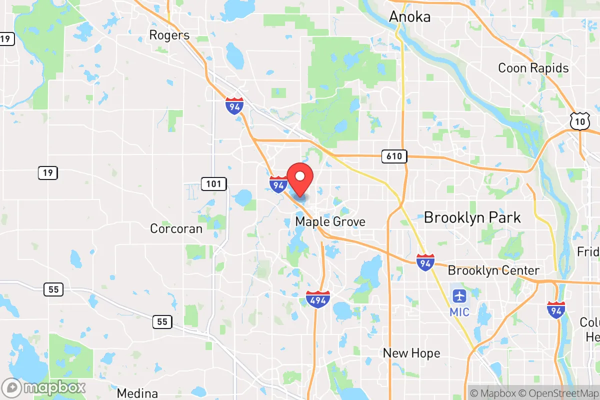
Regional Safe Places
Below is our recommended "safe zones" in Minnesota and the surrounding area based on our strategic heuristics. For most people, it's unrealistic to live in a “safe zone” full-time due to work, family or other personal reasons. They tend to be more rural. However, many of these areas are perfect for second homes and retreat properties that double as a vacation home or even a short-term rental.


Important Note: For informational purposes only. This does not mean nothing bad ever happens in the green zones. Please use common sense. This is based on public data and modeled with AI. We tried to take a conservative approach but mistakes happen. We update this regularly as new information becomes available.
Solar Generator Recommendations
Backup power matters more here than in safer locations. We've picked three solar generators across budgets and capacity tiers — start with the budget unit if you only need a few essentials, or step up if you want to run a fridge and HVAC for days at a time.

Jackery Portable Power Station Explorer 300
Budget OptionPower on the Go: Weighing only 11 lbs, it's convenient to set up and store with book-sized foldable solar panels

BLUETTI Portable Power Station AC180
Designed for both indoor and outdoor scenarios, AC180 is highly capable as it has a robost capacity and continuous output power.

EF ECOFLOW DELTA Pro Ultra Power Station
Upgraded PickEcoFlow DELTA Pro Ultra is a whole-home energy system designed to grow with your family. Integrated with the Smart Home Panel 2, it scales to meet your evolving energy needs — keeping your home powered, intelligent, and secure through every stage of life.
We earn a commission, at no additional cost to you.
Strategic Assessment Analysis
Maple Grove, Minnesota, presents a mixed strategic picture for the conservative prepper or survivalist. While its location offers genuine logistical advantages in terms of water access and regional supply chains, its proximity to a major metropolitan area and the associated risks of civil unrest, infrastructure dependency, and potential fallout targets make it a location that requires careful, sober assessment. This is not a remote retreat; it is a suburban staging ground with specific strengths and significant vulnerabilities that demand a clear-eyed plan.
Geographic position and natural advantages for long-term sustainability
Maple Grove sits in the northwest quadrant of the Twin Cities metro, roughly 20 miles from downtown Minneapolis. Its most significant natural asset is its position along the Mississippi River, which provides a reliable, large-volume water source for filtration and treatment. The city is also near the Elm Creek Park Reserve, a 4,900-acre tract of woodlands, wetlands, and prairie that offers game habitat, foraging potential, and a natural buffer zone. The region's glacial till soils are fertile, supporting small-scale agriculture, and the area's numerous lakes—including Fish Lake and Rush Lake—offer secondary water sources and fishing opportunities. The relatively flat terrain is not defensible in a tactical sense, but it does allow for efficient movement and line-of-sight observation. The climate is a double-edged sword: harsh winters provide a natural barrier to movement and can slow the spread of unrest, but they also create serious challenges for off-grid heating, food storage, and transportation. The growing season is short (roughly 150 days), so any serious food production plan must account for cold frames, greenhouses, or indoor hydroponics.
Risks, exposures, and proximity to fallout-relevant landmarks
The most glaring vulnerability is Maple Grove's proximity to the Twin Cities metroplex. Minneapolis and St. Paul are dense population centers with a history of civil unrest, including the 2020 riots that caused hundreds of millions in damage and overwhelmed local law enforcement. A major grid-down event, economic collapse, or political crisis could trigger a mass exodus from the cities, with Maple Grove lying directly along potential evacuation routes (I-94 and I-494). The city itself has a population of about 75,000, which means it is not a small, self-contained community but a suburb that would be overwhelmed by refugees. Additionally, the metro area contains multiple high-value fallout targets: the Minneapolis-St. Paul International Airport, the Mall of America (a symbolic target), major corporate HQs (Target, Best Buy, 3M), and the Xcel Energy Sherco coal plant in Becker (about 40 miles northwest). A nuclear or EMP event would render the region a high-risk zone. The city's reliance on the electrical grid and natural gas for heating is a critical weakness—a prolonged winter power outage would be life-threatening without a robust backup system. Maple Grove is also in a tornado-prone zone, with an average of 2-3 tornado warnings per year, adding a natural disaster layer to the risk profile.
Practical resilience for a relocator: food, water, energy, and defensibility
For a relocator willing to invest in hardening, Maple Grove offers some practical advantages. Water is the strongest suit: the Mississippi River is a year-round, high-volume source, and the city's municipal water comes from groundwater wells, which are less vulnerable to surface contamination than many other systems. A prepper with a Berkey filter or a well-drilling plan could secure a reliable supply. Food is a mixed bag: the city has multiple grocery stores (Cub Foods, Lunds & Byerlys, Trader Joe's) and a strong farmers' market (June-October), but these are just-in-time supply chains that would collapse within 72 hours of a disruption. Local agriculture is limited to hobby farms and community gardens; there is no significant grain or livestock production within a 10-mile radius. A serious food storage plan (6-12 months of shelf-stable goods) is non-negotiable. Energy is the weakest link: the grid is reliable in normal times, but a major event would leave most homes without heat, light, or refrigeration. Solar panels with battery backup (e.g., Tesla Powerwall or DIY lithium banks) are viable, but winter sun is limited (roughly 9 hours of daylight in December). A wood-burning stove or a propane generator with a large fuel cache is a more realistic primary backup. Defensibility is poor: Maple Grove is a typical suburban grid of cul-de-sacs and arterial roads, offering no natural chokepoints or high ground. A single-family home on a quarter-acre lot provides limited perimeter security. The best strategy is to form a neighborhood watch or mutual assistance group with like-minded neighbors, as isolated defense is nearly impossible. The city's police department is well-funded and professional, but in a widespread crisis, they would be stretched thin or absent. Community and networking: Maple Grove has a strong church presence (multiple evangelical and Catholic parishes) and a growing conservative population, which can be a foundation for building a trusted network. The city also has a robust parks system and a community center that could serve as a rallying point or distribution hub in a crisis.
The overall strategic picture for Maple Grove is one of calculated risk. It is not a survivalist's paradise—it is a suburban compromise that offers good water access and a relatively stable local economy, but sits dangerously close to a major urban center with a history of unrest and multiple high-value targets. For a single individual or family willing to invest in serious prepping—off-grid energy, water filtration, food storage, and a strong local network—Maple Grove can be a viable base of operations. But it requires constant vigilance, a well-rehearsed evacuation plan (with a secondary location 100+ miles north or west), and a realistic acceptance that the first 72 hours of any major event will be chaotic and dangerous. The conservative prepper who chooses Maple Grove must treat it as a staging ground, not a final redoubt. If you are looking for a remote, defensible, low-profile retreat, look farther north to the Iron Range or west to the Dakotas. If you need to stay near the metro for work or family, Maple Grove is one of the better suburban options—but only if you treat it as a high-risk, high-reward location that demands preparation, not complacency.
* Values derived from national, state, county, city and local statistics and may differ in a specific area. Last updated: 2026-04-24T07:37:21.000Z
Narrative content on this page is AI-generated and may contain mistakes. Verify any details that matter before acting on them.
ReloMaps may earn a commission from affiliate links at no extra cost to you.