
Photo: Wikipedia
Strategic Assessment of Mauldin, SC
Meaningful friction. Expect exposure to either population pressure, blast zones, or natural disaster risk. Consider buying a retreat property.
What does the Strategic Assessment tell us?
Our Strategic Assessment grades tactical survivability of an area. Major population centers, military targets, fallout zones, natural disasters, and border exposure all drive risk — lower exposure means a more defensible position in a crisis.
This is heavily inspired by Joel Skousen's Strategic Relocation book. Highly recommended you checkout the book ($)What does this tell us?
Our Strategic Assessment grades tactical survivability of an area. Major population centers, military targets, fallout zones, natural disasters, and border exposure all drive risk — lower exposure means a more defensible position in a crisis.
This is heavily inspired by Joel Skousen's Strategic Relocation book. Highly recommended you checkout the book ($)Strategic Pillars

Key Distances
Regional Safe Places
Below is our recommended "safe zones" in South Carolina and the surrounding area based on our strategic heuristics. For most people, it's unrealistic to live in a “safe zone” full-time due to work, family or other personal reasons. They tend to be more rural. However, many of these areas are perfect for second homes and retreat properties that double as a vacation home or even a short-term rental.


Important Note: For informational purposes only. This does not mean nothing bad ever happens in the green zones. Please use common sense. This is based on public data and modeled with AI. We tried to take a conservative approach but mistakes happen. We update this regularly as new information becomes available.
Solar Generator Recommendations
Backup power matters more here than in safer locations. We've picked three solar generators across budgets and capacity tiers — start with the budget unit if you only need a few essentials, or step up if you want to run a fridge and HVAC for days at a time.

Jackery Portable Power Station Explorer 300
Budget OptionPower on the Go: Weighing only 11 lbs, it's convenient to set up and store with book-sized foldable solar panels

BLUETTI Portable Power Station AC180
Designed for both indoor and outdoor scenarios, AC180 is highly capable as it has a robost capacity and continuous output power.

EF ECOFLOW DELTA Pro Ultra Power Station
Upgraded PickEcoFlow DELTA Pro Ultra is a whole-home energy system designed to grow with your family. Integrated with the Smart Home Panel 2, it scales to meet your evolving energy needs — keeping your home powered, intelligent, and secure through every stage of life.
We earn a commission, at no additional cost to you.
Strategic Assessment Analysis
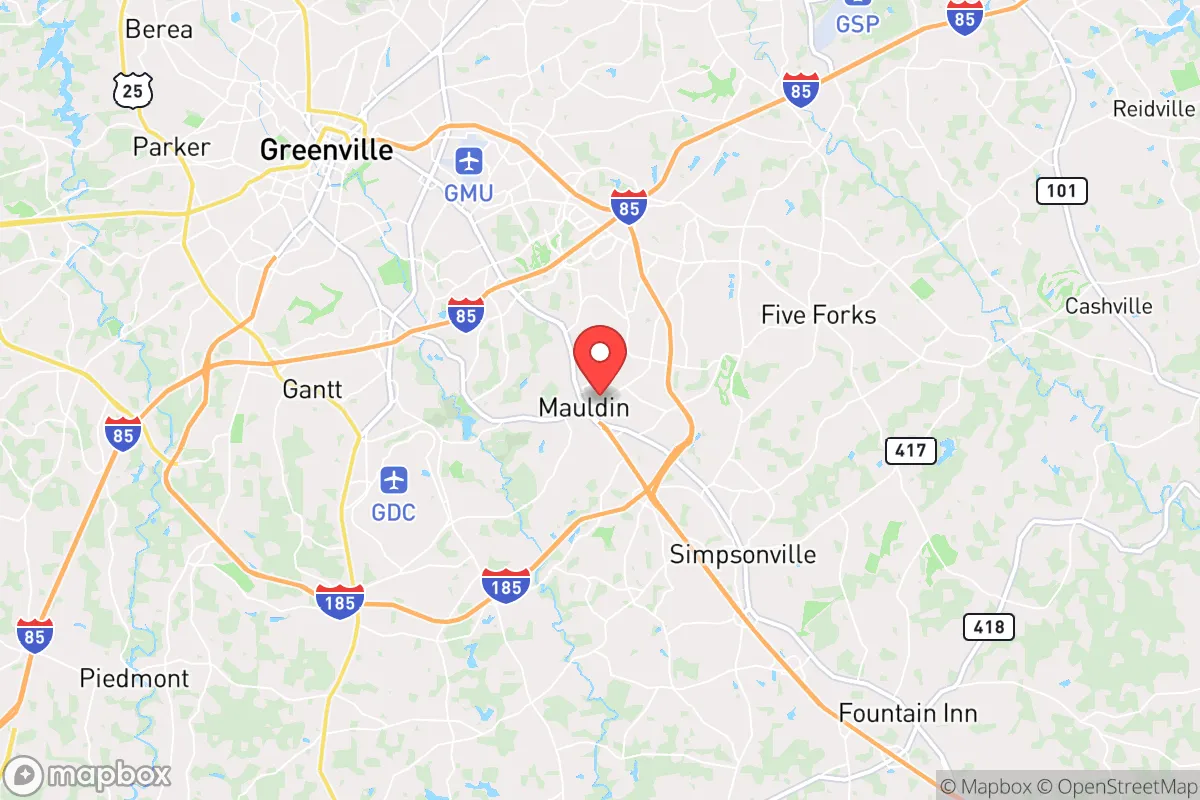
Mauldin, South Carolina, offers a strategic balance of proximity to economic infrastructure and enough separation from major urban centers to make it a viable relocation option for those prioritizing resilience and preparedness. Situated in Greenville County, roughly 10 miles southeast of downtown Greenville and 15 miles from the Greenville-Spartanburg International Airport, Mauldin provides access to jobs and supply chains without the immediate risks of a dense metropolitan core. Its location along the I-85 corridor places it within a day’s drive of Atlanta, Charlotte, and the Appalachian foothills, giving relocators both escape routes and logistical reach. For a conservative-leaning audience concerned with civic stability and self-sufficiency, Mauldin’s growth trajectory and geographic positioning warrant a careful, strategic assessment.
Geographic position and natural advantages for long-term stability
Mauldin sits in the Piedmont region of Upstate South Carolina, a zone characterized by rolling hills, moderate elevation (around 900 feet), and a climate that avoids the extremes of coastal hurricane zones and inland winter freezes. The area’s natural advantages include a reliable annual rainfall of roughly 50 inches, which supports local agriculture and groundwater recharge, and a growing season of about 220 days—long enough for substantial home gardening and small-scale farming. The proximity to the Blue Ridge Escarpment, roughly 30 miles northwest, provides a natural barrier against large-scale weather systems and offers a potential retreat zone if urban conditions deteriorate. The region’s geology is dominated by crystalline bedrock (granite and gneiss), which limits the risk of sinkholes or seismic activity and provides stable foundations for well-drilling and underground structures. For a relocator, this means the land itself is defensible and productive, with fewer natural disaster liabilities than coastal or floodplain areas.
Risks, exposures, and proximity to fallout-relevant landmarks
The primary strategic drawback of Mauldin is its proximity to several high-value targets that could become focal points during a major disruption. Greenville-Spartanburg International Airport (GSP), a regional hub with military and cargo operations, lies about 15 miles northeast—close enough that a major incident there could create secondary effects like road closures, panic-driven migration, or supply chain interruptions. The I-85 corridor itself is a critical logistics artery linking the Southeast; during a national emergency, this highway could become a chokepoint or a target for civil unrest. Additionally, the Savannah River Site (a nuclear weapons facility and waste storage complex) is roughly 100 miles south, and while that distance provides some buffer, prevailing winds and fallout patterns in a worst-case scenario could affect Upstate South Carolina depending on weather conditions. Mauldin’s growth rate—population increased by over 30% between 2010 and 2020—also means suburban sprawl is reducing the area’s natural buffer zones, with new subdivisions encroaching on farmland and woodlands. For a prepper, the key risk is not a direct strike but the cascading effects of a regional crisis: mass evacuation from Greenville or Spartanburg could overwhelm local roads, supplies, and services within hours.
Practical resilience for a relocator: food, water, energy, and defensibility
For a relocator focused on practical self-sufficiency, Mauldin offers a mixed but workable picture. Water access is the strongest asset: the area sits atop the Piedmont aquifer system, and many residential properties can support private wells at depths of 100–300 feet, with yields typically ranging from 5 to 20 gallons per minute. Municipal water comes from the Greenville Water System, which draws from the Table Rock Reservoir in the mountains—a protected watershed that is less vulnerable to contamination than surface sources in flatter terrain. Food production is feasible on lots of half an acre or more, with local soil types (primarily Cecil sandy loam) requiring amendment but capable of supporting vegetables, fruit trees, and small livestock. The Mauldin Farmers Market and nearby feed stores provide seed and supply access, though reliance on national supply chains for fertilizer and equipment is a vulnerability. Energy resilience is moderate: Duke Energy provides grid power with a history of storm-related outages (typically 2–4 per year, lasting a few hours to a day). Solar potential is good, with an average of 218 sunny days annually, but homeowners’ association restrictions in many Mauldin subdivisions limit visible panel installations. Backup generators are common among prepper-minded residents. Defensibility is the weakest category: Mauldin is a suburban bedroom community with no natural chokepoints, a grid-like street pattern, and easy access from multiple directions. A rural property on the outskirts—especially near the Reedy River or toward Simpsonville—offers better standoff distance and concealment than in-town lots. For a single individual or family, the best strategy is to secure a home on at least 2–3 acres in the unincorporated areas south of Mauldin, where zoning is looser and neighbors are farther apart.
The overall strategic picture for Mauldin is one of conditional viability. It is not a hardened retreat or a remote homestead, but it is a functional base of operations for someone who wants to maintain a professional career while building resilience incrementally. The area’s real estate market remains relatively affordable compared to the national average (median home price around $350,000 as of 2025), and the local economy—anchored by manufacturing, healthcare, and logistics—provides employment stability even during downturns. The conservative political culture of Greenville County (which voted +18 points Republican in the 2024 presidential election) aligns with the values of self-reliance and community mutual aid that underpin a prepper mindset. However, the same growth that brings jobs also brings congestion, regulation, and proximity to risk. For a relocator serious about long-term survival, Mauldin works best as a stepping stone: a place to build skills, stockpile supplies, and network with like-minded locals while scouting more remote property in the nearby mountains or rural counties like Laurens or Union. The key is to treat Mauldin not as a final destination, but as a strategic forward operating base with good logistics and a reasonable risk profile—provided you have an exit plan.
* Values derived from national, state, county, city and local statistics and may differ in a specific area. Last updated: 2026-04-30T02:47:21.000Z
Narrative content on this page is AI-generated and may contain mistakes. Verify any details that matter before acting on them.
ReloMaps may earn a commission from affiliate links at no extra cost to you.