
Photo: Wikipedia
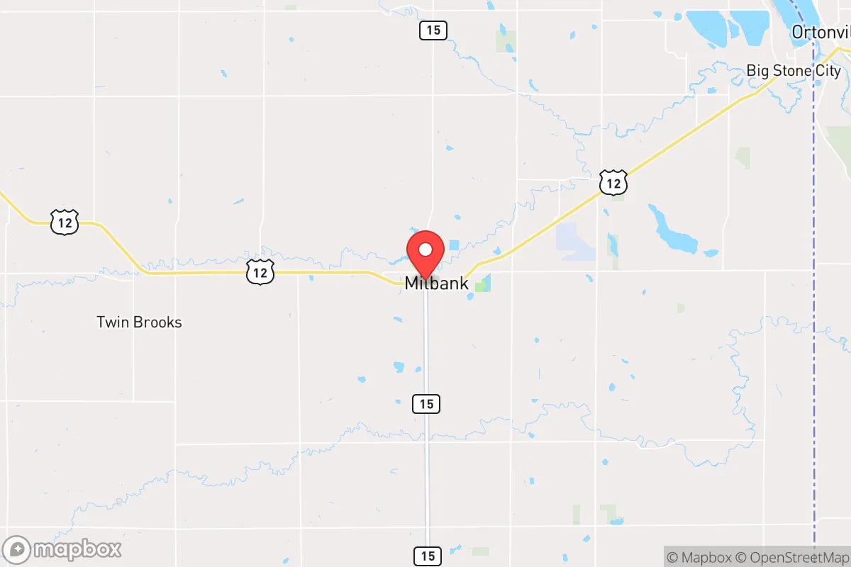
Strategic Assessment of Milbank, SD
Strong survivability profile. Good buffer from population centers, with manageable environmental and tactical risks.
What does the Strategic Assessment tell us?
Our Strategic Assessment grades tactical survivability of an area. Major population centers, military targets, fallout zones, natural disasters, and border exposure all drive risk — lower exposure means a more defensible position in a crisis.
This is heavily inspired by Joel Skousen's Strategic Relocation book. Highly recommended you checkout the book ($)What does this tell us?
Our Strategic Assessment grades tactical survivability of an area. Major population centers, military targets, fallout zones, natural disasters, and border exposure all drive risk — lower exposure means a more defensible position in a crisis.
This is heavily inspired by Joel Skousen's Strategic Relocation book. Highly recommended you checkout the book ($)Strategic Pillars

Key Distances
Regional Safe Places
Below is our recommended "safe zones" in South Dakota and the surrounding area based on our strategic heuristics. For most people, it's unrealistic to live in a “safe zone” full-time due to work, family or other personal reasons. They tend to be more rural. However, many of these areas are perfect for second homes and retreat properties that double as a vacation home or even a short-term rental.


Important Note: For informational purposes only. This does not mean nothing bad ever happens in the green zones. Please use common sense. This is based on public data and modeled with AI. We tried to take a conservative approach but mistakes happen. We update this regularly as new information becomes available.
Solar Generator Recommendations
Backup power matters more here than in safer locations. We've picked three solar generators across budgets and capacity tiers — start with the budget unit if you only need a few essentials, or step up if you want to run a fridge and HVAC for days at a time.

Jackery Portable Power Station Explorer 300
Budget OptionPower on the Go: Weighing only 11 lbs, it's convenient to set up and store with book-sized foldable solar panels

BLUETTI Portable Power Station AC180
Designed for both indoor and outdoor scenarios, AC180 is highly capable as it has a robost capacity and continuous output power.

EF ECOFLOW DELTA Pro Ultra Power Station
Upgraded PickEcoFlow DELTA Pro Ultra is a whole-home energy system designed to grow with your family. Integrated with the Smart Home Panel 2, it scales to meet your evolving energy needs — keeping your home powered, intelligent, and secure through every stage of life.
We earn a commission, at no additional cost to you.
Strategic Assessment Analysis
Milbank, South Dakota, offers a strategic combination of geographic isolation and practical infrastructure that makes it a serious contender for those prioritizing resilience and self-sufficiency. Located in Grant County, roughly 50 miles northeast of Watertown and 30 miles from the Minnesota border, this town of about 3,300 people sits far from major population centers and the vulnerabilities they carry. For a relocator with a prepper mindset, Milbank’s low population density, agricultural base, and distance from high-value targets like missile silos or major military installations provide a foundation for long-term stability in an increasingly uncertain national landscape.
Geographic position and natural advantages for long-term stability
Milbank’s location in the Coteau des Prairies region gives it a subtle but meaningful defensive edge. The area sits on a plateau that rises 200–400 feet above the surrounding plains, offering natural vantage points and slightly cooler summer temperatures. The Big Stone Lake and the Whetstone River provide surface water sources that are less likely to be contaminated by industrial runoff compared to areas near the Missouri River or the Bakken oil fields. The surrounding Grant County is dominated by row crops—corn, soybeans, and wheat—and pastureland, meaning food production is literally in the backyard. For a relocator, this means local food sourcing is viable without relying on fragile supply chains. The nearest city of any size, Watertown, is a 45-minute drive, which is far enough to avoid the daily chaos of urban collapse but close enough for occasional supply runs or medical needs. The region’s position in the Upper Midwest also places it outside the primary fallout corridors from major strategic targets like Minot Air Force Base in North Dakota or the nuclear facilities in Minnesota, though some risk remains from long-range drift.
Risks, exposures, and proximity to fallout-relevant landmarks
No location is risk-free, and Milbank has its own set of vulnerabilities that a strategic relocator must weigh. The most significant exposure is the proximity to the Big Stone Power Plant, a coal-fired facility located just 10 miles south in Big Stone City. While not a nuclear target, a major grid failure or EMP event could render this plant inoperable, cutting off a key regional power source. Additionally, the Lake Traverse Indian Reservation (Sisseton Wahpeton Oyate) lies about 20 miles north, and while the community is generally peaceful, any large-scale civil unrest could see population movement along Highway 12, which runs directly through Milbank. The town is also roughly 100 miles from the Minuteman III missile fields near Ellsworth Air Force Base in South Dakota, making it a secondary fallout zone in a worst-case nuclear exchange. However, compared to living within 50 miles of a major city like Sioux Falls or Fargo, Milbank’s risk profile is dramatically lower. The biggest natural threat is severe winter storms, which can drop 2–3 feet of snow and cause power outages lasting days. Blizzards are a recurring reality, and anyone relocating here must have a robust winter preparedness plan—wood heat, stored food, and a reliable generator are non-negotiable.
Practical resilience for a relocator: food, water, energy, and defensibility
For the individual or family looking to build a self-sufficient life, Milbank offers several concrete advantages. Water access is strong: the Big Stone Aquifer underlies the region, and many rural properties have private wells with reliable yields. The Whetstone River and Big Stone Lake also provide surface water for filtration, though treatment is necessary. Food production is straightforward—the growing season runs from May to September, with fertile glacial till soil ideal for gardens and small-scale farming. Local farmers’ markets and co-ops exist, but a prepper should plan to grow their own staples. Energy resilience is a mixed bag: the grid is served by Otter Tail Power, which has a decent reliability record, but rural areas are prone to outages. Solar panels are viable here, with an average of 200 sunny days per year, but winter production drops significantly. A backup propane or diesel generator is essential. Defensibility is a key selling point. Milbank is a small, tight-knit community where everyone knows their neighbors. The town has its own police department and a county sheriff’s office, but in a SHTF scenario, the low population density means fewer threats from desperate urban refugees. The surrounding farmland offers natural chokepoints along county roads, and the lack of major highways reduces the risk of mass movement through the area. However, the town is not a fortress—it’s a working agricultural community, and any relocator should integrate quietly, build relationships, and avoid drawing attention to their supplies or preparations.
The overall strategic picture for Milbank is one of moderate-to-high resilience with manageable trade-offs. It’s not a bug-out bunker in the mountains, but it’s a functional, low-profile location where a prepared individual or family can ride out most scenarios—economic collapse, grid failure, civil unrest, or even a limited nuclear exchange—without being in the immediate blast zone. The biggest downsides are the harsh winters and the need for significant upfront investment in off-grid capabilities. But for a conservative-leaning relocator who values community, self-reliance, and distance from the chaos of urban America, Milbank represents a solid, defensible base of operations. The key is to arrive with a plan, keep a low profile, and treat the town as a partner in resilience rather than a place to dominate. If you can handle the cold and the isolation, this corner of South Dakota offers a rare combination of safety and sustainability in an increasingly unstable world.
* Values derived from national, state, county, city and local statistics and may differ in a specific area. Last updated: 2026-04-19T09:24:09.000Z
Narrative content on this page is AI-generated and may contain mistakes. Verify any details that matter before acting on them.
ReloMaps may earn a commission from affiliate links at no extra cost to you.