Photo: Wikipedia
Strategic Assessment of Millville, NJ
Multiple tactical vulnerabilities. Population density, target proximity, or disaster risk are likely compounding. A retreat property and exit planning is required.
What does the Strategic Assessment tell us?
Our Strategic Assessment grades tactical survivability of an area. Major population centers, military targets, fallout zones, natural disasters, and border exposure all drive risk — lower exposure means a more defensible position in a crisis.
This is heavily inspired by Joel Skousen's Strategic Relocation book. Highly recommended you checkout the book ($)What does this tell us?
Our Strategic Assessment grades tactical survivability of an area. Major population centers, military targets, fallout zones, natural disasters, and border exposure all drive risk — lower exposure means a more defensible position in a crisis.
This is heavily inspired by Joel Skousen's Strategic Relocation book. Highly recommended you checkout the book ($)Strategic Pillars

Key Distances
Regional Safe Places
Below is our recommended "safe zones" in New Jersey and the surrounding area based on our strategic heuristics. For most people, it's unrealistic to live in a “safe zone” full-time due to work, family or other personal reasons. They tend to be more rural. However, many of these areas are perfect for second homes and retreat properties that double as a vacation home or even a short-term rental.


Important Note: For informational purposes only. This does not mean nothing bad ever happens in the green zones. Please use common sense. This is based on public data and modeled with AI. We tried to take a conservative approach but mistakes happen. We update this regularly as new information becomes available.
Solar Generator Recommendations
Backup power matters more here than in safer locations. We've picked three solar generators across budgets and capacity tiers — start with the budget unit if you only need a few essentials, or step up if you want to run a fridge and HVAC for days at a time.

Jackery Portable Power Station Explorer 300
Budget OptionPower on the Go: Weighing only 11 lbs, it's convenient to set up and store with book-sized foldable solar panels

BLUETTI Portable Power Station AC180
Designed for both indoor and outdoor scenarios, AC180 is highly capable as it has a robost capacity and continuous output power.

EF ECOFLOW DELTA Pro Ultra Power Station
Upgraded PickEcoFlow DELTA Pro Ultra is a whole-home energy system designed to grow with your family. Integrated with the Smart Home Panel 2, it scales to meet your evolving energy needs — keeping your home powered, intelligent, and secure through every stage of life.
We earn a commission, at no additional cost to you.
Strategic Assessment Analysis
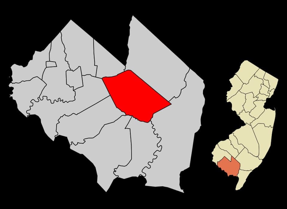
Millville, New Jersey, sits in a curious strategic pocket: close enough to major East Coast population centers to be relevant, but far enough into the rural pinelands to offer genuine buffer. Its location along the Maurice River and proximity to the Delaware Bay give it a resilience profile that many suburban or exurban towns lack, though it is by no means a fortress. For a relocator thinking in terms of civic unrest, supply chain disruptions, or natural disasters, Millville offers a mixed bag—real advantages in water access and low population density, offset by its position within a state with dense urban corridors and significant infrastructure targets.
Geographic position and natural advantages for long-term stability
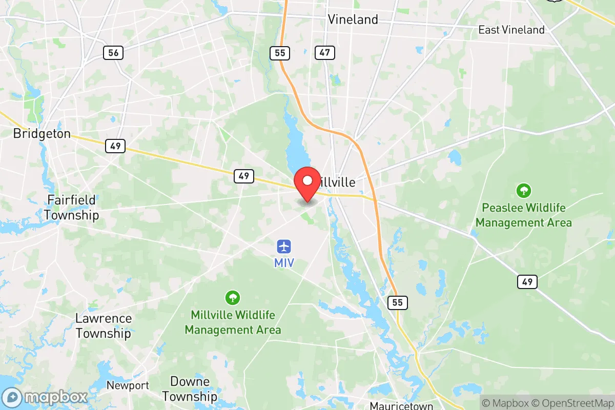
Millville’s geography is its strongest card. It sits in Cumberland County, part of the New Jersey Pine Barrens—a vast, sparsely populated region of sandy soil, pine forests, and wetlands that historically resisted development. The Pine Barrens act as a natural buffer: the terrain is difficult for large-scale movement, and the ecosystem supports a surprising amount of wildlife for the Northeast. The Maurice River runs through the town, providing a reliable surface water source, and the Delaware Bay is roughly 20 miles southwest, offering access to tidal waters and potential fishing grounds. The area’s elevation is low—typically 10 to 50 feet above sea level—but the sandy soil drains quickly, reducing flood risk compared to clay-heavy regions. Millville’s position also places it roughly 45 miles from Philadelphia and 90 miles from New York City, distances that are far enough to avoid immediate fallout from urban unrest but close enough to monitor events. For a prepper, the key advantage is advantage is the combination of water access, low population density (roughly 28,000 people in the city proper, with the county at about 150,000), and the natural barrier of the Pine Barrens. This is not a place that will be a primary target, but it is also not a place that can be easily isolated from regional chaos.
Risks, exposures, and proximity to fallout-relevant landmarks
The downsides are real and must be weighed. Millville lies within 100 miles of several high-value targets: the Philadelphia metropolitan area (population 6 million), the Delaware River refineries and chemical plants, and the Salem and Hope Creek nuclear power plants (about 30 miles north). A major event at any of these—whether a terrorist attack, industrial accident, or grid-down scenario—could produce fallout, refugees, or supply disruptions that reach Millville within hours. The town itself has a small airport (Millville Executive Airport) that could be a target for seizure or a vector for disease, and the nearby New Jersey Turnpike and Atlantic City Expressway provide fast routes for urban evacuees heading south. The biggest risk is the nuclear plants: a catastrophic release at Salem or Hope Creek would put Millville in the plume path depending on wind direction, and the area’s flat, sandy terrain offers little shielding from airborne contamination. Additionally, the Pine Barrens are fire-prone; dry summers can produce wildfires that spread quickly through the underbrush, and the region’s limited road network (mostly two-lane state highways) creates choke points for evacuation. For a relocator, the calculus is that Millville is not a primary target but sits within the secondary ring of risk—close enough to be affected by regional collapse, far enough to have a fighting chance if you have a plan.
Practical resilience for a relocator: food, water, energy, and defensibility
On the ground, Millville offers several practical advantages for a prepared individual or family. Water is the easiest win: the Maurice River is year-round and accessible from multiple points, and the shallow water table in the Pine Barrens means wells are viable in most areas. The sandy soil is poor for traditional farming but supports blueberries, cranberries, and some vegetables with amendment—Cumberland County is actually a top producer of blueberries in the state, so local knowledge exists. For energy, the area gets decent sun (about 200 sunny days per year, comparable to the Mid-Atlantic average), and solar panels are feasible on most residential lots. Wood is abundant in the surrounding forests, though burning pine creates creosote buildup, so a proper stove is necessary. Defensibility is moderate: Millville’s layout is a mix of older grid streets near the river and scattered suburban developments, with no natural high ground or chokepoints. The best defensive strategy is to choose a property on the outskirts, preferably with a buffer of woods or farmland, and to avoid the floodplain along the Maurice River. The local population is a mix of working-class families, retirees, and some agricultural workers—generally not a high-crime area, but the poverty rate (around 18%) means that in a prolonged crisis, resource competition could become a factor. The Millville Police Department is small (roughly 50 officers), and the Cumberland County Sheriff’s Office would be stretched thin in a regional emergency. For a relocator, the practical takeaway is that Millville is a decent base if you bring your own supplies, dig a well, and establish a network with like-minded neighbors—but it is not a self-sufficient homestead out of the box.
The overall strategic picture for Millville is one of cautious viability. It offers genuine natural advantages—water, forest buffer, low density—that many East Coast locations lack, and its distance from major cities provides a meaningful head start in a crisis. But it is not a remote redoubt; it sits within a state with high population density, significant infrastructure targets, and a political climate that may not favor individual preparedness. For a conservative-leaning relocator who values self-reliance and wants to be within a few hours of the Northeast corridor without being in the blast zone, Millville is worth a serious look. The key is to go in with eyes open: secure your water source, plan for nuclear plant contingencies, and build community before the crisis hits. In a world where the East Coast is increasingly fragile, Millville is a solid B-tier option—not a fortress, but a defensible position with room to maneuver.
* Values derived from national, state, county, city and local statistics and may differ in a specific area. Last updated: 2026-05-18T03:27:31.000Z
Narrative content on this page is AI-generated and may contain mistakes. Verify any details that matter before acting on them.
ReloMaps may earn a commission from affiliate links at no extra cost to you.