Photo: Wikipedia
Strategic Assessment of Pearl River County
Workable tactical position. Some exposure to population density or targets, but generally defensible in a crisis.
What does the Strategic Assessment tell us?
Our Strategic Assessment grades tactical survivability of an area. Major population centers, military targets, fallout zones, natural disasters, and border exposure all drive risk — lower exposure means a more defensible position in a crisis.
This is heavily inspired by Joel Skousen's Strategic Relocation book. Highly recommended you checkout the book ($)What does this tell us?
Our Strategic Assessment grades tactical survivability of an area. Major population centers, military targets, fallout zones, natural disasters, and border exposure all drive risk — lower exposure means a more defensible position in a crisis.
This is heavily inspired by Joel Skousen's Strategic Relocation book. Highly recommended you checkout the book ($)Strategic Pillars

Key Distances
Strategic Assessment Analysis
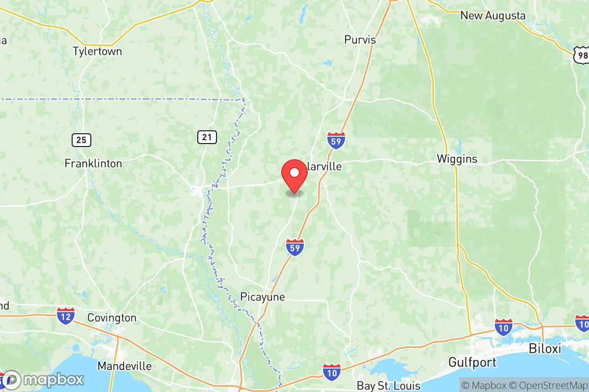
Pearl River County, Mississippi, offers a strategic balance of isolation and accessibility that appeals to those prioritizing resilience in an uncertain future. Located along the Louisiana border, roughly 45 miles northeast of New Orleans and 60 miles south of Hattiesburg, this county provides a buffer from major urban centers while still allowing access to critical infrastructure. Its position within the Pine Belt region, characterized by dense forests and low population density, makes it a viable option for relocators seeking to mitigate risks associated with civil unrest, mass casualty events, or large-scale disasters. The county seat, Poplarville, and the larger town of Picayune serve as practical hubs for supplies and community, but the surrounding rural areas offer the kind of space and separation that preppers and conservative-minded families often prioritize.
Geographic position and natural advantages for long-term security
Pearl River County sits within a region that benefits from both natural barriers and strategic distance from high-risk targets. The Pearl River itself forms the western boundary, providing a natural water source and a potential defensive line, while the vast DeSoto National Forest covers significant portions of the county, offering cover, resources, and limited road access that can deter unwanted movement. The county's elevation is modest—generally 50 to 200 feet above sea level—but it avoids the floodplain risks of coastal Mississippi, reducing exposure to hurricane storm surge. The proximity to the Gulf of Mexico, about 35 miles south, is a double-edged sword: it provides access to maritime resources but also places the county within the cone of tropical systems. However, the interior location means that most hurricanes weaken significantly before reaching Poplarville or the rural communities like Carriere and Nicholson. The county's position also places it outside the immediate blast radius of any major military installation or industrial complex, though it is within 100 miles of the Chevron Pascagoula Refinery and the Port of Gulfport, both potential targets in a conflict scenario. For a relocator, the key advantage is the ability to monitor threats from a distance while maintaining a low profile in a region that is not a primary strategic objective.
Risks, exposures, and proximity to fallout-relevant landmarks
No strategic assessment is complete without acknowledging the liabilities. Pearl River County is not immune to the risks that come with being in the American South. The most immediate natural threat is hurricane damage, with the 2005 Hurricane Katrina causing significant destruction in Picayune and surrounding areas, including widespread power outages and flooding. While the county is not coastal, storm surge can push up the Pearl River, and heavy rainfall can overwhelm local drainage. For those concerned with man-made disasters, the county's proximity to the Louisiana chemical corridor—often called "Cancer Alley"—is a concern. The Norco and Geismar refinery complexes, roughly 70 miles west, and the Stennis Space Center, just 20 miles south in Hancock County, represent potential targets for sabotage or accident. The Stennis facility, a NASA rocket engine test site, is a specific risk: a major incident there could release hazardous materials or draw military attention. Additionally, the county sits near Interstate 59, a major evacuation route from New Orleans, which could become a chokepoint during a crisis, attracting looting or refugee flows. The presence of the Poplarville Industrial Park and the Picayune Industrial Park means localized chemical storage, but these are small-scale compared to the Gulf Coast refineries. For a prepper, the key is to locate east of the Pearl River and away from major highways, using the forested areas as a buffer against both natural and man-made fallout.
Practical resilience for a relocator: food, water, energy, and defensibility
For a family or individual looking to establish a resilient homestead, Pearl River County offers several practical advantages. Water is abundant: the Pearl River and its tributaries, like the Hobolochitto Creek, provide surface water, and the county's aquifer is generally reliable for well drilling, though depth varies. The climate supports year-round gardening, with a growing season from March to November, and the sandy loam soil in areas like Carriere is suitable for root vegetables and fruit trees. Deer, turkey, and small game are plentiful in the national forest, providing a protein source for those with hunting skills. Energy resilience is achievable: the region gets ample sunlight for solar panels, and the lack of restrictive zoning in unincorporated areas allows for off-grid setups, including rainwater catchment and composting toilets. Defensibility is a mixed bag. The rural areas around Poplarville and the community of McNeill offer long sightlines and limited road access, but the county's overall population density of about 60 people per square mile means neighbors are present but not intrusive. The local law enforcement presence is limited—the Pearl River County Sheriff's Office has about 40 deputies for a 811-square-mile area—so self-reliance is a necessity. The county's political leanings are solidly conservative, with a strong Second Amendment culture and minimal local government interference, which aligns with the values of the target audience. However, the lack of a major hospital in the county (the nearest trauma center is in Hattiesburg) is a vulnerability for medical emergencies, and the local power grid is prone to outages during storms, making backup generation essential.
The overall strategic picture for Pearl River County is one of moderate resilience with clear trade-offs. It offers a defensible, resource-rich environment that is far enough from major targets to avoid immediate fallout, yet close enough to coastal infrastructure to be affected by regional disruptions. For a conservative-leaning relocator, the county's cultural alignment, low cost of land (averaging $3,000-$5,000 per acre in rural areas), and access to natural resources make it a viable long-term base. The risks—hurricanes, proximity to the Louisiana chemical corridor, and potential refugee flow from New Orleans—are manageable with proper planning, such as building to hurricane codes, storing supplies for 90 days, and establishing a network of like-minded neighbors. The county is not a fortress, but it is a practical choice for those who want to be prepared without going completely off-grid. The key is to choose a location away from the main roads and population centers, leveraging the forest and river as natural buffers, and to accept that no location in the lower 48 is entirely safe. Pearl River County, with its blend of isolation and accessibility, provides a solid foundation for a strategic relocation—provided you do the work to make it self-sufficient.
* Values derived from national, state, county, city and local statistics and may differ in a specific area. Last updated: 2026-05-11T22:32:41.000Z
Narrative content on this page is AI-generated and may contain mistakes. Verify any details that matter before acting on them.
ReloMaps may earn a commission from affiliate links at no extra cost to you.