Photo: Wikipedia
Strategic Assessment of Boone County
Workable tactical position. Some exposure to population density or targets, but generally defensible in a crisis.
What does the Strategic Assessment tell us?
Our Strategic Assessment grades tactical survivability of an area. Major population centers, military targets, fallout zones, natural disasters, and border exposure all drive risk — lower exposure means a more defensible position in a crisis.
This is heavily inspired by Joel Skousen's Strategic Relocation book. Highly recommended you checkout the book ($)What does this tell us?
Our Strategic Assessment grades tactical survivability of an area. Major population centers, military targets, fallout zones, natural disasters, and border exposure all drive risk — lower exposure means a more defensible position in a crisis.
This is heavily inspired by Joel Skousen's Strategic Relocation book. Highly recommended you checkout the book ($)Strategic Pillars

Key Distances
Strategic Assessment Analysis
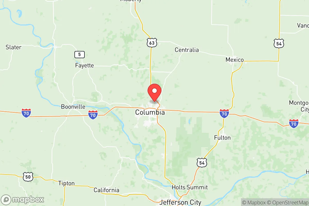
Boone County, Missouri, anchored by Columbia, offers a compelling mix of Midwestern stability and strategic depth for those prioritizing long-term resilience. Its location roughly 120 miles from both Kansas City and St. Louis places it outside the immediate blast and fallout zones of major metropolitan targets, while still providing access to their resources. The county's position along the I-70 corridor and near the Missouri River gives it logistical advantages for supply movement, yet its rolling hills and farmland provide natural buffers against the chaos that could engulf larger cities. For a conservative-leaning relocator focused on preparedness, Boone County represents a balanced bet: close enough to civilization to matter, far enough to survive its collapse.
Geographic position and natural advantages for long-term survival
Boone County sits in a sweet spot of the American heartland, far from coastal threats and major geopolitical chokepoints. The area is defined by the Missouri River cutting through its northern edge, providing a reliable water source and natural defensive terrain. The county's topography—a mix of wooded hills, limestone bluffs, and fertile river bottoms—offers multiple microclimates for agriculture and concealment. Unlike the flat, exposed plains to the west, Boone County's rolling landscape gives residents defensible positions and natural cover. The presence of the Mark Twain National Forest just to the south and numerous state parks like Finger Lakes State Park provide additional buffer zones and resources. The climate is temperate, with four distinct seasons that support diverse crops and livestock, though winters can be harsh enough to deter unprepared migrants. The soil quality in the Missouri River Valley is among the best in the state, making small-scale farming viable for those willing to work it.
Risks, exposures, and proximity to fallout-relevant landmarks
Boone County is not without its vulnerabilities, and a clear-eyed assessment must acknowledge them. The most significant risk is the county's proximity to the University of Missouri in Columbia, a major research institution with a nuclear research reactor. While the reactor is low-power and well-shielded, any catastrophic failure or targeted attack could create localized contamination. More broadly, Columbia's population of roughly 130,000 makes it a potential target for civil unrest or resource competition during a crisis. The I-70 corridor, which runs directly through the county, is a double-edged sword: it provides evacuation routes and supply lines, but also funnels refugees and looters from St. Louis and Kansas City. The nearby Callaway Nuclear Plant, about 30 miles east in Fulton, is a significant fallout concern. A meltdown or strike there could render large swaths of Boone County uninhabitable depending on wind patterns. Additionally, the county's position relative to Whiteman Air Force Base (home to B-2 stealth bombers) about 50 miles west means it sits in a potential secondary target zone. The Missouri River itself poses a flood risk, particularly in low-lying areas near Rocheport and Huntsdale, which could become impassable during spring thaws.
Practical resilience for a relocator: food, water, energy, and defensibility
For the individual or family looking to hunker down, Boone County offers solid fundamentals. Water is abundant: the Missouri River is the primary source, but numerous creeks, springs, and aquifers dot the county. The Boone County Regional Water Authority maintains infrastructure, but a prepper should have a private well or access to a reliable surface water source with filtration. The county's agricultural base is strong, with corn, soybeans, and hay dominating the landscape. Small-scale livestock operations are common, and the local farmers' markets in Columbia and Centralia provide a network for barter and trade. Energy resilience is mixed. The grid is reasonably stable, but rural areas are prone to outages during ice storms. Solar potential is moderate—Missouri gets about 200 sunny days per year—so a hybrid system with battery storage is advisable. Wood heat is a practical backup given the abundant timber. Defensibility varies by location. The rural towns of Harrisburg, Sturgeon, and Hallsville offer better security than Columbia's suburbs, with fewer entry points and more community cohesion. The county's law enforcement presence is adequate but would be overwhelmed in a widespread collapse. The best strategy is to join or form a neighborhood watch group, particularly in areas with natural chokepoints like the bluffs overlooking the Missouri River. The Boone County Sheriff's Office has a strong reputation, but self-reliance is the name of the game.
The overall strategic picture for Boone County is cautiously optimistic for the prepared relocator. It avoids the worst-case scenarios of coastal cities or major military hubs while still offering the infrastructure and community needed for a sustainable life. The key is to choose your specific location wisely: avoid the floodplains near the Missouri River, stay clear of the I-70 corridor's immediate vicinity, and establish yourself in a small town or rural homestead with good water and defensible terrain. The county's conservative lean—Boone County voted for Trump in 2024 by a narrow margin, but the rural precincts are solidly red—means a like-minded community exists, particularly in the outlying areas. The presence of the University of Missouri is a double-edged sword: it brings resources and talent, but also a progressive population that may not share your worldview. In a crisis, that cultural divide could become a practical one. For the single individual or family willing to put in the work—digging a well, stocking supplies, building relationships with neighbors—Boone County offers a viable long-term base. It's not a fortress, but it's a solid foundation in an uncertain world.
* Values derived from national, state, county, city and local statistics and may differ in a specific area. Last updated: 2026-06-01T04:47:28.000Z
Narrative content on this page is AI-generated and may contain mistakes. Verify any details that matter before acting on them.
ReloMaps may earn a commission from affiliate links at no extra cost to you.