
Photo: Wikipedia
Strategic Assessment of Mobridge, SD
Workable tactical position. Some exposure to population density or targets, but generally defensible in a crisis.
What does the Strategic Assessment tell us?
Our Strategic Assessment grades tactical survivability of an area. Major population centers, military targets, fallout zones, natural disasters, and border exposure all drive risk — lower exposure means a more defensible position in a crisis.
This is heavily inspired by Joel Skousen's Strategic Relocation book. Highly recommended you checkout the book ($)What does this tell us?
Our Strategic Assessment grades tactical survivability of an area. Major population centers, military targets, fallout zones, natural disasters, and border exposure all drive risk — lower exposure means a more defensible position in a crisis.
This is heavily inspired by Joel Skousen's Strategic Relocation book. Highly recommended you checkout the book ($)Strategic Pillars

Key Distances
Regional Safe Places
Below is our recommended "safe zones" in South Dakota and the surrounding area based on our strategic heuristics. For most people, it's unrealistic to live in a “safe zone” full-time due to work, family or other personal reasons. They tend to be more rural. However, many of these areas are perfect for second homes and retreat properties that double as a vacation home or even a short-term rental.


Important Note: For informational purposes only. This does not mean nothing bad ever happens in the green zones. Please use common sense. This is based on public data and modeled with AI. We tried to take a conservative approach but mistakes happen. We update this regularly as new information becomes available.
Solar Generator Recommendations
Backup power matters more here than in safer locations. We've picked three solar generators across budgets and capacity tiers — start with the budget unit if you only need a few essentials, or step up if you want to run a fridge and HVAC for days at a time.

Jackery Portable Power Station Explorer 300
Budget OptionPower on the Go: Weighing only 11 lbs, it's convenient to set up and store with book-sized foldable solar panels

BLUETTI Portable Power Station AC180
Designed for both indoor and outdoor scenarios, AC180 is highly capable as it has a robost capacity and continuous output power.

EF ECOFLOW DELTA Pro Ultra Power Station
Upgraded PickEcoFlow DELTA Pro Ultra is a whole-home energy system designed to grow with your family. Integrated with the Smart Home Panel 2, it scales to meet your evolving energy needs — keeping your home powered, intelligent, and secure through every stage of life.
We earn a commission, at no additional cost to you.
Strategic Assessment Analysis
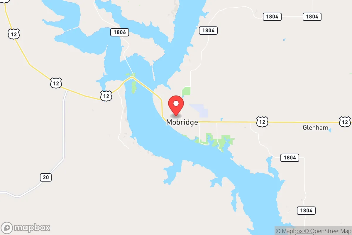
Mobridge, South Dakota, sits on the eastern bank of Lake Oahe along the Missouri River, and for a relocator with a prepper mindset, its strategic value comes down to one word: remoteness. This town of roughly 3,500 people is a solid 200 miles from the nearest major metro (Sioux Falls) and over 100 miles from the nearest interstate (I-94). That distance from population centers and critical infrastructure nodes gives it a baseline resilience that most of the country simply doesn't have. The Missouri River provides a reliable freshwater source, the surrounding prairie offers agricultural potential, and the low population density means you're not competing with millions for resources when things go sideways. It's not a fortress, but it's a damn good starting point for a long-term play.
Geographic position and natural advantages for long-term security
Mobridge's location is its primary asset. It's situated at the intersection of U.S. Highways 12 and 83, which are two-lane roads that can be easily monitored and controlled if needed. The Missouri River, specifically Lake Oahe, is a massive freshwater reservoir—over 230 miles long—that provides a near-limitless water supply for drinking, irrigation, and sanitation. The surrounding landscape is rolling prairie and farmland, which means you're not boxed in by mountains or forests; you have long sightlines and open fields that make approach detection easier. The climate is harsh—winters are brutal, with average January highs around 22°F and frequent blizzards—but that harshness is itself a defensive feature. It filters out the unprepared. The growing season is short (roughly 120 days), but the soil is fertile, and with a greenhouse and cold frames, you can produce a significant portion of your own food. The area is also far from any major fault lines, hurricane zones, or floodplains (the town sits on a bluff above the river), so natural disaster risk is low compared to coastal or seismic regions.
Risks, exposures, and proximity to fallout-relevant landmarks
No place is perfect, and Mobridge has its vulnerabilities. The most obvious is its proximity to the Standing Rock Indian Reservation, which borders the town to the south and west. While the reservation itself is not a direct threat, it does introduce a layer of jurisdictional complexity and potential for social friction during a crisis. More critically, Mobridge is about 150 miles from the Minot Air Force Base in North Dakota, which houses nuclear-capable B-52 bombers and is a high-priority target in any major conflict. A direct hit on Minot would likely produce fallout that could drift southeast toward Mobridge, depending on wind patterns. The same goes for the missile fields in western North Dakota—the Minuteman III silos are scattered across the plains, and a strike on those could create localized fallout zones. That said, Mobridge is far enough from Minot that you'd have time to shelter in place or relocate if the wind is unfavorable. The bigger concern is the rail line that runs through town—the BNSF mainline carries freight, including hazardous materials, and a derailment or sabotage event could disrupt supply chains or cause a localized chemical release. On the plus side, there are no major military bases, nuclear power plants, or large-scale industrial facilities within 100 miles, so the risk of a direct, targeted strike on Mobridge itself is essentially zero.
Practical resilience for a relocator: food, water, energy, and defensibility
For a relocator serious about self-sufficiency, Mobridge offers a workable baseline. Water is the easiest win: Lake Oahe is a massive, reliable source, and the town's municipal water system draws from it. In a grid-down scenario, a hand pump or a small solar-powered pump on a private well (the water table is high in the river valley) would keep you in clean water indefinitely. Food production is viable but requires effort. The growing season is short, but the soil is good for grains, root vegetables, and hardy greens. Local ranchers raise cattle and bison, and the Missouri River is a decent fishery (walleye, northern pike, catfish). Hunting is excellent—deer, pheasant, and waterfowl are abundant on the surrounding public lands (the Lake Oahe Wildlife Management Area is right there). Energy is a mixed bag. The area gets plenty of wind, so a small wind turbine paired with solar panels can provide off-grid power, but winter cloud cover and snow accumulation on panels are real issues. Wood is available but not abundant—you'd need to plan for a woodlot or rely on propane. Defensibility is decent but not fortress-level. The town itself is compact, with a few main roads in and out that can be watched. The surrounding terrain is open, so you'd see someone coming from miles away. A rural property with a good well, a garden, and a clear line of sight to the approach roads is the ideal setup. The nearest hospital is in Mobridge itself (a small critical access facility), but for serious trauma, you're looking at a 2-hour drive to Bismarck or Aberdeen—so medical self-sufficiency is a must.
The overall strategic picture for Mobridge is that it's a solid B+ location for a prepper or survivalist who wants to be far from the chaos but still within reach of essential services. It's not a bug-out location for a weekend—it's a long-term relocation play. The remoteness is both a blessing and a curse: you're safe from the immediate fallout of a major event, but you're also isolated from supply chains, medical care, and community support networks. The key is to arrive with your own infrastructure—solar, water filtration, seed stock, medical supplies, and a solid group of like-minded people. The local population is conservative, rural, and generally self-reliant, which means you're unlikely to face hostility from neighbors if you keep to yourself and contribute to the community. The biggest wildcard is the proximity to the Minot Air Force Base and the missile fields—if a nuclear exchange happens, Mobridge is in the secondary fallout zone, not the primary blast zone. That's a risk you can mitigate with a basement shelter and a good wind map. For someone looking to ride out the next decade of instability, Mobridge offers a defensible, resource-rich, and low-profile base of operations. It's not paradise, but it's a hell of a lot better than being in a suburb of a major city when the lights go out.
* Values derived from national, state, county, city and local statistics and may differ in a specific area. Last updated: 2026-04-23T12:56:36.000Z
Narrative content on this page is AI-generated and may contain mistakes. Verify any details that matter before acting on them.
ReloMaps may earn a commission from affiliate links at no extra cost to you.