Photo: Wikipedia
Strategic Assessment of Roosevelt County
Strong survivability profile. Good buffer from population centers, with manageable environmental and tactical risks.
What does the Strategic Assessment tell us?
Our Strategic Assessment grades tactical survivability of an area. Major population centers, military targets, fallout zones, natural disasters, and border exposure all drive risk — lower exposure means a more defensible position in a crisis.
This is heavily inspired by Joel Skousen's Strategic Relocation book. Highly recommended you checkout the book ($)What does this tell us?
Our Strategic Assessment grades tactical survivability of an area. Major population centers, military targets, fallout zones, natural disasters, and border exposure all drive risk — lower exposure means a more defensible position in a crisis.
This is heavily inspired by Joel Skousen's Strategic Relocation book. Highly recommended you checkout the book ($)Strategic Pillars

Key Distances
Strategic Assessment Analysis
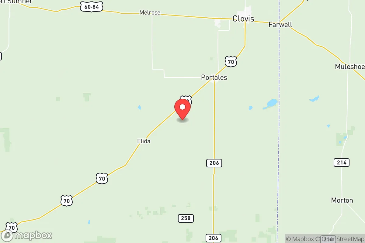
Roosevelt County, New Mexico, offers a strategic relocation option for those prioritizing resilience and distance from major population centers, anchored by the small city of Portales and the nearby town of Elida. Its location in the eastern plains provides a buffer from the coastal and urban corridors that are likely flashpoints during civil unrest or major disasters, while still maintaining access to essential supply routes via US Highway 70 and US Highway 60. The county’s low population density—roughly 18,000 residents spread over 2,500 square miles—means fewer targets for looting or resource competition, a key consideration for anyone planning for long-term stability. This is not a place for convenience; it’s a place for deliberate, prepared living.
Geographic position and natural advantages for long-term security
Roosevelt County sits in the High Plains, a flat, semi-arid region that offers clear sightlines and limited natural cover—a double-edged sword for defensibility but a clear advantage for monitoring approach routes. The county is roughly 100 miles from the Texas border and 200 miles from the major population hub of Lubbock, Texas, which itself is a secondary risk zone. The nearest military installation of note is Cannon Air Force Base, about 60 miles west in Clovis, which provides a potential security buffer but also a target in a major conflict scenario. The area’s primary natural advantage is its groundwater: the Ogallala Aquifer lies beneath much of the county, providing a reliable water source for wells, a critical asset when municipal systems fail. The terrain is mostly agricultural—cotton, peanuts, and dairy operations dominate—meaning local food production is a reality, not a hypothetical. The lack of dense forest or mountainous terrain reduces wildfire risk, though the open plains make wind a constant factor, which can complicate both travel and structure defense.
Risks, exposures, and proximity to fallout-relevant landmarks
The primary risk in Roosevelt County is its proximity to the U.S. nuclear weapons complex and potential fallout corridors. The county lies roughly 120 miles southeast of the Pantex Plant near Amarillo, Texas, the nation’s primary nuclear weapon assembly and disassembly facility. In a major conflict, Pantex is a high-value target, and prevailing winds from the northwest could carry fallout across the Texas Panhandle into eastern New Mexico. Additionally, the county is about 150 miles from the Waste Isolation Pilot Plant (WIPP) near Carlsbad, New Mexico, a deep geological repository for transuranic waste—another potential contamination source if compromised. On the positive side, Roosevelt County is far from the major refinery corridors of Houston and the Gulf Coast, which are prime targets for both conventional and cyber attacks. The county has no major dams, chemical plants, or nuclear power plants within its borders, reducing local industrial risk. The biggest day-to-day threat is severe weather: tornadoes are possible in spring and summer, and blizzards can shut down roads in winter. The flat terrain also means flash flooding during heavy rains, though this is less common than in mountainous areas.
Practical resilience for a relocator: food, water, energy, and defensibility
For a relocator focused on self-sufficiency, Roosevelt County offers a strong foundation. Water is the most critical resource, and the Ogallala Aquifer provides a deep, reliable source for private wells—though drilling depths of 200 to 400 feet are common, and well installation costs can run $10,000 to $20,000. Municipal water in Portales and Elida is treated but sourced from the same aquifer, so a backup well is a wise investment. Food resilience is bolstered by local agriculture: the county is a top producer of peanuts in New Mexico, and dairy farms supply milk and cheese. Hunting is viable for mule deer and pronghorn antelope, with public land access through the Bureau of Land Management (BLM) holdings scattered across the county. Energy is a mixed bag: the grid is served by Xcel Energy, which relies on a mix of coal, natural gas, and wind. Power outages during storms are common, so solar panels with battery storage are a practical addition. The county’s low population density means defensibility is manageable—rural properties with clear sightlines and limited access points are the norm. However, the open terrain means a determined group could approach from any direction, so perimeter security (fencing, motion sensors, and a good dog) is more important than natural barriers. The nearest major medical facility is Roosevelt General Hospital in Portales, a critical access hospital with limited trauma capabilities; for serious injuries, evacuation to Lubbock or Amarillo is necessary, a 2-3 hour drive under normal conditions.
The overall strategic picture for Roosevelt County is one of trade-offs. It offers genuine advantages for those seeking distance from urban collapse, nuclear targets, and industrial fallout zones, with reliable water and local food production as core assets. The risks are real but manageable: proximity to Pantex and WIPP requires a fallout plan (a basement or interior shelter with sealed ventilation), and the harsh climate demands robust infrastructure. For a conservative-leaning relocator who values self-reliance, community ties, and a slower pace, this area is a solid bet—provided you come prepared with the skills and resources to handle the isolation. It’s not a bug-out location for a weekend; it’s a long-term homesteading play in a region that rewards patience and planning.
* Values derived from national, state, county, city and local statistics and may differ in a specific area. Last updated: 2026-05-28T02:24:19.000Z
Narrative content on this page is AI-generated and may contain mistakes. Verify any details that matter before acting on them.
ReloMaps may earn a commission from affiliate links at no extra cost to you.