Photo: Wikipedia
Strategic Assessment of Nogales, AZ
Meaningful friction. Expect exposure to either population pressure, blast zones, or natural disaster risk. Consider buying a retreat property.
What does the Strategic Assessment tell us?
Our Strategic Assessment grades tactical survivability of an area. Major population centers, military targets, fallout zones, natural disasters, and border exposure all drive risk — lower exposure means a more defensible position in a crisis.
This is heavily inspired by Joel Skousen's Strategic Relocation book. Highly recommended you checkout the book ($)What does this tell us?
Our Strategic Assessment grades tactical survivability of an area. Major population centers, military targets, fallout zones, natural disasters, and border exposure all drive risk — lower exposure means a more defensible position in a crisis.
This is heavily inspired by Joel Skousen's Strategic Relocation book. Highly recommended you checkout the book ($)Strategic Pillars

Key Distances
Regional Safe Places
Below is our recommended "safe zones" in Arizona and the surrounding area based on our strategic heuristics. For most people, it's unrealistic to live in a “safe zone” full-time due to work, family or other personal reasons. They tend to be more rural. However, many of these areas are perfect for second homes and retreat properties that double as a vacation home or even a short-term rental.
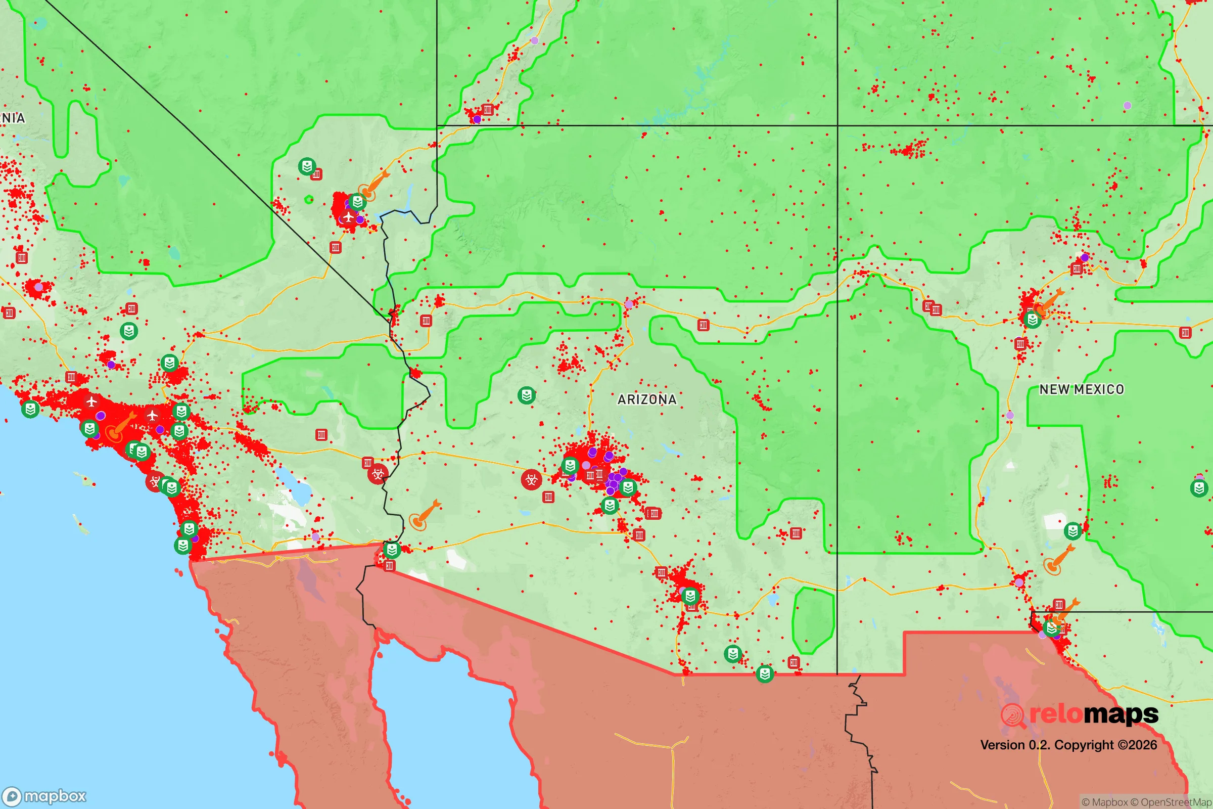
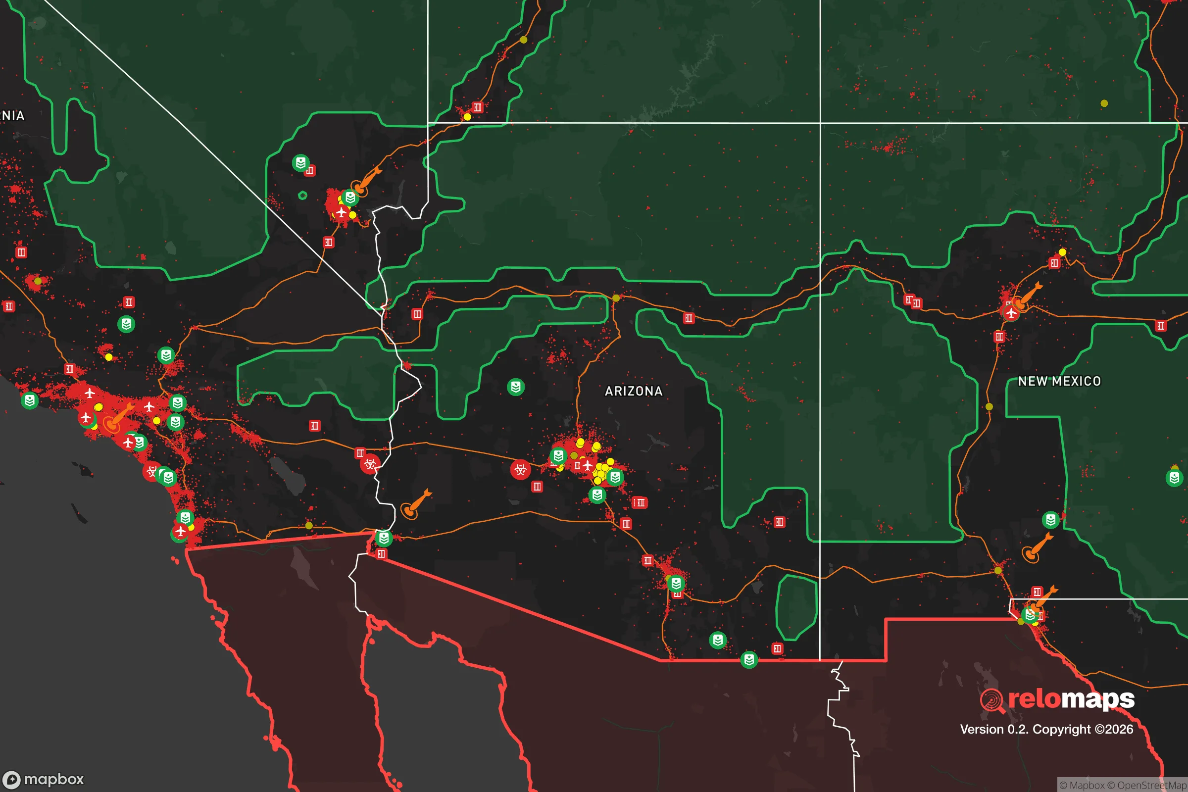
Important Note: For informational purposes only. This does not mean nothing bad ever happens in the green zones. Please use common sense. This is based on public data and modeled with AI. We tried to take a conservative approach but mistakes happen. We update this regularly as new information becomes available.
Solar Generator Recommendations
Backup power matters more here than in safer locations. We've picked three solar generators across budgets and capacity tiers — start with the budget unit if you only need a few essentials, or step up if you want to run a fridge and HVAC for days at a time.

Jackery Portable Power Station Explorer 300
Budget OptionPower on the Go: Weighing only 11 lbs, it's convenient to set up and store with book-sized foldable solar panels

BLUETTI Portable Power Station AC180
Designed for both indoor and outdoor scenarios, AC180 is highly capable as it has a robost capacity and continuous output power.

EF ECOFLOW DELTA Pro Ultra Power Station
Upgraded PickEcoFlow DELTA Pro Ultra is a whole-home energy system designed to grow with your family. Integrated with the Smart Home Panel 2, it scales to meet your evolving energy needs — keeping your home powered, intelligent, and secure through every stage of life.
We earn a commission, at no additional cost to you.
Strategic Assessment Analysis
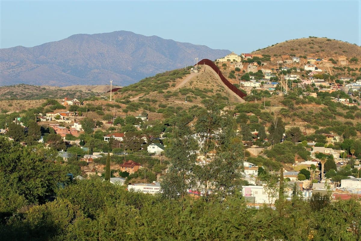
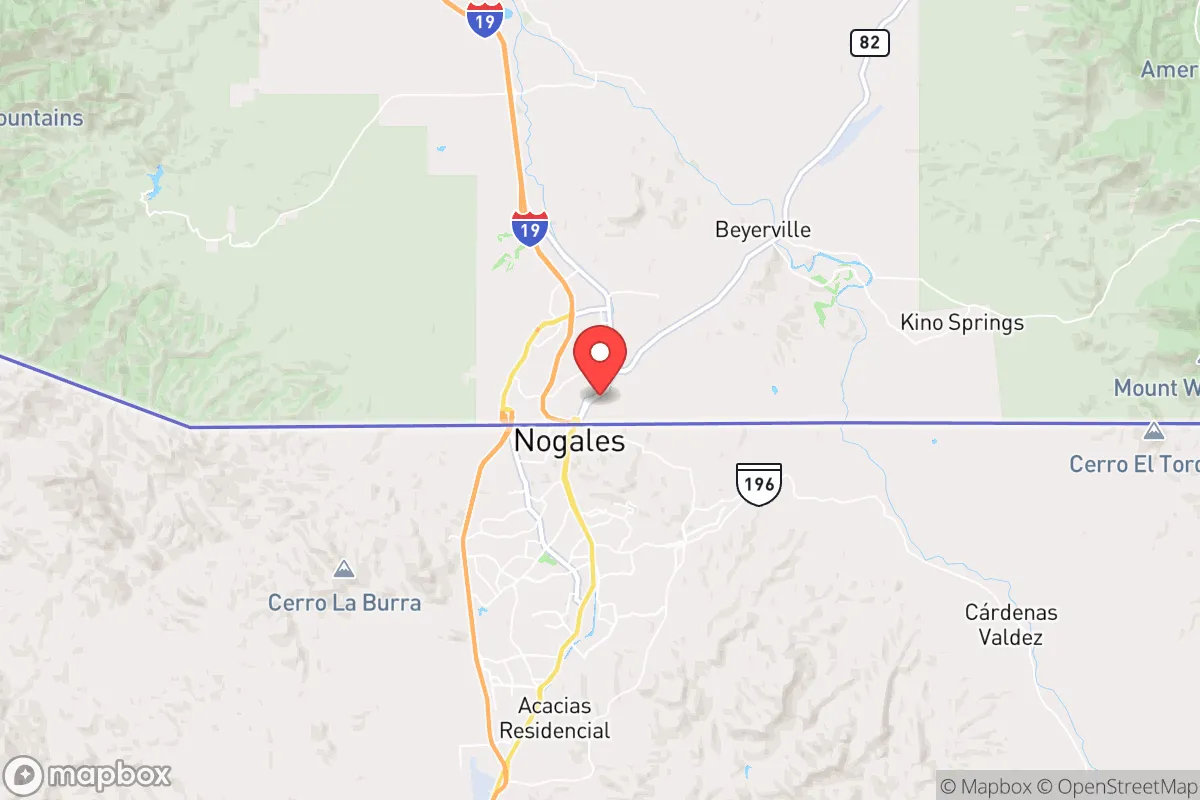
Nogales, Arizona, sits directly on the U.S.-Mexico border, a position that is both its greatest strategic asset and its most significant liability for a relocator with a prepper mindset. The town’s resilience is built on its isolation from major population centers—Tucson is 60 miles north, Phoenix 180 miles—and its access to a binational supply chain that could prove critical during a national-level disruption. However, that same border location introduces unique exposure to cartel activity, illegal cross-border traffic, and potential fallout from a cascading crisis in Mexico. For a conservative-leaning individual or family seeking a defensible, low-profile location with a strong sense of self-reliance, Nogales offers a mixed but potentially viable strategic picture.
Geographic isolation and the natural buffer of the border
Nogales sits in the Sonoran Desert at roughly 3,800 feet elevation, giving it a climate that is hot in summer but cooler than Phoenix, with winter lows that rarely freeze hard. The surrounding terrain is rugged, with the Patagonia Mountains to the east and the Tumacacori Mountains to the west, creating natural chokepoints and limited road access. The only major highway is I-19, which runs north to Tucson—a single paved artery that could be monitored or blocked if needed. The border fence itself, a mix of steel bollards and vehicle barriers, runs through the center of town, but it is porous in practice, with hundreds of undocumented crossings daily. For a prepper, this means the area offers natural defensibility via terrain, but the border is not a hard security line—it’s a sieve. The nearby Coronado National Forest provides thousands of acres of public land for hunting, foraging, and off-grid retreat, though water is scarce and fire risk is high in dry years.
Risks from cartel activity, border instability, and proximity to potential fallout zones
The most immediate risk in Nogales is the spillover from organized crime in Sonora, Mexico. The Sinaloa Cartel and the Cártel de Sonora both operate in the region, and while Nogales, Arizona, is not a warzone, it experiences regular drug seizures, vehicle thefts, and occasional armed confrontations near the port of entry. In a scenario of U.S. civil unrest or a collapse of Mexican state authority, Nogales could become a flashpoint for mass migration, cartel violence, or even a temporary closure of the border, cutting off the town from its Mexican sister city. The Nogales port of entry is one of the busiest land crossings in the U.S., handling over 20,000 vehicles and 5,000 pedestrians daily—a concentration of human traffic that could become a vector for disease, smuggling, or targeted attacks. Fallout-wise, Nogales is far from any major nuclear power plant (the nearest is Palo Verde near Phoenix, 180 miles north) and is not near any known strategic military targets. However, the nearby Davis-Monthan Air Force Base in Tucson (60 miles north) is a potential target in a major conflict, and the I-19 corridor would likely be a primary evacuation route, creating congestion and risk. The town’s proximity to the border also means it could be a staging area for federal law enforcement or military operations during a national emergency, which could bring unwanted attention.
Practical resilience: food, water, energy, and defensibility for a relocator
Water is the critical vulnerability in Nogales. The Santa Cruz River runs through the area but is mostly dry; the town relies on groundwater from the Nogales Aquifer, which is shared with Mexico and is under increasing stress from overuse and contamination. The Nogales International Wastewater Treatment Plant treats sewage from both sides of the border, but it has a history of spills and capacity issues. A relocator would need to invest in rainwater harvesting (annual rainfall is about 15 inches) and possibly a well, though drilling deep is expensive and permits are required. Food security is more promising: the Santa Cruz Valley has a long agricultural history, and local farms produce pecans, apples, and livestock. The Nogales Produce Terminal is a major hub for imported produce from Mexico, meaning fresh fruits and vegetables are abundant in normal times, but this supply chain could be disrupted by a border closure. For long-term food storage, the dry climate is favorable for dehydration and root cellaring. Energy is relatively stable: the local grid is served by UniSource Energy Services, but outages from monsoon storms or equipment failure are common. Solar is viable—the area averages 300+ sunny days per year—and off-grid solar with battery storage is a practical investment. Defensibility is mixed: the town itself is compact (population ~20,000) with a grid layout, but the surrounding hills offer good vantage points for a rural retreat. The local sheriff’s office and Nogales Police Department are understaffed, and response times in the outskirts can be 20-30 minutes. A relocator should plan for a rural property north or east of town, away from the border fence, with a clear line of sight to approach routes. The local gun culture is strong, and Arizona has constitutional carry, so firearms ownership is straightforward.
The overall strategic picture for Nogales is one of calculated trade-offs. It offers genuine isolation from the chaos of major cities, a climate that supports off-grid living, and a community that is accustomed to self-reliance and border realities. But the risks from cartel activity, water scarcity, and the potential for border-related crises are real and cannot be ignored. For a conservative prepper who values low visibility, a strong local network, and the ability to live with minimal government interference, Nogales is a viable option—provided they secure a reliable water source, establish a defensible rural property, and maintain a low profile. It is not a sanctuary; it is a frontier outpost that demands constant awareness and preparation. If you can handle the heat, the dust, and the occasional gunfire from across the fence, it might be the right fit. If you want a quiet, low-risk retreat, look further north.
* Values derived from national, state, county, city and local statistics and may differ in a specific area. Last updated: 2026-04-19T11:55:17.000Z
Narrative content on this page is AI-generated and may contain mistakes. Verify any details that matter before acting on them.
ReloMaps may earn a commission from affiliate links at no extra cost to you.