
Photo: Wikipedia
Strategic Assessment of Pierce County
Deep buffer from population centers and strategic targets. Low natural disaster risk and minimal exposure to border or coastal threats.
What does the Strategic Assessment tell us?
Our Strategic Assessment grades tactical survivability of an area. Major population centers, military targets, fallout zones, natural disasters, and border exposure all drive risk — lower exposure means a more defensible position in a crisis.
This is heavily inspired by Joel Skousen's Strategic Relocation book. Highly recommended you checkout the book ($)What does this tell us?
Our Strategic Assessment grades tactical survivability of an area. Major population centers, military targets, fallout zones, natural disasters, and border exposure all drive risk — lower exposure means a more defensible position in a crisis.
This is heavily inspired by Joel Skousen's Strategic Relocation book. Highly recommended you checkout the book ($)Strategic Pillars

Key Distances
Strategic Assessment Analysis
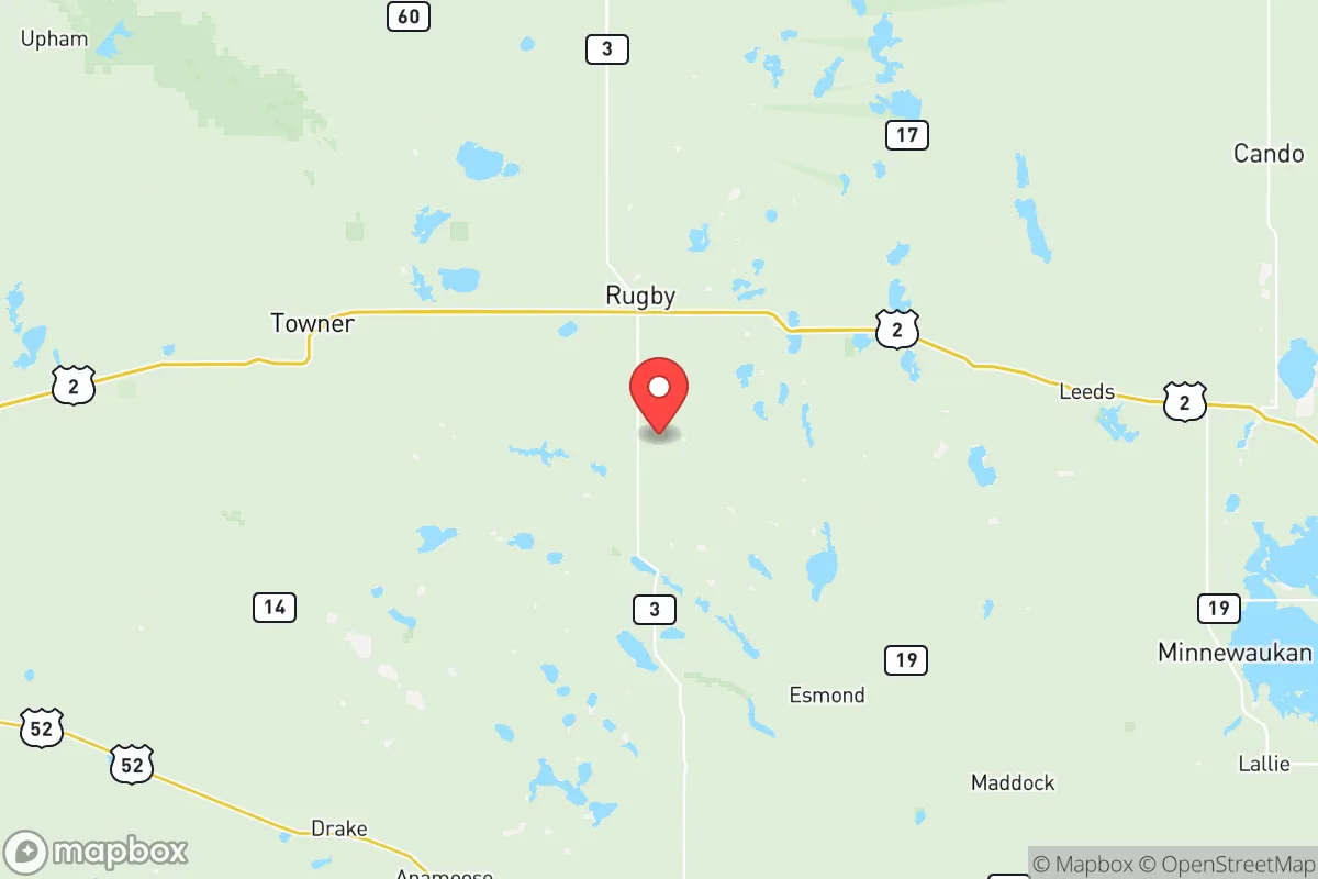
Pierce County, North Dakota, sits in a sweet spot for those serious about long-term resilience: far enough from major population centers to avoid the worst of civic unrest or fallout, yet close enough to regional infrastructure to make supply runs practical. The county seat, Rugby, is famously the geographical center of North America, but more importantly, it anchors a region where the nearest metro areas—Minot (about 50 miles west) and Bismarck (about 120 miles south)—are small enough to be manageable in a crisis, not sprawling targets. For a relocator weighing strategic depth against isolation, Pierce County offers a rare combination of agricultural self-sufficiency, low population density, and a climate that naturally discourages mass migration.
Geographic position and natural advantages for long-term security
Pierce County’s location in north-central North Dakota gives it a defensive buffer that’s hard to beat. The county is roughly 1,000 square miles of rolling prairie and farmland, with a population under 4,000—meaning you’re looking at about four people per square mile. That’s a density that makes social collapse scenarios far less likely to reach your doorstep. The Souris River runs through the eastern part of the county, providing a reliable water source, and the area sits atop the Dakota Aquifer, which means well water is accessible for those who drill deep enough. Rugby itself is a functional small town with a hospital, a grocery store, and a grain elevator—critical for barter and supply in a grid-down situation. The county’s position also puts it within a day’s drive of the Canadian border (about 90 miles north), which could be a strategic fallback if things go sideways in the lower 48. For a conservative-leaning relocator, this is the kind of place where you can quietly build a life without drawing attention, while still having access to Minot Air Force Base (home to nuclear-capable B-52s) for potential security cooperation if the situation demands it.
Risks, exposures, and proximity to fallout-relevant landmarks
No place is perfect, and Pierce County has its own set of risks that a strategic relocator needs to account for. The most obvious is the harsh winter climate: temperatures can drop to -40°F with wind chills, and blizzards can cut off roads for days. That’s a resilience challenge that requires serious preparation—think wood stoves, backup generators, and a vehicle capable of deep snow. On the man-made risk side, the county is about 50 miles from Minot Air Force Base, which is a high-value target in any major conflict. If a nuclear exchange happens, the base’s missile fields and bomber fleet make it a primary strike location. Fallout patterns depend on wind, but prevailing westerlies mean Pierce County could see some contamination if Minot is hit. That said, the county is far enough from the base that a well-stocked basement or storm shelter would provide adequate protection for the first 72 hours. Other nearby landmarks include the oil fields of the Bakken formation (about 100 miles west), which could become a zone of resource conflict during energy disruptions, and the Canadian border crossings at Portal and Northgate, which could see refugee flows in a collapse scenario. The key takeaway: Pierce County is not a zero-risk zone, but its risks are manageable with proper planning, unlike the existential threats of living near a major port, refinery, or megacity.
Practical resilience for a relocator: food, water, energy, and defensibility
For someone serious about self-sufficiency, Pierce County delivers on the basics. The soil is fertile for small-scale farming—wheat, barley, canola, and sunflowers are the cash crops, but you can easily pivot to potatoes, root vegetables, and hardy greens for personal food security. The growing season is short (about 120 days), so a greenhouse or cold frame is essential for extending it. Water is the real strength here: the Souris River and numerous small lakes (like Lake Upsilon and Lake George) provide surface water, and the aquifer means wells are viable. Most rural properties already have a well, but you’ll want to test for hardness and possibly install a hand pump for grid-down scenarios. Energy is straightforward: wind is abundant, and solar works well in the summer months, but winter days are short and cloudy, so a propane or diesel generator with a large fuel cache is a must. Wood is available from the Turtle Mountains (about 30 miles north), but it’s not a forested region, so plan for coal or propane as primary heating backups. Defensibility is excellent: the flat terrain means long sightlines, and the low population density means you can secure a perimeter without neighbors interfering. Rural properties often have outbuildings that can be fortified, and the local sheriff’s department is responsive but not overbearing—a plus for those who value privacy and the right to keep and bear arms. For a single individual or a family, this is a place where you can realistically achieve 80% self-sufficiency within two years, assuming you arrive with capital and a plan.
The overall strategic picture for Pierce County is one of calculated trade-offs. It’s not a prepper’s paradise—the winters are brutal, the nearest major medical center is in Minot, and the risk from Minot Air Force Base is real but manageable with a fallout shelter and a good weather radio. What it offers is a low-profile, low-density environment where a conservative-minded relocator can build a resilient lifestyle without the constant threat of urban unrest, supply chain collapse, or mass casualty events that plague the coasts. The county’s agricultural base, water access, and distance from major targets make it a solid B+ choice for those who value long-term stability over convenience. If you’re willing to invest in winter preparedness and a solid retreat plan, Pierce County is a place where you can ride out the storm—literally and figuratively—while still being part of a functional community that shares your values.
* Values derived from national, state, county, city and local statistics and may differ in a specific area. Last updated: 2026-05-12T18:03:09.000Z
Narrative content on this page is AI-generated and may contain mistakes. Verify any details that matter before acting on them.
ReloMaps may earn a commission from affiliate links at no extra cost to you.