Photo: Wikipedia
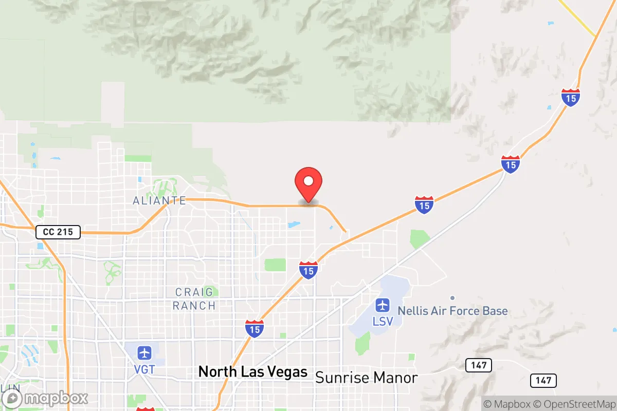
Strategic Assessment of North Las Vegas, NV
Multiple tactical vulnerabilities. Population density, target proximity, or disaster risk are likely compounding. A retreat property and exit planning is required.
What does the Strategic Assessment tell us?
Our Strategic Assessment grades tactical survivability of an area. Major population centers, military targets, fallout zones, natural disasters, and border exposure all drive risk — lower exposure means a more defensible position in a crisis.
This is heavily inspired by Joel Skousen's Strategic Relocation book. Highly recommended you checkout the book ($)What does this tell us?
Our Strategic Assessment grades tactical survivability of an area. Major population centers, military targets, fallout zones, natural disasters, and border exposure all drive risk — lower exposure means a more defensible position in a crisis.
This is heavily inspired by Joel Skousen's Strategic Relocation book. Highly recommended you checkout the book ($)Strategic Pillars

Key Distances
Regional Safe Places
Below is our recommended "safe zones" in Nevada and the surrounding area based on our strategic heuristics. For most people, it's unrealistic to live in a “safe zone” full-time due to work, family or other personal reasons. They tend to be more rural. However, many of these areas are perfect for second homes and retreat properties that double as a vacation home or even a short-term rental.
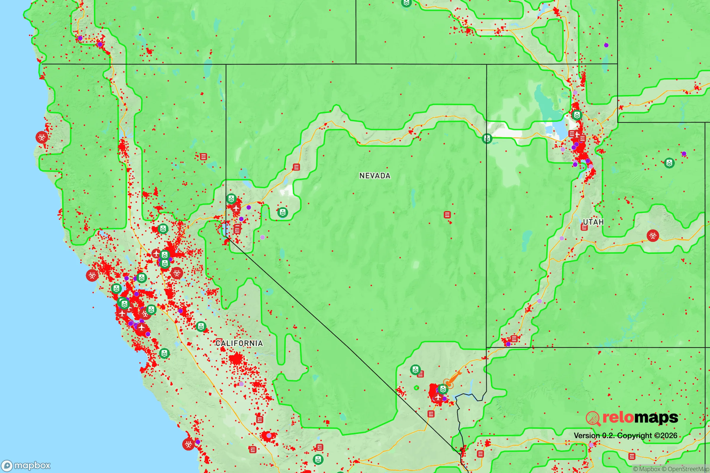
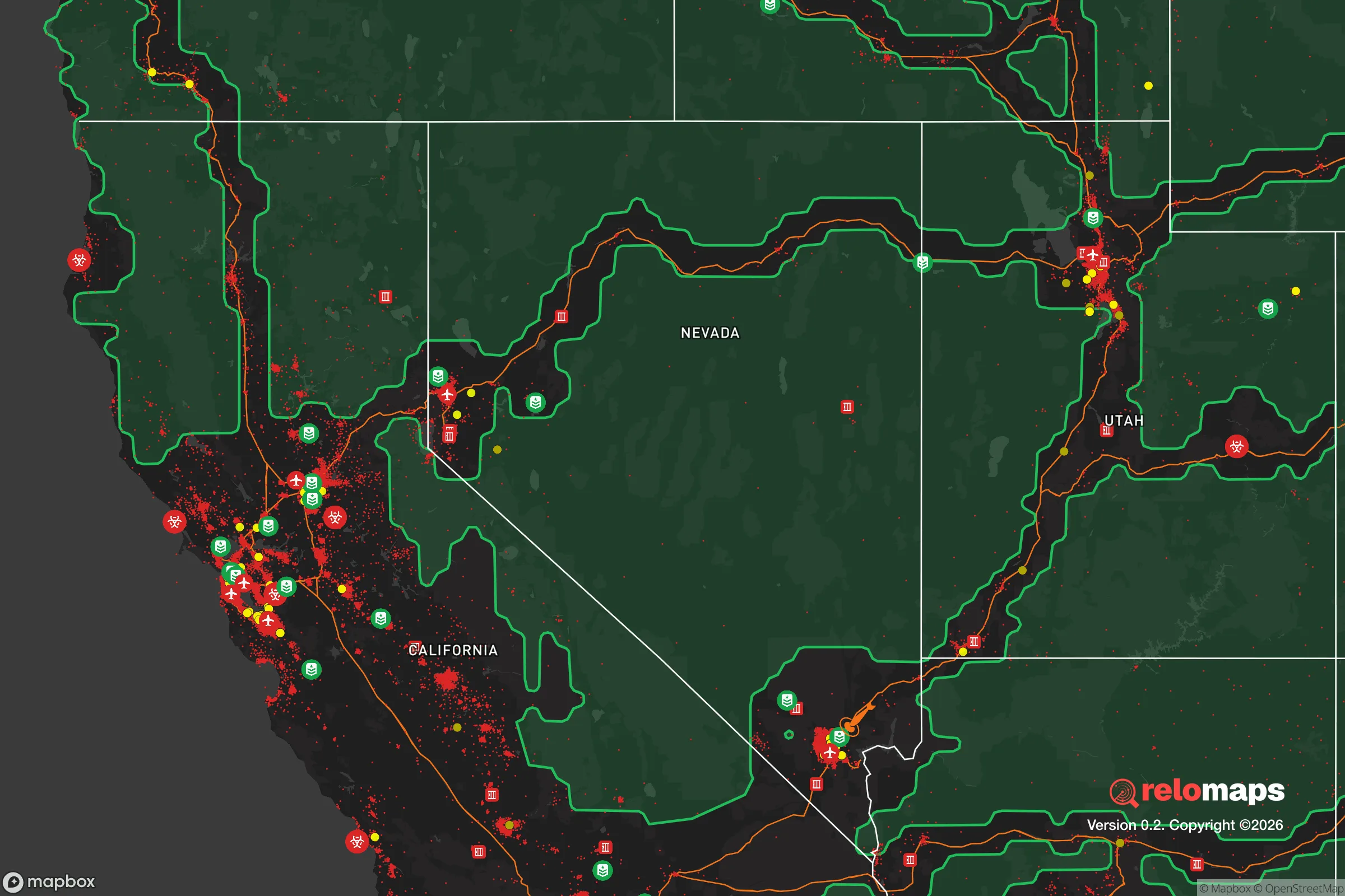
Important Note: For informational purposes only. This does not mean nothing bad ever happens in the green zones. Please use common sense. This is based on public data and modeled with AI. We tried to take a conservative approach but mistakes happen. We update this regularly as new information becomes available.
Solar Generator Recommendations
Backup power matters more here than in safer locations. We've picked three solar generators across budgets and capacity tiers — start with the budget unit if you only need a few essentials, or step up if you want to run a fridge and HVAC for days at a time.

Jackery Portable Power Station Explorer 300
Budget OptionPower on the Go: Weighing only 11 lbs, it's convenient to set up and store with book-sized foldable solar panels

BLUETTI Portable Power Station AC180
Designed for both indoor and outdoor scenarios, AC180 is highly capable as it has a robost capacity and continuous output power.

EF ECOFLOW DELTA Pro Ultra Power Station
Upgraded PickEcoFlow DELTA Pro Ultra is a whole-home energy system designed to grow with your family. Integrated with the Smart Home Panel 2, it scales to meet your evolving energy needs — keeping your home powered, intelligent, and secure through every stage of life.
We earn a commission, at no additional cost to you.
Strategic Assessment Analysis
North Las Vegas presents a complex strategic picture for the conservative prepper. Its location in the Mojave Desert offers natural isolation and a low-humidity environment that preserves supplies, but its proximity to the Las Vegas Strip—a high-value target for both terrorism and civil unrest—introduces significant risk. The city’s resilience hinges on its ability to function as a secondary node in a region dominated by a single economic engine, which is both a strength and a vulnerability. For the relocator prioritizing self-sufficiency and security, North Las Vegas demands a clear-eyed assessment of its geographic assets and its exposure to cascading failures from the nearby metropolitan core.
Geographic position and natural advantages for long-term survival
North Las Vegas sits at roughly 2,200 feet elevation in the Mojave Desert, a landscape that provides natural barriers to large-scale movement. The surrounding mountains—the Sheep Range to the north and the Spring Mountains to the west—create chokepoints that could be defended or monitored in a grid-down scenario. The dry climate means corrosion and mold are minimal, extending the shelf life of stored food, ammunition, and medical supplies. Water is the obvious Achilles' heel: the city relies entirely on the Colorado River via Lake Mead, which is currently at about 30% capacity and subject to ongoing interstate allocation disputes. However, the region's low annual rainfall (roughly 4 inches) means flash flooding is rare, and the hard-packed desert soil makes for stable construction. The area's position along Interstate 15 gives access to both the California markets and the interior West, but in a crisis, that same highway becomes a liability—a funnel for refugees from Las Vegas proper. For the prepper, the natural advantages are real but conditional on securing a reliable water source, such as a deep well or rainwater catchment system, which is feasible on larger parcels in the northern outskirts.
Risks, exposures, and proximity to fallout-relevant landmarks
The single greatest strategic liability of North Las Vegas is its proximity to the Las Vegas Strip, roughly 10 miles south. The Strip is a global symbol of American excess and a high-probability target for coordinated attacks, whether from foreign adversaries, domestic terror cells, or cyber-enabled infrastructure sabotage. A mass casualty event on the Strip—say, a vehicle-borne IED or a coordinated shooting—would overwhelm the region's medical infrastructure, which is already strained. The University Medical Center trauma center in Las Vegas is the only Level I facility in the region, and North Las Vegas has no equivalent. Additionally, Nellis Air Force Base lies directly east of the city, a major military installation that could become a target for standoff attacks or a focal point for martial law operations. The nearby Hoover Dam, a critical piece of national infrastructure, is a plausible target for sabotage that would cripple power and water delivery to the entire valley. In a civil unrest scenario, the city's demographics—roughly 60% Hispanic and 30% White, with a median household income around $55,000—could lead to resource competition and factional tensions. The risk profile is clear: North Las Vegas is not a retreat; it is a buffer zone that will see the first wave of fallout from any major event in Las Vegas proper.
Practical resilience for a relocator: food, water, energy, and defensibility
For the individual or family serious about self-sufficiency, North Las Vegas offers a mixed bag. Water storage is non-negotiable; the municipal supply is treated Colorado River water, and a prolonged power outage would shut down the pumps. A 1,000-gallon cistern paired with a Berkey filter system is the baseline. The desert climate allows for solar energy generation year-round, with over 300 sunny days annually, making photovoltaic panels a reliable investment. Battery storage is essential, as grid outages are common during summer heat waves. Food production is limited by the arid conditions, but raised-bed gardening with drip irrigation and shade cloth can yield tomatoes, peppers, squash, and herbs from March through October. The city's zoning allows for backyard chickens, and some areas permit goats with a permit. Defensibility is a challenge: most homes sit on flat lots with chain-link fences, offering little concealment. The northern neighborhoods near the Sheep Range—areas like Aliante or the rural tracts off US-93—provide more space and fewer neighbors. Community is a double-edged sword; the area has a growing population of like-minded preppers and veterans, but also a transient population tied to the service industry. Building a trusted network of three to five families before a crisis is critical. For energy resilience, a propane generator with a 500-gallon tank is a practical backup, as propane is widely available and stores indefinitely.
The overall strategic picture for North Las Vegas is one of calculated risk. It offers genuine advantages in climate, solar potential, and relative isolation from coastal population centers, but it is not a standalone survival location. The city's fate is tied to Las Vegas, and any major event—whether a terrorist attack, a water crisis, or civil unrest—will ripple northward. For the conservative relocator who wants to stay within driving distance of work in the valley but maintain a prepared household, North Las Vegas can work, provided you invest in water independence, solar power, and a defensible perimeter. The key is to treat the city as a staging ground, not a sanctuary. If you're looking for a place to ride out a national-level disruption without being in the direct blast zone, North Las Vegas demands constant vigilance and a robust plan for self-reliance. It is not for the casual prepper, but for the disciplined strategist, it offers a viable foothold in the desert.
* Values derived from national, state, county, city and local statistics and may differ in a specific area. Last updated: 2026-04-23T04:09:41.000Z
Narrative content on this page is AI-generated and may contain mistakes. Verify any details that matter before acting on them.
ReloMaps may earn a commission from affiliate links at no extra cost to you.