Photo: Wikipedia
Strategic Assessment of Oceanside, CA
Multiple tactical vulnerabilities. Population density, target proximity, or disaster risk are likely compounding. A retreat property and exit planning is required.
What does the Strategic Assessment tell us?
Our Strategic Assessment grades tactical survivability of an area. Major population centers, military targets, fallout zones, natural disasters, and border exposure all drive risk — lower exposure means a more defensible position in a crisis.
This is heavily inspired by Joel Skousen's Strategic Relocation book. Highly recommended you checkout the book ($)What does this tell us?
Our Strategic Assessment grades tactical survivability of an area. Major population centers, military targets, fallout zones, natural disasters, and border exposure all drive risk — lower exposure means a more defensible position in a crisis.
This is heavily inspired by Joel Skousen's Strategic Relocation book. Highly recommended you checkout the book ($)Strategic Pillars

Key Distances
Regional Safe Places
Below is our recommended "safe zones" in California and the surrounding area based on our strategic heuristics. For most people, it's unrealistic to live in a “safe zone” full-time due to work, family or other personal reasons. They tend to be more rural. However, many of these areas are perfect for second homes and retreat properties that double as a vacation home or even a short-term rental.


Important Note: For informational purposes only. This does not mean nothing bad ever happens in the green zones. Please use common sense. This is based on public data and modeled with AI. We tried to take a conservative approach but mistakes happen. We update this regularly as new information becomes available.
Solar Generator Recommendations
Backup power matters more here than in safer locations. We've picked three solar generators across budgets and capacity tiers — start with the budget unit if you only need a few essentials, or step up if you want to run a fridge and HVAC for days at a time.

Jackery Portable Power Station Explorer 300
Budget OptionPower on the Go: Weighing only 11 lbs, it's convenient to set up and store with book-sized foldable solar panels

BLUETTI Portable Power Station AC180
Designed for both indoor and outdoor scenarios, AC180 is highly capable as it has a robost capacity and continuous output power.

EF ECOFLOW DELTA Pro Ultra Power Station
Upgraded PickEcoFlow DELTA Pro Ultra is a whole-home energy system designed to grow with your family. Integrated with the Smart Home Panel 2, it scales to meet your evolving energy needs — keeping your home powered, intelligent, and secure through every stage of life.
We earn a commission, at no additional cost to you.
Strategic Assessment Analysis
Oceanside, California, offers a mixed strategic picture for the conservative prepper. Its coastal location provides a natural buffer against some inland chaos, but its proximity to San Diego and Camp Pendleton introduces significant risks. For the relocator prioritizing self-reliance and security, Oceanside is a high-consequence environment—one where the advantages of climate and geography are directly offset by exposure to population density, military infrastructure, and the fragility of the Southern California grid. This assessment weighs those factors for the individual or family looking to hunker down, not just ride out a storm.
Geographic position and natural advantages for a long-term hold
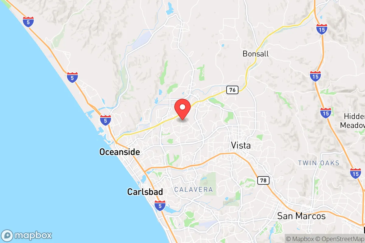
Oceanside sits at the northern edge of San Diego County, roughly 35 miles north of downtown San Diego and 85 miles south of Los Angeles. That puts it in a narrow coastal corridor that is both a strategic asset and a liability. On the plus side, the area enjoys a Mediterranean climate with mild winters and dry summers, meaning temperature extremes are rarely a survival threat. Average highs hover in the 60s and 70s year-round, which reduces the need for heavy heating or cooling infrastructure—a real advantage if the grid goes down. The Pacific Ocean provides a nearly limitless source of water, though desalination requires energy and equipment most households won't have. The Santa Margarita River runs through the northern part of the city, and the San Luis Rey River cuts through the center, offering potential surface water sources, though both are heavily managed and subject to drought restrictions. The terrain is a mix of flat coastal plain and low foothills, with the Santa Ana Mountains rising to the east. That eastern ridgeline offers some natural defensibility—anyone approaching from inland must cross the 15 or 5 corridors, which become natural chokepoints. For a prepper, the key takeaway is that Oceanside is not a remote hideout; it's a coastal town with decent natural resources but heavy human traffic.
Risks, exposures, and proximity to fallout-relevant landmarks
The biggest strategic liability is Camp Pendleton, the massive Marine Corps base that borders Oceanside to the north and east. The base covers roughly 125,000 acres and is home to over 37,000 active-duty personnel and their families. In a major civil unrest or mass casualty event, Pendleton becomes a double-edged sword. On one hand, it's a source of organized military power that could restore order or provide humanitarian aid. On the other, it's a high-value target for any adversary—whether foreign or domestic—and its presence makes Oceanside a likely staging area for military operations. If the base is locked down or compromised, the surrounding civilian population could be cut off or drawn into conflict. Additionally, the San Onofre Nuclear Generating Station (SONGS) sits about 15 miles up the coast, just north of Pendleton. While decommissioned, the site still stores spent nuclear fuel in dry casks. A major earthquake or deliberate attack on that facility could render large portions of the coastal zone uninhabitable for years. Oceanside is also within the blast radius of the Port of San Diego and Naval Base San Diego, both of which are prime targets for a coordinated strike. For the prepper, the calculus is simple: you are living next to a military base, near a nuclear waste site, and within striking distance of two major population centers. That is not a low-risk position.
Practical resilience for a relocator: food, water, energy, and defensibility
Water is the first concern. Oceanside gets its municipal supply from the Metropolitan Water District of Southern California, which imports water from the Colorado River and the State Water Project. That system is vulnerable to earthquake disruption, cyberattack, or political collapse. A household without a private well or rainwater catchment system is entirely dependent on a fragile, centralized infrastructure. The Santa Margarita and San Luis Rey rivers are perennial but heavily regulated, and accessing them legally during a crisis may be impossible. A prepper should plan for at least two weeks of stored water per person, and ideally a Berkey or similar gravity filter for local sources. Food is less of a problem in the short term. The area has numerous grocery stores, but supply chains in Southern California are notoriously fragile—the 2023 storms showed that even moderate flooding can empty shelves for days. Long-term, the climate supports year-round gardening, but soil quality is variable and water restrictions are common. Backyard chickens are legal in most of Oceanside, but livestock larger than that is restricted. Energy is a weak point. The grid in coastal San Diego County is prone to Public Safety Power Shutoffs (PSPS) during Santa Ana wind events, and the region has no meaningful backup generation at the household level. Solar with battery storage is a strong option here—the area gets over 260 sunny days per year—but it requires upfront investment and assumes the panels survive a seismic event. Defensibility is poor. Oceanside is a dense suburban environment with a grid street pattern and limited natural cover. A single-family home on a quarter-acre lot offers some buffer, but the average lot size is small. The best defensive position would be a property on the eastern edge of town, near the foothills, with a clear line of sight to approach routes. In a collapse scenario, the coast becomes a funnel—people will move toward the water, and Oceanside will be a chokepoint.
The overall strategic picture for Oceanside is one of calculated risk. It offers a mild climate, access to the ocean, and proximity to a major military installation that could be either a stabilizer or a target. For the conservative prepper who values community and infrastructure, it's not a bad place to ride out a short-term disruption—say, a week-long grid outage or a localized civil disturbance. But for a long-term collapse scenario involving national-scale unrest, supply chain failure, or a major geopolitical event, Oceanside's location next to Camp Pendleton, near a nuclear waste site, and within striking distance of two major cities makes it a high-exposure zone. The smart play here is to treat Oceanside as a temporary holding position, not a final bug-out location. If you're already here, invest in water storage, solar backup, and a solid evacuation plan that moves you east into the mountains or north toward less populated areas. If you're considering relocating here, understand that you are trading convenience and climate for proximity to risk. That trade may be acceptable for a family with young children who need schools and jobs, but it is not a survivalist's paradise. Oceanside is a coastal suburb with a military neighbor—prepare accordingly.
* Values derived from national, state, county, city and local statistics and may differ in a specific area. Last updated: 2026-04-24T14:29:58.000Z
Narrative content on this page is AI-generated and may contain mistakes. Verify any details that matter before acting on them.
ReloMaps may earn a commission from affiliate links at no extra cost to you.