
Photo: Mary Hammel via Unsplash
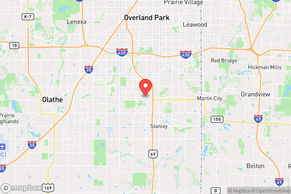
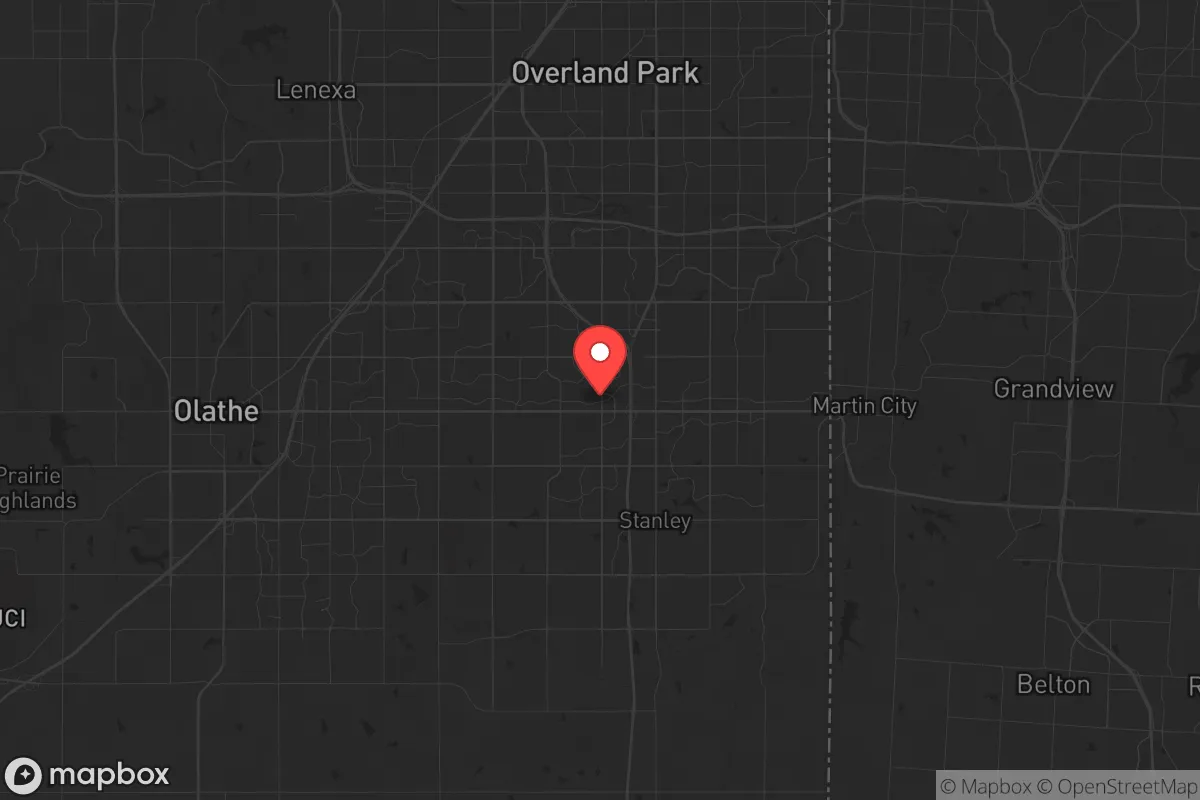
Strategic Assessment of Overland Park, KS
Multiple tactical vulnerabilities. Population density, target proximity, or disaster risk are likely compounding. A retreat property and exit planning is required.
What does the Strategic Assessment tell us?
Our Strategic Assessment grades tactical survivability of an area. Major population centers, military targets, fallout zones, natural disasters, and border exposure all drive risk — lower exposure means a more defensible position in a crisis.
This is heavily inspired by Joel Skousen's Strategic Relocation book. Highly recommended you checkout the book ($)What does this tell us?
Our Strategic Assessment grades tactical survivability of an area. Major population centers, military targets, fallout zones, natural disasters, and border exposure all drive risk — lower exposure means a more defensible position in a crisis.
This is heavily inspired by Joel Skousen's Strategic Relocation book. Highly recommended you checkout the book ($)Strategic Pillars

Key Distances
Regional Safe Places
Below is our recommended "safe zones" in Kansas and the surrounding area based on our strategic heuristics. For most people, it's unrealistic to live in a “safe zone” full-time due to work, family or other personal reasons. They tend to be more rural. However, many of these areas are perfect for second homes and retreat properties that double as a vacation home or even a short-term rental.
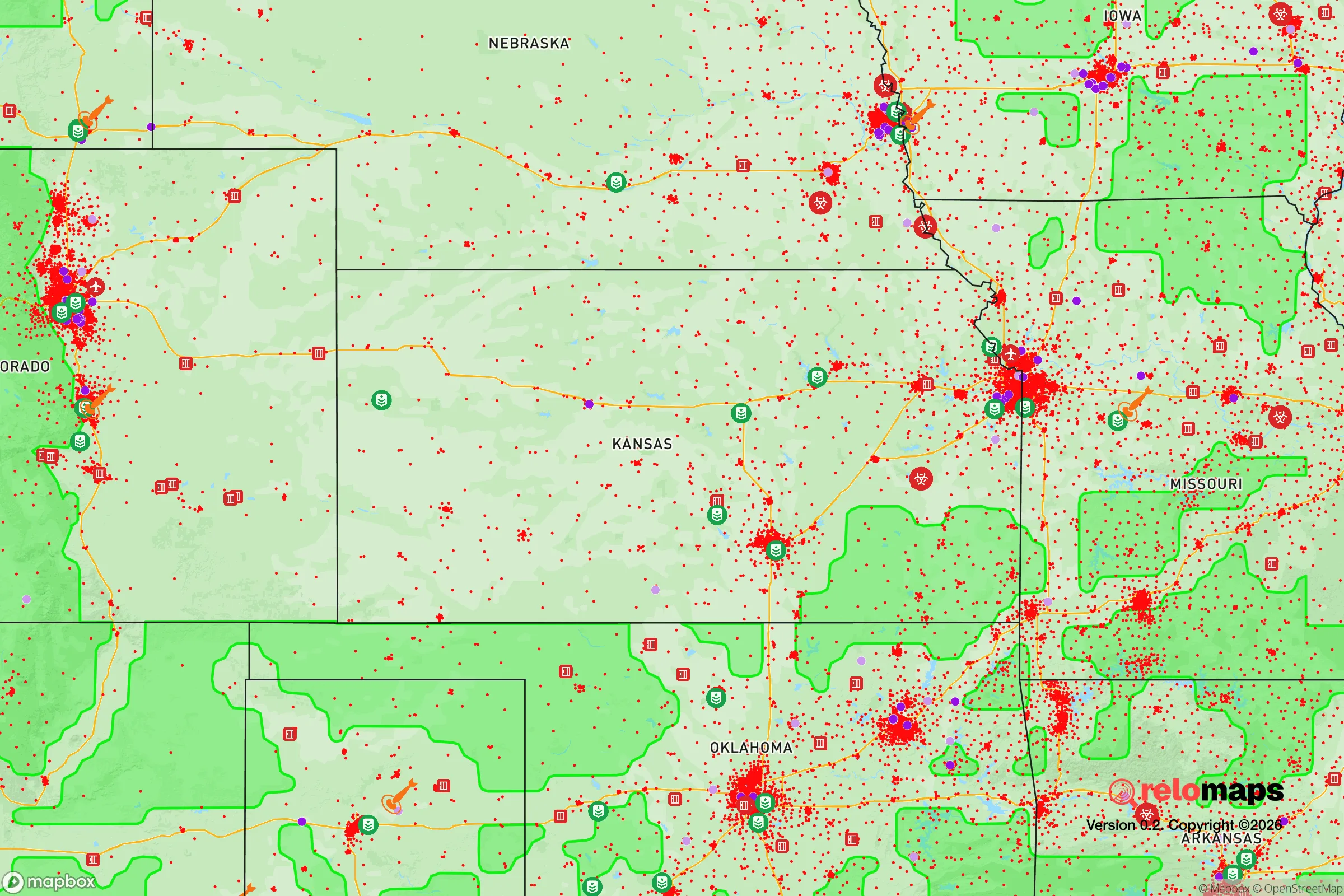
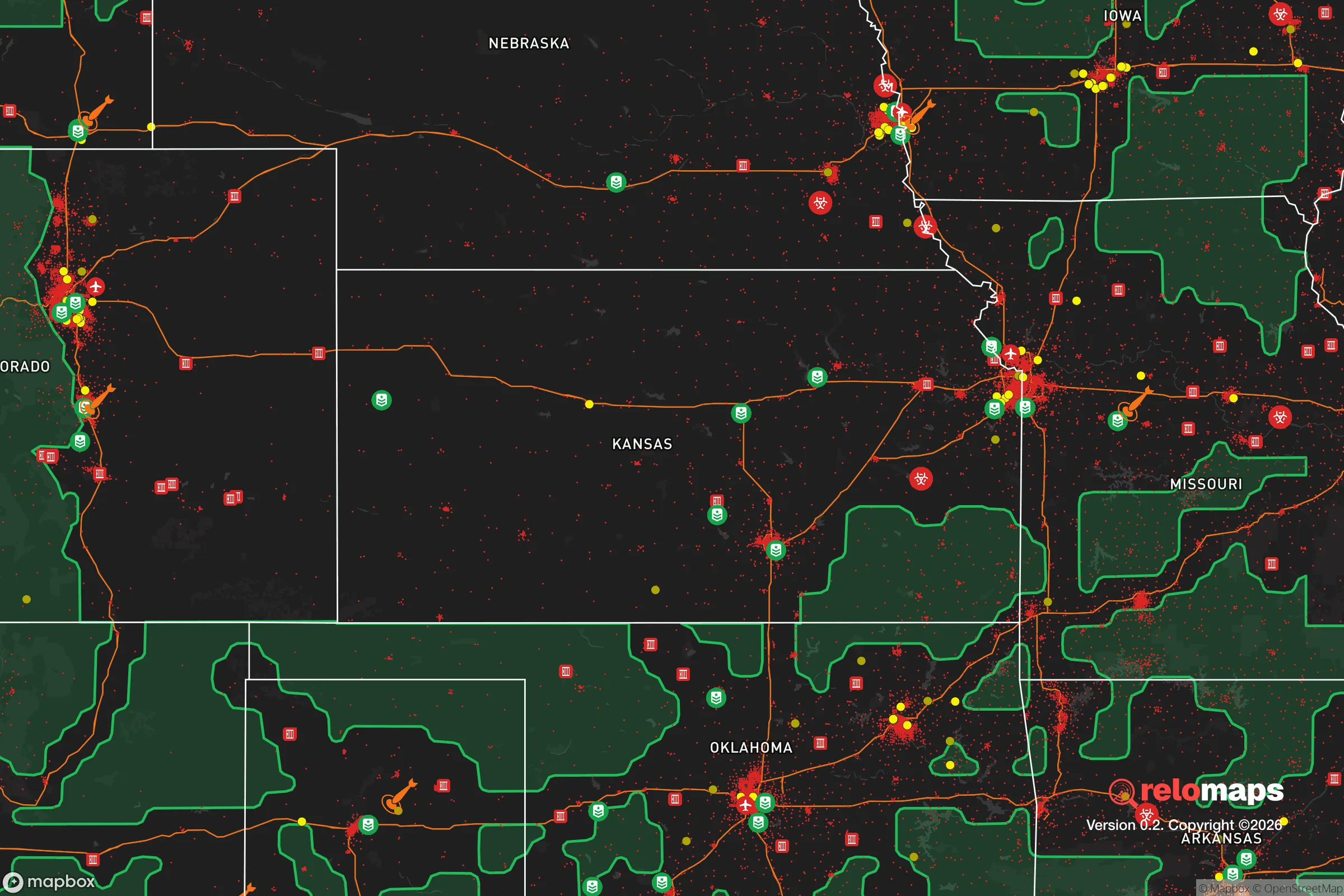
Important Note: For informational purposes only. This does not mean nothing bad ever happens in the green zones. Please use common sense. This is based on public data and modeled with AI. We tried to take a conservative approach but mistakes happen. We update this regularly as new information becomes available.
Solar Generator Recommendations
Backup power matters more here than in safer locations. We've picked three solar generators across budgets and capacity tiers — start with the budget unit if you only need a few essentials, or step up if you want to run a fridge and HVAC for days at a time.

Jackery Portable Power Station Explorer 300
Budget OptionPower on the Go: Weighing only 11 lbs, it's convenient to set up and store with book-sized foldable solar panels

BLUETTI Portable Power Station AC180
Designed for both indoor and outdoor scenarios, AC180 is highly capable as it has a robost capacity and continuous output power.

EF ECOFLOW DELTA Pro Ultra Power Station
Upgraded PickEcoFlow DELTA Pro Ultra is a whole-home energy system designed to grow with your family. Integrated with the Smart Home Panel 2, it scales to meet your evolving energy needs — keeping your home powered, intelligent, and secure through every stage of life.
We earn a commission, at no additional cost to you.
Strategic Assessment Analysis
Overland Park, Kansas, offers a deceptive blend of suburban comfort and strategic depth that makes it a serious contender for relocation-minded conservatives who prioritize resilience. Its position in the Kansas City metro area provides access to major infrastructure—Interstates 35, 435, and 69, plus a major international airport—while the city itself sits far enough from the urban core to avoid the worst of a metropolitan collapse. The area’s economic base is diversified across healthcare, finance, and technology, with major employers like Sprint (now T-Mobile), Garmin, and the University of Kansas Health System anchoring local stability. This isn’t a rural redoubt, but for those who want proximity to resources without being trapped in a densely populated target zone, Overland Park is a calculated middle ground.
Geographic position and natural advantages for long-term security
Overland Park sits in northeastern Kansas, roughly 15 miles southwest of downtown Kansas City, Missouri. The terrain is gently rolling plains with wooded creek valleys—not dramatic, but defensible in a practical sense. The area is part of the Osage Cuesta region, with limestone bedrock that provides stable foundations for underground shelters or root cellars. The Kansas River and Missouri River are within 20 miles, offering water sources, though both are heavily trafficked and potentially contaminated in a crisis. The region’s climate is continental: hot, humid summers and cold, snowy winters, which means any prepper setup must account for both extremes. The lack of major fault lines, hurricanes, or wildfire corridors is a genuine advantage—natural disasters here are limited to occasional tornadoes and ice storms, which are predictable and survivable with basic preparation. The surrounding farmland—Johnson County is still dotted with working farms—offers a buffer zone and potential for local food sourcing that urban areas lack.
Risks, exposures, and proximity to fallout-relevant landmarks
The biggest strategic liability is Overland Park’s location within the Kansas City metropolitan area, home to over 2.3 million people. In a mass casualty event or civil unrest scenario, the city’s population density—roughly 3,000 people per square mile—means that panic-driven evacuation routes (I-35, I-435) will gridlock within hours. The city is also within 30 miles of several high-value targets: the National Security Agency’s Kansas City facility, the BNSF Railway’s Argentine Yard (a major rail hub), and the Kansas City International Airport. A coordinated attack or EMP event could disrupt supply chains and communications for weeks. Additionally, the nearby Sunflower Army Ammunition Plant in De Soto (20 miles west) is a former munitions facility with residual contamination risks. On the plus side, Overland Park’s suburban layout—with cul-de-sacs, greenbelts, and a network of parks—offers natural chokepoints and defensible neighborhoods, provided you’re not on a main arterial road. The city’s police force is well-funded (Johnson County has one of the highest median incomes in the state), but in a prolonged crisis, law enforcement will likely be overwhelmed by the sheer scale of the metro area.
Practical resilience for a relocator: food, water, energy, and defensibility
For a single individual or family serious about preparedness, Overland Park has both strengths and gaps. Water: The city draws from the Missouri River via the Kansas City Water District, but a grid-down scenario means relying on private wells (common in older subdivisions) or stored rainwater. The average annual rainfall is 38 inches, so rainwater catchment is viable, but you’ll need filtration for surface water. Food: Johnson County has a robust farmers’ market scene (the Overland Park Farmers Market runs April through October), and local CSAs can provide fresh produce. However, the area is not a major agricultural producer—most grain and livestock operations are west of here. Stockpiling non-perishables is essential, and the presence of Costco, Sam’s Club, and multiple grocery chains makes bulk buying easy in normal times. Energy: The grid is reliable but vulnerable to ice storms and cyberattacks. Solar panels are increasingly common, and the state offers net metering, but zoning in some HOAs restricts visible installations. Natural gas is the primary heating fuel, which is a double-edged sword—it’s efficient but dependent on pipeline infrastructure. Defensibility: Overland Park’s suburban design works in your favor if you choose a home on a cul-de-sac or near a greenway. The city has a low violent crime rate (roughly 1.5 per 1,000 residents), but property crime is higher—car break-ins and package theft are common. In a collapse scenario, the biggest threat isn’t roaming gangs but desperate neighbors from less-prepared parts of the metro. Building a community of like-minded families is the single most effective resilience strategy here; Johnson County has a strong church and civic network that can serve as a trust foundation.
The overall strategic picture for Overland Park is one of calculated risk. It’s not a remote survivalist haven—you’re still within striking distance of a major city’s problems. But for a conservative relocator who wants a stable job market, good schools, and a community that values self-reliance, it’s a solid base of operations. The key is to treat it as a launch point, not a fortress. Keep a bug-out vehicle gassed up, maintain a 90-day supply of food and water, and establish relationships with neighbors before the crisis hits. The area’s biggest advantage is its ordinariness—it doesn’t scream “prepper,” which means you can fly under the radar while quietly building your resilience. If you’re looking for a place that balances suburban comfort with genuine strategic depth, Overland Park deserves a hard look. Just don’t mistake its manicured lawns for safety—prepare accordingly.
* Values derived from national, state, county, city and local statistics and may differ in a specific area. Last updated: 2026-04-29T18:33:19.000Z
Narrative content on this page is AI-generated and may contain mistakes. Verify any details that matter before acting on them.
ReloMaps may earn a commission from affiliate links at no extra cost to you.