Photo: Wikipedia
Strategic Assessment of Pflugerville, TX
Multiple tactical vulnerabilities. Population density, target proximity, or disaster risk are likely compounding. A retreat property and exit planning is required.
What does the Strategic Assessment tell us?
Our Strategic Assessment grades tactical survivability of an area. Major population centers, military targets, fallout zones, natural disasters, and border exposure all drive risk — lower exposure means a more defensible position in a crisis.
This is heavily inspired by Joel Skousen's Strategic Relocation book. Highly recommended you checkout the book ($)What does this tell us?
Our Strategic Assessment grades tactical survivability of an area. Major population centers, military targets, fallout zones, natural disasters, and border exposure all drive risk — lower exposure means a more defensible position in a crisis.
This is heavily inspired by Joel Skousen's Strategic Relocation book. Highly recommended you checkout the book ($)Strategic Pillars

Key Distances
Regional Safe Places
Below is our recommended "safe zones" in Texas and the surrounding area based on our strategic heuristics. For most people, it's unrealistic to live in a “safe zone” full-time due to work, family or other personal reasons. They tend to be more rural. However, many of these areas are perfect for second homes and retreat properties that double as a vacation home or even a short-term rental.


Important Note: For informational purposes only. This does not mean nothing bad ever happens in the green zones. Please use common sense. This is based on public data and modeled with AI. We tried to take a conservative approach but mistakes happen. We update this regularly as new information becomes available.
Solar Generator Recommendations
Backup power matters more here than in safer locations. We've picked three solar generators across budgets and capacity tiers — start with the budget unit if you only need a few essentials, or step up if you want to run a fridge and HVAC for days at a time.

Jackery Portable Power Station Explorer 300
Budget OptionPower on the Go: Weighing only 11 lbs, it's convenient to set up and store with book-sized foldable solar panels

BLUETTI Portable Power Station AC180
Designed for both indoor and outdoor scenarios, AC180 is highly capable as it has a robost capacity and continuous output power.

EF ECOFLOW DELTA Pro Ultra Power Station
Upgraded PickEcoFlow DELTA Pro Ultra is a whole-home energy system designed to grow with your family. Integrated with the Smart Home Panel 2, it scales to meet your evolving energy needs — keeping your home powered, intelligent, and secure through every stage of life.
We earn a commission, at no additional cost to you.
Strategic Assessment Analysis
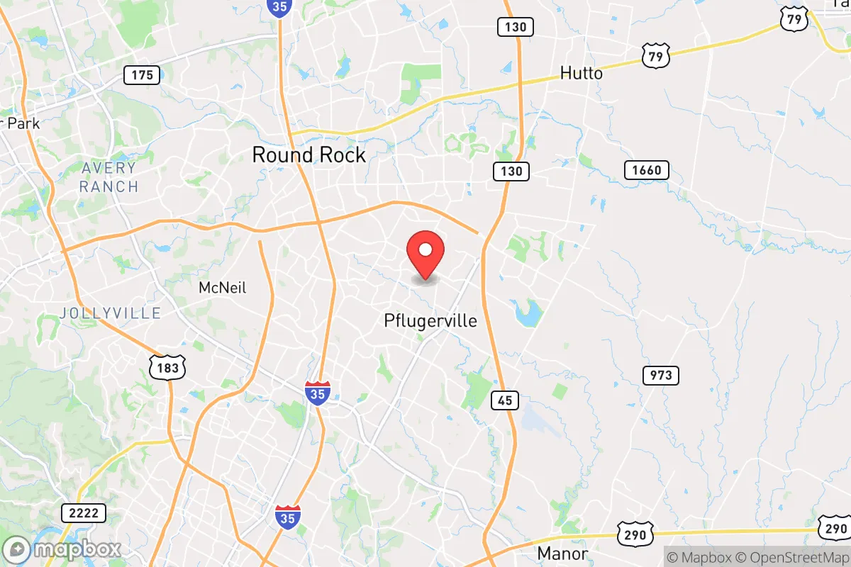
Pflugerville, Texas, sits in a precarious but potentially advantageous position for those serious about strategic relocation. Its location just northeast of Austin offers a buffer from the immediate chaos of a major urban center while still providing access to critical infrastructure, but that proximity is a double-edged sword. For the prepper or survivalist, Pflugerville’s resilience hinges on its ability to function as a semi-independent node—close enough to tap resources, far enough to avoid the worst of a collapse. The area’s rapid growth, from roughly 65,000 residents in 2020 to an estimated 80,000 by 2026, has strained local services, but its position along the I-35 corridor and near the Colorado River basin gives it a logistical edge that can’t be ignored.
Geographic position and natural advantages for long-term survival
Pflugerville’s geography is a mixed bag for the strategic relocator. It sits on the eastern edge of the Texas Hill Country, where the terrain transitions from rolling limestone hills to flatter Blackland Prairie. This gives you decent elevation—around 700 feet above sea level—which reduces flood risk compared to low-lying Austin neighborhoods, but it’s not mountainous enough to offer true defensibility. The area benefits from the Balcones Fault Zone, which provides natural water springs and aquifer recharge zones; the Edwards Aquifer is a major water source, though it’s heavily tapped by Austin and San Antonio. For a prepper, this means groundwater access is possible but requires deep wells—typically 200 to 400 feet—and permits are competitive. The climate is semi-arid, with average annual rainfall around 34 inches, enough for rain catchment systems but not enough to guarantee year-round surface water without storage. The Colorado River, about 10 miles southwest, is a reliable water source, but it’s also a target for contamination from upstream industrial sites and potential fallout from Austin’s infrastructure. The natural vegetation—live oaks, junipers, and mesquite—provides decent cover and firewood, but the lack of dense forests means you’ll need to plan for concealment. Overall, the area’s natural advantages are moderate: good for a small-scale homestead with well water and solar, but not ideal for a fully off-grid setup without significant investment.
Risks, exposures, and proximity to fallout-relevant landmarks
The biggest risk for Pflugerville is its proximity to Austin, a major population center and political target. Austin is home to the Texas State Capitol, the University of Texas, and a dense concentration of tech infrastructure, including data centers for companies like Apple and Google. In a scenario of civil unrest or mass casualty events, these landmarks become magnets for looting, riots, or even targeted attacks. Pflugerville is only 15 miles from downtown Austin, meaning fallout from a major event—whether a dirty bomb, EMP, or coordinated attack—could reach the area within hours. The I-35 corridor, which runs through Pflugerville, is a critical evacuation route but also a choke point; during a crisis, it would likely be gridlocked or blocked by military checkpoints. The Austin-Bergstrom International Airport, about 20 miles south, is another high-risk landmark, as it could be a target for air-based threats or a staging ground for federal response. Additionally, the nearby Dell Diamond stadium and the Pflugerville ISD’s large campuses could be used as FEMA-style assembly points, drawing unwanted attention. On the positive side, the area has fewer obvious industrial hazards than Houston or Dallas—no major chemical plants or nuclear reactors within 50 miles—but the South Texas Nuclear Generating Station near Bay City is about 150 miles away, and prevailing winds from the south could carry fallout in a worst-case scenario. The risk profile is moderate-high: you’re not in the blast zone, but you’re in the zone of secondary effects.
Practical resilience for a relocator: food, water, energy, and defensibility
For a relocator focused on practical resilience, Pflugerville offers a mixed but workable foundation. Water is the most critical factor: municipal water comes from the Colorado River via the Lower Colorado River Authority, but this system is vulnerable to contamination and disruption. A prepper should plan for a private well (costing $15,000 to $30,000 to drill) and a rainwater catchment system with at least 5,000 gallons of storage. The soil is mostly clay-heavy, which is poor for drainage but good for building earth-sheltered structures. Food production is feasible but not easy: the growing season runs from March to November, and you can raise chickens, goats, or even a small herd of cattle on 5-10 acres, but land prices have skyrocketed—expect $50,000 to $100,000 per acre for undeveloped plots. Community gardens and local farms like the Pflugerville Community Garden offer some redundancy, but they’re not secure in a crisis. Energy is a bright spot: Texas’s deregulated grid means you can install solar panels with battery storage (Tesla Powerwall or similar) and stay off-grid for most needs, but the ERCOT grid is notoriously fragile during winter storms, as seen in 2021. A backup propane generator is a must. Defensibility is the weak link: Pflugerville is a suburban sprawl with few natural chokepoints. Your best bet is a property on the eastern edge, near the Blackland Prairie, where larger lots (1-5 acres) offer more buffer from neighbors. The local police department has about 60 officers, but response times in a crisis could stretch to hours. The gun culture is strong—Texas has constitutional carry—and there are several gun ranges and shops within 10 miles, like the Pflugerville Gun Club. For a single individual or family, the key is to buy land with a well, solar, and a defensible perimeter, ideally on a dead-end road. The area’s biggest advantage is its community of like-minded preppers; there are active Facebook groups and local meetups for survivalists, which can be a force multiplier for mutual aid.
The overall strategic picture for Pflugerville is one of calculated risk. It’s not a bug-out location—it’s too close to Austin for that—but it can work as a “bug-in” base if you’re willing to invest in hardening. The area’s growth is both a threat and an opportunity: more people mean more eyes on the street, but also more competition for resources. For a conservative-leaning relocator who values self-reliance and community, Pflugerville offers a middle ground between urban access and rural isolation. The key is to treat it as a staging ground—build your supplies, network with locals, and have a secondary retreat plan for the Hill Country or East Texas if things go south. The state’s political climate is favorable for preppers, with lax zoning laws and strong property rights, but don’t underestimate the logistical challenges of suburban survival. If you’re serious about resilience, Pflugerville is a viable option—but only if you’re prepared to treat it as a base of operations, not a final destination.
* Values derived from national, state, county, city and local statistics and may differ in a specific area. Last updated: 2026-04-19T07:22:28.000Z
Narrative content on this page is AI-generated and may contain mistakes. Verify any details that matter before acting on them.
ReloMaps may earn a commission from affiliate links at no extra cost to you.