
Photo: Nils Huenerfuerst via Unsplash
Strategic Assessment of Pleasant Valley, WV
Meaningful friction. Expect exposure to either population pressure, blast zones, or natural disaster risk. Consider buying a retreat property.
What does the Strategic Assessment tell us?
Our Strategic Assessment grades tactical survivability of an area. Major population centers, military targets, fallout zones, natural disasters, and border exposure all drive risk — lower exposure means a more defensible position in a crisis.
This is heavily inspired by Joel Skousen's Strategic Relocation book. Highly recommended you checkout the book ($)What does this tell us?
Our Strategic Assessment grades tactical survivability of an area. Major population centers, military targets, fallout zones, natural disasters, and border exposure all drive risk — lower exposure means a more defensible position in a crisis.
This is heavily inspired by Joel Skousen's Strategic Relocation book. Highly recommended you checkout the book ($)Strategic Pillars

Key Distances
Regional Safe Places
Below is our recommended "safe zones" in West Virginia and the surrounding area based on our strategic heuristics. For most people, it's unrealistic to live in a “safe zone” full-time due to work, family or other personal reasons. They tend to be more rural. However, many of these areas are perfect for second homes and retreat properties that double as a vacation home or even a short-term rental.


Important Note: For informational purposes only. This does not mean nothing bad ever happens in the green zones. Please use common sense. This is based on public data and modeled with AI. We tried to take a conservative approach but mistakes happen. We update this regularly as new information becomes available.
Solar Generator Recommendations
Backup power matters more here than in safer locations. We've picked three solar generators across budgets and capacity tiers — start with the budget unit if you only need a few essentials, or step up if you want to run a fridge and HVAC for days at a time.

Jackery Portable Power Station Explorer 300
Budget OptionPower on the Go: Weighing only 11 lbs, it's convenient to set up and store with book-sized foldable solar panels

BLUETTI Portable Power Station AC180
Designed for both indoor and outdoor scenarios, AC180 is highly capable as it has a robost capacity and continuous output power.

EF ECOFLOW DELTA Pro Ultra Power Station
Upgraded PickEcoFlow DELTA Pro Ultra is a whole-home energy system designed to grow with your family. Integrated with the Smart Home Panel 2, it scales to meet your evolving energy needs — keeping your home powered, intelligent, and secure through every stage of life.
We earn a commission, at no additional cost to you.
Strategic Assessment Analysis
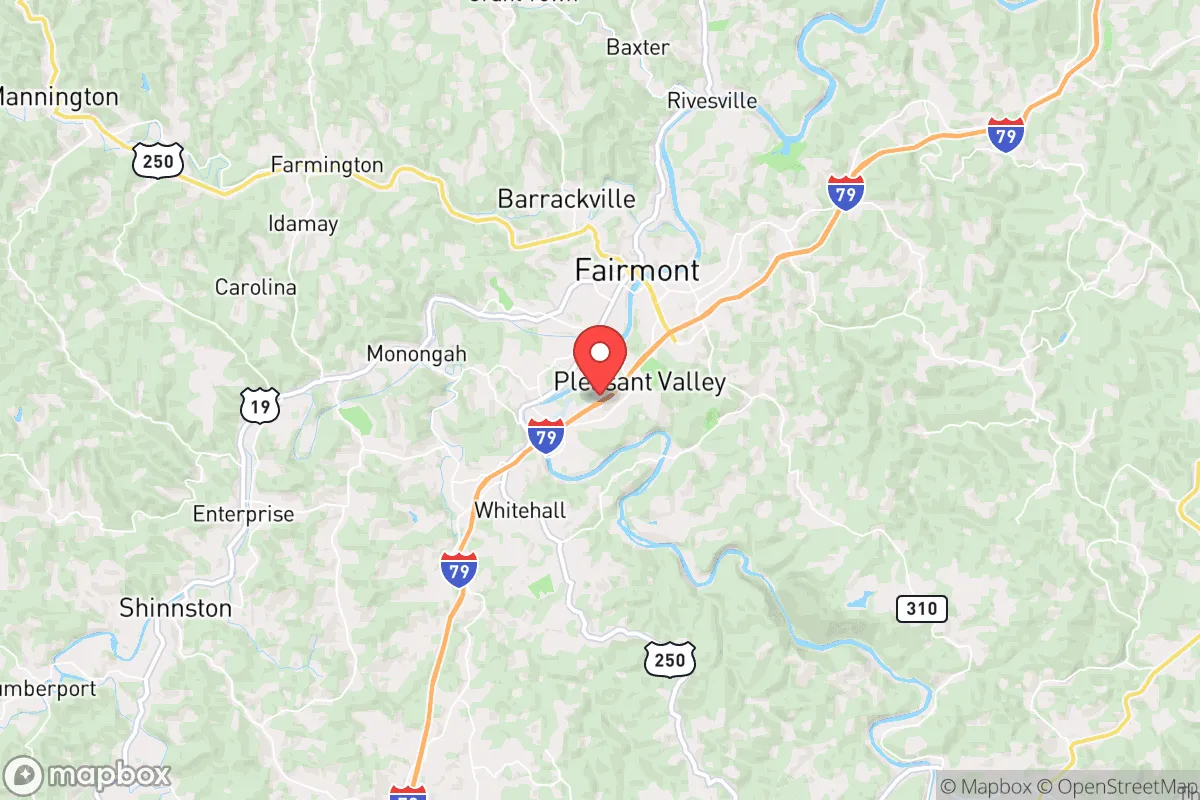
Pleasant Valley, West Virginia, sits in a geographic sweet spot that offers genuine strategic depth for those serious about resilience, without the isolation that makes daily life impractical. Nestled in Marion County, this small community benefits from the rugged terrain of the Appalachian foothills, which naturally filters out much of the chaos radiating from the Eastern Seaboard. For a relocator thinking in terms of decades, not just the next election cycle, Pleasant Valley provides a defensible, resource-rich base that is close enough to essential infrastructure but far enough from the fallout zones of major population centers.
Geographic position and natural advantages for long-term security
Pleasant Valley’s location is its primary strategic asset. It sits roughly 90 miles south of Pittsburgh and about 150 miles west of Washington, D.C.—close enough to access major medical and supply hubs in a stable period, but far enough that a cascading failure in those metros would likely bypass the area. The surrounding landscape is a mix of forested hills and narrow valleys, which creates natural chokepoints and limits lines of sight. This terrain makes large-scale movement difficult for any organized threat, while offering numerous positions for observation and defense. The area is also within the Monongahela National Forest watershed, meaning water sources are plentiful and relatively protected from upstream contamination. For a prepper, this is the kind of geography that rewards local knowledge and punishes outsiders—exactly the dynamic you want when society gets thin.
Risks, exposures, and proximity to fallout-relevant landmarks
No location is without risk, and Pleasant Valley has a few hard realities to consider. The most immediate concern is the proximity to the Morgantown metropolitan area, about 20 miles north. Morgantown is home to West Virginia University and a regional medical center—both valuable in normal times, but both potential targets or chokepoints during civil unrest. The area also sits within 100 miles of the Fort Necessity National Battlefield and several historical industrial sites, but the more pressing modern risk is the network of natural gas pipelines and storage fields that crisscross northern West Virginia. A major pipeline rupture or targeted attack could disrupt local energy supplies and draw unwanted attention. Additionally, the region is in a moderate seismic zone, and while major earthquakes are rare, the aging infrastructure of dams and bridges in the area could become liabilities in a prolonged grid-down scenario. The good news is that Pleasant Valley itself is not near any known nuclear power plants or major military installations, which significantly reduces the risk of being in a primary or secondary fallout zone. The bad news is that the area’s relative obscurity means emergency services are thin—Marion County’s sheriff’s office and volunteer fire departments are capable but stretched thin, so self-reliance is not optional here; it’s the baseline expectation.
Practical resilience for a relocator: food, water, energy, and defensibility
For a relocator serious about self-sufficiency, Pleasant Valley offers a workable foundation. Water is the first concern, and the area’s numerous creeks and springs—many fed by the Tygart Valley River watershed—provide reliable surface water. However, testing and filtration are non-negotiable, as agricultural runoff and legacy mining contamination can affect local sources. A deep well with a hand pump is the gold standard here, and many older properties already have them. Food production is viable: the growing season runs about 150 days, and the soil in the valley bottoms is decent for gardens, though hillside plots require terracing. Local farmers’ markets in Fairmont and Morgantown offer seed stock and livestock, but a serious prepper should plan to establish a closed-loop system within two to three years. Energy is a mixed bag. The grid is moderately reliable but prone to outages during winter storms. Solar is viable, but the tree canopy and frequent cloud cover mean you’ll need a larger array than you would in the Southwest. Wood heat is the practical backup—most homes have fireplaces or wood stoves, and the surrounding forests provide ample fuel if you have a chainsaw and the lungs to work it. Defensibility is where Pleasant Valley shines. The valley itself is narrow, with only a few roads in and out, and the surrounding ridges offer natural observation points. A small, organized group could effectively control access to the immediate area, and the lack of major highways means that transient threats are less likely to pass through. That said, the community is small enough that you’ll need to build relationships—being the lone prepper on the hill works in fiction, but in a real crisis, mutual aid with neighbors is the difference between thriving and just surviving.
The overall strategic picture for Pleasant Valley is one of cautious optimism for the prepared relocator. It is not a bug-out location for a weekend; it is a place to build a life that can withstand the shocks of the coming decades. The risks are real—proximity to regional metros, aging infrastructure, and the ever-present threat of resource competition during a collapse—but the natural advantages of terrain, water, and relative isolation outweigh them for someone willing to put in the work. For the conservative-leaning individual or family who sees the writing on the wall and wants a base that is both livable now and defensible later, Pleasant Valley deserves a serious look. It is not paradise, but it is a place where preparation meets practicality, and that is the best you can ask for in an uncertain world.
* Values derived from national, state, county, city and local statistics and may differ in a specific area. Last updated: 2026-04-23T05:44:32.000Z
Narrative content on this page is AI-generated and may contain mistakes. Verify any details that matter before acting on them.
ReloMaps may earn a commission from affiliate links at no extra cost to you.