
Photo: Wikipedia
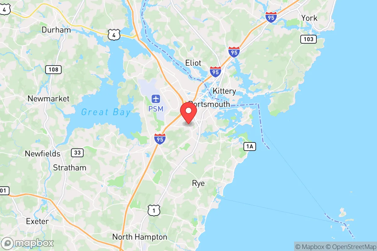
Strategic Assessment of Portsmouth, NH
Multiple tactical vulnerabilities. Population density, target proximity, or disaster risk are likely compounding. A retreat property and exit planning is required.
What does the Strategic Assessment tell us?
Our Strategic Assessment grades tactical survivability of an area. Major population centers, military targets, fallout zones, natural disasters, and border exposure all drive risk — lower exposure means a more defensible position in a crisis.
This is heavily inspired by Joel Skousen's Strategic Relocation book. Highly recommended you checkout the book ($)What does this tell us?
Our Strategic Assessment grades tactical survivability of an area. Major population centers, military targets, fallout zones, natural disasters, and border exposure all drive risk — lower exposure means a more defensible position in a crisis.
This is heavily inspired by Joel Skousen's Strategic Relocation book. Highly recommended you checkout the book ($)Strategic Pillars

Key Distances
Regional Safe Places
Below is our recommended "safe zones" in New Hampshire and the surrounding area based on our strategic heuristics. For most people, it's unrealistic to live in a “safe zone” full-time due to work, family or other personal reasons. They tend to be more rural. However, many of these areas are perfect for second homes and retreat properties that double as a vacation home or even a short-term rental.


Important Note: For informational purposes only. This does not mean nothing bad ever happens in the green zones. Please use common sense. This is based on public data and modeled with AI. We tried to take a conservative approach but mistakes happen. We update this regularly as new information becomes available.
Solar Generator Recommendations
Backup power matters more here than in safer locations. We've picked three solar generators across budgets and capacity tiers — start with the budget unit if you only need a few essentials, or step up if you want to run a fridge and HVAC for days at a time.

Jackery Portable Power Station Explorer 300
Budget OptionPower on the Go: Weighing only 11 lbs, it's convenient to set up and store with book-sized foldable solar panels

BLUETTI Portable Power Station AC180
Designed for both indoor and outdoor scenarios, AC180 is highly capable as it has a robost capacity and continuous output power.

EF ECOFLOW DELTA Pro Ultra Power Station
Upgraded PickEcoFlow DELTA Pro Ultra is a whole-home energy system designed to grow with your family. Integrated with the Smart Home Panel 2, it scales to meet your evolving energy needs — keeping your home powered, intelligent, and secure through every stage of life.
We earn a commission, at no additional cost to you.
Strategic Assessment Analysis
Portsmouth, New Hampshire, presents a complex strategic picture for the conservative prepper. Its coastal location and historic prosperity offer genuine resilience advantages, but its proximity to major metropolitan areas and critical infrastructure introduces significant vulnerabilities that demand careful consideration. For the individual or family prioritizing self-reliance and security in an era of potential civic unrest and systemic disruption, Portsmouth is less a sanctuary and more a high-value, high-risk outpost requiring constant vigilance and layered preparation.
Geographic position and natural advantages for long-term security
Portsmouth sits at the mouth of the Piscataqua River, a deep-water harbor that has historically been its economic engine. For the prepper, this location offers a mixed bag. The immediate area is surrounded by the Great Bay estuary and extensive tidal marshes, which provide natural barriers to large-scale ground movement from the south and west. The city itself is built on a peninsula, with the river to the east and the bay to the south, creating a defensible core if you control the bridges. The surrounding region—southeastern New Hampshire and southwestern Maine—is dotted with small towns, working forests, and agricultural land within a 30- to 45-minute drive. This means that while Portsmouth itself is dense and exposed, a relocator with a vehicle and a plan can access rural retreat zones relatively quickly. The climate is temperate, with four distinct seasons, reliable rainfall, and access to abundant freshwater from the Piscataqua and its tributaries. The region is not prone to earthquakes, hurricanes rarely make direct landfall here (though they can), and the local topography—low hills and mixed forest—offers decent concealment and natural resources for off-grid living. The biggest natural advantage is the proximity to the White Mountain National Forest, roughly 90 minutes north, which provides a massive, sparsely populated buffer zone and a potential fallback area for long-term survival scenarios.
Risks, exposures, and proximity to fallout-relevant landmarks
Here is where the analysis turns sobering. Portsmouth’s greatest strategic weakness is its proximity to high-value, high-risk targets. The city lies just 55 miles north of Boston, a primary economic and population center that would be a focal point for any major civil unrest, supply chain collapse, or mass casualty event. The I-95 corridor, which runs directly through Portsmouth, is a natural chokepoint and evacuation route that would become impassable in a crisis. More concerning for the prepper is the presence of the Portsmouth Naval Shipyard, located on Seavey Island just across the river in Kittery, Maine. This is a major U.S. Navy submarine repair and maintenance facility, housing nuclear-powered vessels. In a scenario involving state collapse, foreign conflict, or domestic terrorism, this facility is a high-probability target for sabotage, attack, or seizure. The shipyard employs thousands and generates constant heavy traffic, including hazardous material shipments. Additionally, the Seabrook Nuclear Power Station sits just 12 miles south of Portsmouth. While it is a civilian facility, its vulnerability to accident or attack—and the potential for a radiological release—places Portsmouth within the 10-mile emergency planning zone. The prevailing winds blow from the west and southwest, meaning any airborne contamination from Seabrook would likely drift directly over the city. For the survivalist, these two facilities alone make Portsmouth a location that demands a robust evacuation plan and a willingness to leave at a moment’s notice. The city’s reliance on a few bridge crossings (the Memorial Bridge, the Sarah Mildred Long Bridge, and the I-95 bridge) creates a single-point-of-failure vulnerability; if any of these are compromised, the city becomes a trap.
Practical resilience for a relocator: food, water, energy, and defensibility
For a relocator committed to staying in the Portsmouth area, practical resilience requires a deliberate, layered approach. Water is not a problem—the Piscataqua River is tidal and brackish, but the region has numerous freshwater ponds, streams, and municipal reservoirs. The city’s water supply comes from the Portsmouth Reservoir system and the Bellamy River, but a prepper should not rely on municipal infrastructure in a crisis. A well on a rural property within 20 minutes of the city is a wise investment. Food security is moderate. The immediate area has limited agricultural land—most of the Seacoast region is developed or forested. However, within a 30-minute drive, there are working farms, orchards, and community-supported agriculture operations. Stockpiling non-perishable food is essential, as local grocery stores would empty within hours of a panic event. Energy is a vulnerability. Portsmouth is connected to the regional grid, which is aging and subject to storm-related outages. Natural gas lines serve the city, but a determined adversary could target pipeline infrastructure. Solar panels with battery storage are viable here, though winter cloud cover reduces output. A backup generator with a secure fuel supply is non-negotiable. Defensibility is poor within the city itself. Portsmouth’s dense, walkable neighborhoods, narrow streets, and historic buildings offer limited fields of fire and many hiding places for threats. The city’s population of roughly 22,000 swells with tourists and seasonal workers, creating a transient population that complicates community trust. For a family, the best approach is to live on the outskirts—in towns like Newington, Greenland, or Rye—where you have more land, better sightlines, and the ability to harden a property. The local police and fire departments are professional but would be overwhelmed in a widespread event. The New Hampshire State Police and National Guard are assets, but response times to the Seacoast could be delayed if the crisis is statewide. Building a network of like-minded neighbors is the single most effective defensive measure; Portsmouth’s transient culture makes this harder than in rural areas.
The overall strategic picture for Portsmouth is one of calculated risk. It offers genuine advantages—a strong local economy, access to the ocean and forests, a relatively stable state government, and a community that values independence. But these are offset by its proximity to Boston, the naval shipyard, and the nuclear plant, as well as its dependence on fragile infrastructure and bridge crossings. For the conservative prepper who is willing to invest in a rural property within a 30-minute drive, maintain a fully stocked retreat, and develop a rapid evacuation plan, Portsmouth can serve as a functional base for work and community life. For anyone expecting to hunker down in the city itself and ride out a major disruption, the risks likely outweigh the rewards. The smart play is to treat Portsmouth as a forward operating base—not a fortress. Know your exits, keep your gear ready, and always have a plan B that points north into the White Mountains. That is the honest assessment for anyone serious about survival in this corner of New England.
* Values derived from national, state, county, city and local statistics and may differ in a specific area. Last updated: 2026-05-01T22:27:08.000Z
Narrative content on this page is AI-generated and may contain mistakes. Verify any details that matter before acting on them.
ReloMaps may earn a commission from affiliate links at no extra cost to you.