
Photo: Wikipedia
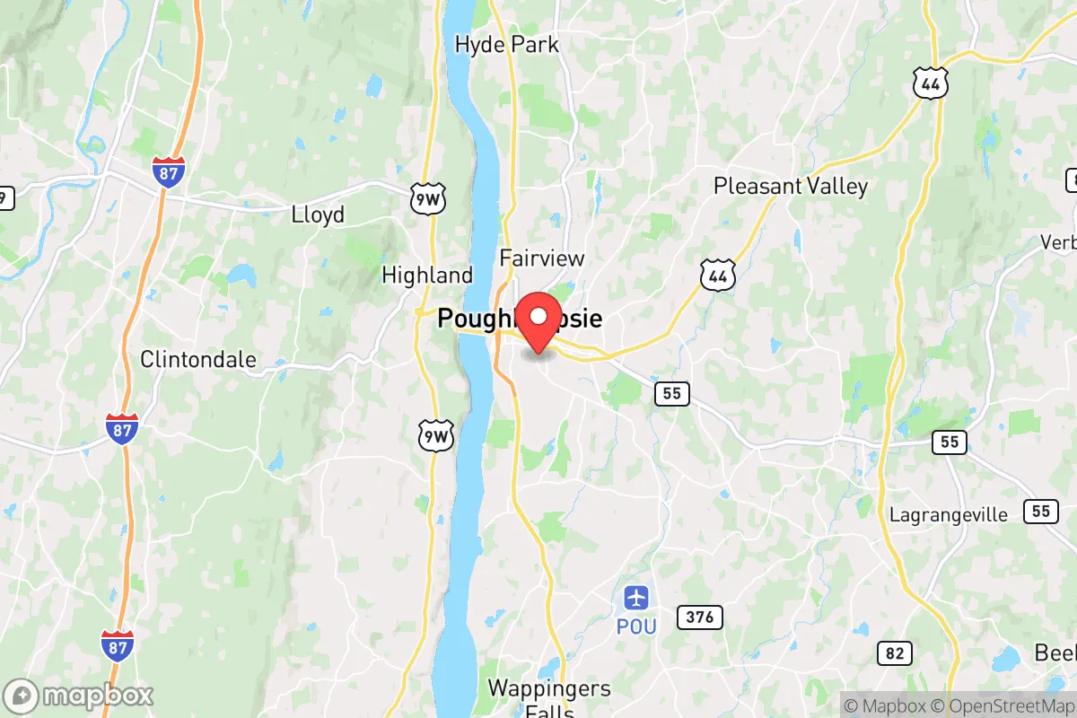
Strategic Assessment of Poughkeepsie, NY
Multiple tactical vulnerabilities. Population density, target proximity, or disaster risk are likely compounding. A retreat property and exit planning is required.
What does the Strategic Assessment tell us?
Our Strategic Assessment grades tactical survivability of an area. Major population centers, military targets, fallout zones, natural disasters, and border exposure all drive risk — lower exposure means a more defensible position in a crisis.
This is heavily inspired by Joel Skousen's Strategic Relocation book. Highly recommended you checkout the book ($)What does this tell us?
Our Strategic Assessment grades tactical survivability of an area. Major population centers, military targets, fallout zones, natural disasters, and border exposure all drive risk — lower exposure means a more defensible position in a crisis.
This is heavily inspired by Joel Skousen's Strategic Relocation book. Highly recommended you checkout the book ($)Strategic Pillars

Key Distances
Regional Safe Places
Below is our recommended "safe zones" in New York and the surrounding area based on our strategic heuristics. For most people, it's unrealistic to live in a “safe zone” full-time due to work, family or other personal reasons. They tend to be more rural. However, many of these areas are perfect for second homes and retreat properties that double as a vacation home or even a short-term rental.


Important Note: For informational purposes only. This does not mean nothing bad ever happens in the green zones. Please use common sense. This is based on public data and modeled with AI. We tried to take a conservative approach but mistakes happen. We update this regularly as new information becomes available.
Solar Generator Recommendations
Backup power matters more here than in safer locations. We've picked three solar generators across budgets and capacity tiers — start with the budget unit if you only need a few essentials, or step up if you want to run a fridge and HVAC for days at a time.

Jackery Portable Power Station Explorer 300
Budget OptionPower on the Go: Weighing only 11 lbs, it's convenient to set up and store with book-sized foldable solar panels

BLUETTI Portable Power Station AC180
Designed for both indoor and outdoor scenarios, AC180 is highly capable as it has a robost capacity and continuous output power.

EF ECOFLOW DELTA Pro Ultra Power Station
Upgraded PickEcoFlow DELTA Pro Ultra is a whole-home energy system designed to grow with your family. Integrated with the Smart Home Panel 2, it scales to meet your evolving energy needs — keeping your home powered, intelligent, and secure through every stage of life.
We earn a commission, at no additional cost to you.
Strategic Assessment Analysis
Poughkeepsie, New York, presents a complex strategic picture for the conservative prepper or survivalist. Its location along the Hudson River, roughly midway between New York City and Albany, offers a mix of advantages and severe liabilities. While the area possesses natural resources and a degree of geographic insulation from the most immediate blast zones, its proximity to major population centers, critical infrastructure, and potential fallout targets makes it a high-risk, high-reward proposition that demands careful, sober assessment. For the relocator prioritizing long-term resilience over convenience, Poughkeepsie is a location that requires a clear-eyed understanding of its vulnerabilities before any commitment is made.
Geographic position and natural advantages for long-term survival
Poughkeepsie’s primary strategic asset is its position within the Hudson Valley, a region rich in natural resources. The Hudson River itself provides a substantial water source, though its industrial history and potential for contamination from upstream or downstream events mean any reliance on it for drinking water would require robust, multi-stage filtration and treatment systems. The surrounding terrain, including the Taconic Mountains to the east and the Catskills to the west, offers defensible high ground and numerous rural pockets where a relocator could establish a more secure secondary position. The area’s agricultural capacity is notable: Dutchess County has a strong farming tradition, with orchards, dairy operations, and vegetable farms that could, in a prolonged crisis, provide a local food supply chain less dependent on national distribution networks. The climate, with four distinct seasons, supports a wide range of crops and livestock, but also presents challenges in winter, when heating fuel and road access become critical. For the survivalist, the ability to tap into local farming networks and secure a property with well water, solar potential, and wood-burning capability is a significant draw, but it requires active investment and community integration.
Risks, exposures, and proximity to high-value fallout targets
The most glaring vulnerability of Poughkeepsie is its proximity to New York City, just 75 miles to the south. In any scenario involving a mass casualty event, civil unrest, or a nuclear exchange, Poughkeepsie would be a primary evacuation corridor for millions of people fleeing the metropolitan area. The major highways—the Taconic State Parkway, Interstate 84, and the New York State Thruway (I-87)—would become impassable chokepoints, and the city itself would likely be overwhelmed by refugees seeking food, fuel, and shelter. Furthermore, Poughkeepsie is not far from several high-value strategic targets. The Indian Point Energy Center, a nuclear power plant, is located just 15 miles south in Buchanan; while it is in the process of decommissioning, the spent fuel storage pools remain a significant radiological hazard. The nearby Stewart Air National Guard Base in Newburgh, home to the 105th Airlift Wing, is a military target. The Hudson River’s bridges and rail tunnels, including the Walkway Over the Hudson and the Poughkeepsie Bridge, are critical infrastructure that would be targeted in a conflict. Any detonation or conventional strike on these assets would create a fallout plume that could directly impact Poughkeepsie depending on wind patterns. For the prepper, this means that a primary residence in Poughkeepsie is effectively a forward operating base, not a final redoubt. The city itself is a potential trap, and any survival plan must include a pre-planned, well-stocked bug-out location further north or east, with multiple routes that avoid the main arteries.
Practical resilience for a relocator: food, water, energy, and defensibility
For the individual or family committed to making Poughkeepsie work, practical resilience requires a shift from suburban convenience to rural self-sufficiency. The city’s municipal water supply comes from the Hudson River and local reservoirs, both vulnerable to contamination and disruption. A private well, tested and equipped with a hand pump or solar-powered backup, is non-negotiable. The local power grid is aging and prone to outages from storms and high demand; a whole-home generator or a robust solar-plus-battery system is essential, not optional. Food storage is feasible, with several large grocery chains and big-box stores in the area, but these will be stripped within hours of any crisis. Building relationships with local farmers and joining a community-supported agriculture (CSA) program provides a more reliable food source. The area’s topography offers some defensibility: properties on dead-end roads, with natural barriers like streams or wooded ridges, are preferable to those in dense subdivisions. However, the overall population density of Dutchess County (roughly 300,000 people) means that complete isolation is impossible. The prepper must also consider the legal landscape: New York State has restrictive gun laws, including the SAFE Act, which limits magazine capacity and requires licensing for semi-automatic rifles. This is a significant drawback for those prioritizing armed self-defense. Furthermore, the state’s tax burden is high, and property taxes in Dutchess County are among the highest in the nation, which can strain a budget that might otherwise be allocated to preparedness supplies. The practical takeaway is that Poughkeepsie can work as a base of operations, but only if the relocator is willing to invest heavily in off-grid capabilities, navigate restrictive regulations, and maintain a low profile within a politically liberal state.
The overall strategic picture for Poughkeepsie is one of calculated risk. It offers genuine natural advantages—water, farmland, defensible terrain—that are rare in the Northeast. But these are offset by its dangerous proximity to New York City, its position near multiple high-value targets, and the burdens of living in a state with restrictive laws and high taxes. For the conservative survivalist, Poughkeepsie is not a destination; it is a staging area. The wise relocator would use it as a stepping stone to a more secure, rural property further north in the Adirondacks or into Vermont, while leveraging the Hudson Valley’s resources for training, networking, and supply caching. If you are looking for a place to ride out a collapse, Poughkeepsie is a gamble. If you are looking for a place to build a network and prepare for a move to a more defensible position, it has merit. But do not mistake its scenic beauty and local farms for safety. The threats are real, and the margin for error is thin. Plan accordingly.
* Values derived from national, state, county, city and local statistics and may differ in a specific area. Last updated: 2026-05-01T10:03:27.000Z
Narrative content on this page is AI-generated and may contain mistakes. Verify any details that matter before acting on them.
ReloMaps may earn a commission from affiliate links at no extra cost to you.