Photo: Wikipedia
Strategic Assessment of Raytown, MO
Multiple tactical vulnerabilities. Population density, target proximity, or disaster risk are likely compounding. A retreat property and exit planning is required.
What does the Strategic Assessment tell us?
Our Strategic Assessment grades tactical survivability of an area. Major population centers, military targets, fallout zones, natural disasters, and border exposure all drive risk — lower exposure means a more defensible position in a crisis.
This is heavily inspired by Joel Skousen's Strategic Relocation book. Highly recommended you checkout the book ($)What does this tell us?
Our Strategic Assessment grades tactical survivability of an area. Major population centers, military targets, fallout zones, natural disasters, and border exposure all drive risk — lower exposure means a more defensible position in a crisis.
This is heavily inspired by Joel Skousen's Strategic Relocation book. Highly recommended you checkout the book ($)Strategic Pillars

Key Distances
Regional Safe Places
Below is our recommended "safe zones" in Missouri and the surrounding area based on our strategic heuristics. For most people, it's unrealistic to live in a “safe zone” full-time due to work, family or other personal reasons. They tend to be more rural. However, many of these areas are perfect for second homes and retreat properties that double as a vacation home or even a short-term rental.


Important Note: For informational purposes only. This does not mean nothing bad ever happens in the green zones. Please use common sense. This is based on public data and modeled with AI. We tried to take a conservative approach but mistakes happen. We update this regularly as new information becomes available.
Solar Generator Recommendations
Backup power matters more here than in safer locations. We've picked three solar generators across budgets and capacity tiers — start with the budget unit if you only need a few essentials, or step up if you want to run a fridge and HVAC for days at a time.

Jackery Portable Power Station Explorer 300
Budget OptionPower on the Go: Weighing only 11 lbs, it's convenient to set up and store with book-sized foldable solar panels

BLUETTI Portable Power Station AC180
Designed for both indoor and outdoor scenarios, AC180 is highly capable as it has a robost capacity and continuous output power.

EF ECOFLOW DELTA Pro Ultra Power Station
Upgraded PickEcoFlow DELTA Pro Ultra is a whole-home energy system designed to grow with your family. Integrated with the Smart Home Panel 2, it scales to meet your evolving energy needs — keeping your home powered, intelligent, and secure through every stage of life.
We earn a commission, at no additional cost to you.
Strategic Assessment Analysis
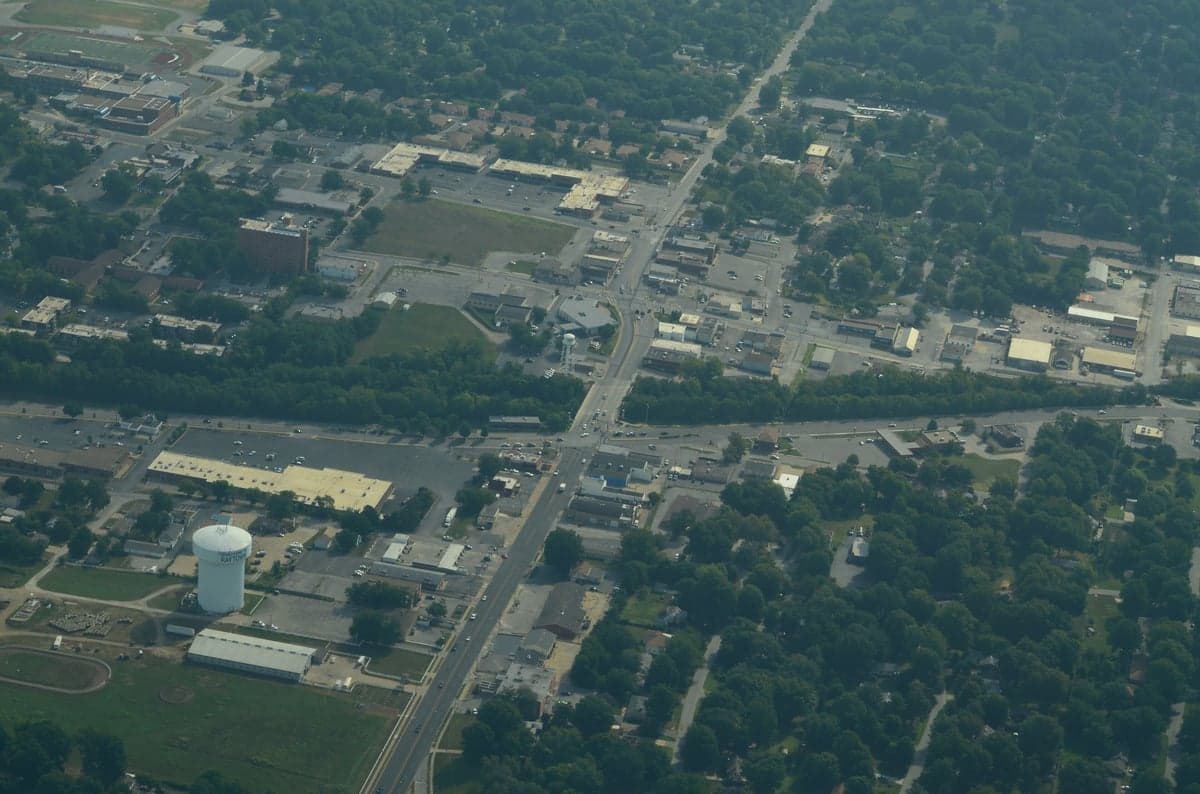
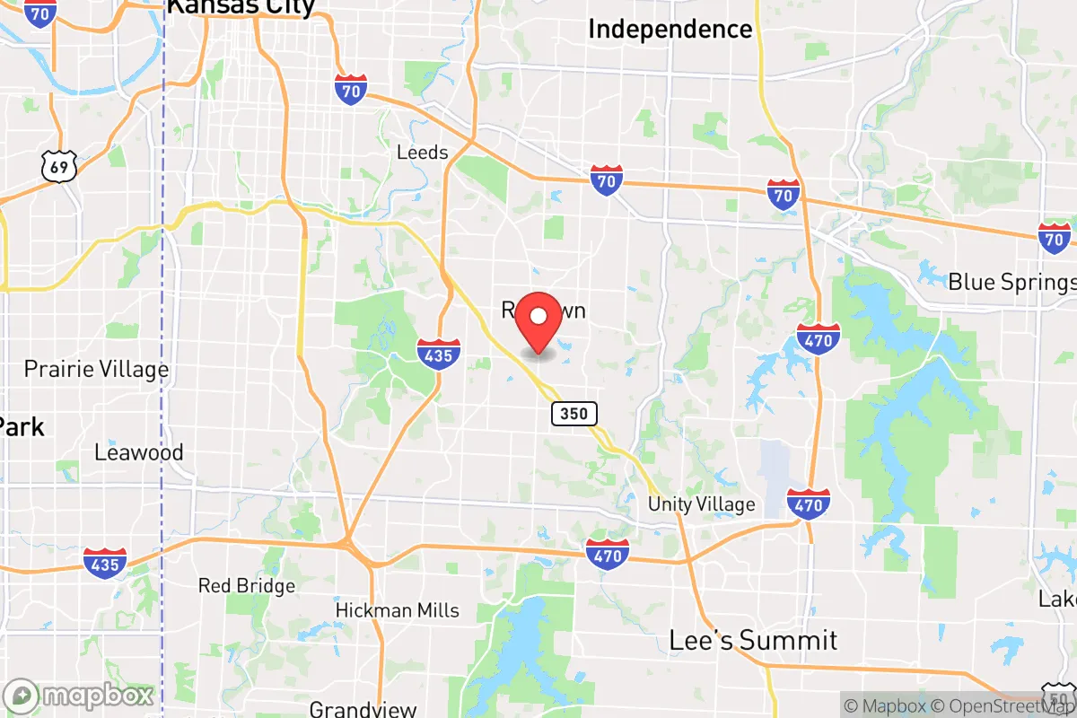
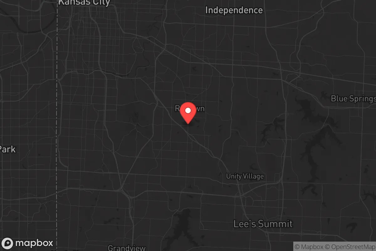
Raytown, Missouri, sits in a precarious but potentially workable position for the conservative prepper or survivalist. Its location on the eastern edge of Jackson County, hard against the Kansas City metro, offers a mix of suburban convenience and a surprisingly resilient geographic posture. While you won't find mountain redoubts or desert isolation here, Raytown’s position on the Missouri River bluffs, its access to multiple interstate corridors, and its status as a secondary population center within a larger metro create a strategic buffer—if you know how to use it. The key is understanding that this is not a bug-out destination; it’s a place to hold ground and leverage proximity to resources while the chaos unfolds elsewhere.
Geographic position and natural advantages for long-term stability
Raytown’s physical geography is more defensible than it first appears. The city sits atop the bluffs overlooking the Blue River Valley, providing natural drainage and elevation that reduces flood risk compared to low-lying areas like Kansas City’s West Bottoms. This elevation also offers limited but useful vantage points for observing movement along major arteries like I-435 and US-50. The surrounding landscape is a mix of rolling hills, wooded creek bottoms, and agricultural land, which means you’re not boxed in by dense urban sprawl. To the east and south, Raytown transitions quickly into unincorporated Jackson County and then into Cass and Johnson counties—areas with lower population density, working farms, and a more rural character. This creates a natural egress corridor if you need to move deeper into the Missouri Ozarks or toward the Lake of the Ozarks region, both of which offer better long-term survival prospects. The Missouri River, about 10 miles north, provides a major water source and a potential transportation route, though it also concentrates infrastructure and population along its banks. For a relocator, the key advantage is that Raytown sits on the edge of the metro’s core, not inside it, giving you a head start if the city collapses inward.
Risks, exposures, and proximity to fallout-relevant landmarks
Let’s be blunt: Raytown is within the blast and fallout radius of several high-value targets. Whiteman Air Force Base, home to the B-2 Spirit stealth bomber, is about 50 miles southeast in Knob Noster. That’s a primary nuclear target. The Kansas City metropolitan area itself hosts major transportation hubs, the Federal Reserve Bank of Kansas City, and critical infrastructure like the Truman Road rail yard and the I-35/I-70 interchange. A coordinated attack or a major EMP event would cripple the region. Raytown’s proximity to these targets—roughly 10-15 miles from downtown Kansas City—means you’d face fallout drift from a ground burst, depending on wind direction. The prevailing winds in this region are from the south and southwest, which would push fallout toward the north and northeast, potentially sparing Raytown from the worst of a strike on Whiteman or the city center. But that’s a gamble, not a guarantee. Beyond nuclear threats, the area is vulnerable to civil unrest. Raytown has a significant population density (about 29,000 people in 10 square miles) and a history of socioeconomic stress. The 2020 protests in Kansas City spilled into nearby suburbs, and Raytown saw its share of property damage and looting. In a grid-down scenario, the city’s proximity to major highways makes it a natural funnel for refugees fleeing the urban core. You’d need to secure your perimeter quickly or risk being overrun.
Practical resilience for a relocator: food, water, energy, and defensibility
For the prepper looking to set up shop, Raytown offers a mixed bag. Water is the first concern. The city draws from the Missouri River via the Kansas City Water Services system, which means you’re dependent on a centralized, vulnerable supply. A prolonged power outage or contamination event would cut off municipal water within hours. You’ll need a backup plan: rainwater catchment, a well (if you can find a property with one, which is rare inside city limits), or a reliable source of bottled water storage. The Blue River runs through the area, but it’s heavily polluted from agricultural runoff and urban stormwater—treatable with a high-quality filter, but not a primary source. Food security is more promising. Raytown is surrounded by agricultural land. Within a 20-mile radius, you have access to corn, soybean, and livestock operations. The Raytown Farmers Market operates seasonally, but for a serious prepper, you’d want to establish relationships with local farmers directly. The city’s zoning allows for backyard chickens and small gardens, but larger livestock is restricted. Energy resilience is a weak point. The grid here is aging and prone to outages during storms. Solar is viable—the region gets about 200 sunny days per year—but you’ll need battery storage to handle the cloudy stretches. Natural gas is widely available, but in a prolonged crisis, the pipeline infrastructure is a target. Defensibility is the hardest sell. Raytown is a typical suburban grid of cul-de-sacs and arterial roads. Your best bet is a property on a corner lot with good sightlines, or better yet, a home on the eastern or southern edge where you have a natural buffer of undeveloped land. The city’s police force is understaffed, like most departments, so you can’t rely on them for protection. A neighborhood watch or a mutual assistance pact with like-minded neighbors is essential. The local gun culture is strong—Missouri is a shall-issue state with no permit required for concealed carry—so you won’t stand out for being armed.
The overall strategic picture for Raytown is one of calculated risk. It’s not a survivalist paradise, but it’s a viable base of operations for someone who wants to stay close to the economic opportunities of Kansas City while maintaining a prepper mindset. The key is to treat Raytown as a staging ground, not a final destination. Stockpile supplies, harden your home, and build a network of trusted contacts in the surrounding rural areas. If the SHTF, you’ll have a 24- to 48-hour window to decide whether to hold or bug out to the Ozarks. The city’s location on the edge of the metro gives you that option, but only if you’re prepared to move fast. For the conservative relocator who values community, self-reliance, and a realistic assessment of threats, Raytown offers a middle ground—neither a fortress nor a death trap. It’s a place to dig in, keep your head down, and wait out the storm, provided you’ve done the work beforehand.
* Values derived from national, state, county, city and local statistics and may differ in a specific area. Last updated: 2026-04-24T13:18:21.000Z
Narrative content on this page is AI-generated and may contain mistakes. Verify any details that matter before acting on them.
ReloMaps may earn a commission from affiliate links at no extra cost to you.