Photo: Wikipedia
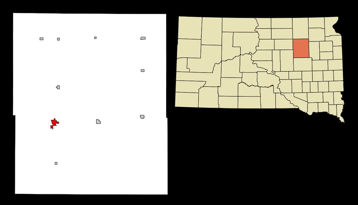
Strategic Assessment of Redfield, SD
Strong survivability profile. Good buffer from population centers, with manageable environmental and tactical risks.
What does the Strategic Assessment tell us?
Our Strategic Assessment grades tactical survivability of an area. Major population centers, military targets, fallout zones, natural disasters, and border exposure all drive risk — lower exposure means a more defensible position in a crisis.
This is heavily inspired by Joel Skousen's Strategic Relocation book. Highly recommended you checkout the book ($)What does this tell us?
Our Strategic Assessment grades tactical survivability of an area. Major population centers, military targets, fallout zones, natural disasters, and border exposure all drive risk — lower exposure means a more defensible position in a crisis.
This is heavily inspired by Joel Skousen's Strategic Relocation book. Highly recommended you checkout the book ($)Strategic Pillars

Key Distances
Regional Safe Places
Below is our recommended "safe zones" in South Dakota and the surrounding area based on our strategic heuristics. For most people, it's unrealistic to live in a “safe zone” full-time due to work, family or other personal reasons. They tend to be more rural. However, many of these areas are perfect for second homes and retreat properties that double as a vacation home or even a short-term rental.


Important Note: For informational purposes only. This does not mean nothing bad ever happens in the green zones. Please use common sense. This is based on public data and modeled with AI. We tried to take a conservative approach but mistakes happen. We update this regularly as new information becomes available.
Solar Generator Recommendations
Backup power matters more here than in safer locations. We've picked three solar generators across budgets and capacity tiers — start with the budget unit if you only need a few essentials, or step up if you want to run a fridge and HVAC for days at a time.

Jackery Portable Power Station Explorer 300
Budget OptionPower on the Go: Weighing only 11 lbs, it's convenient to set up and store with book-sized foldable solar panels

BLUETTI Portable Power Station AC180
Designed for both indoor and outdoor scenarios, AC180 is highly capable as it has a robost capacity and continuous output power.

EF ECOFLOW DELTA Pro Ultra Power Station
Upgraded PickEcoFlow DELTA Pro Ultra is a whole-home energy system designed to grow with your family. Integrated with the Smart Home Panel 2, it scales to meet your evolving energy needs — keeping your home powered, intelligent, and secure through every stage of life.
We earn a commission, at no additional cost to you.
Strategic Assessment Analysis
Redfield, South Dakota, offers a strategic combination of geographic isolation, agricultural self-sufficiency, and low population density that makes it a compelling option for those prioritizing long-term resilience and preparedness. Located in Spink County, roughly 90 miles northeast of Sioux Falls and 50 miles west of Watertown, this town of roughly 2,300 people sits in the heart of the James River Valley, a region defined by flat, fertile farmland and a sparse, widely dispersed population. For a relocator with a survivalist or prepper mindset, Redfield’s primary advantage is its distance from major metropolitan centers and high-value targets, while still maintaining access to essential infrastructure and supply routes. The area’s resilience is rooted in its agricultural base, low crime rates, and a community culture that still values self-reliance and neighborly cooperation—traits that are increasingly rare in more urbanized parts of the country.
Geographic position and natural advantages for long-term survival
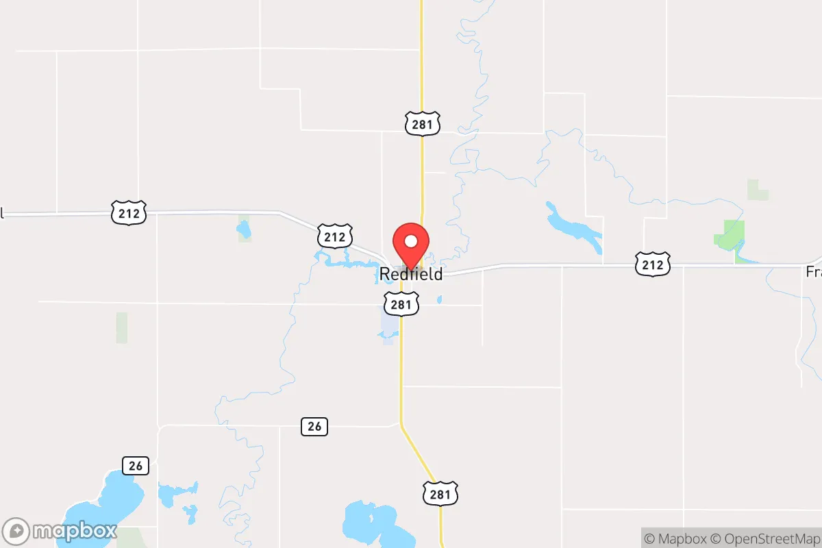
Redfield’s location in east-central South Dakota places it in a zone that is far enough from the major population corridors of the Upper Midwest to reduce exposure to cascading failures from urban unrest or infrastructure collapse. The nearest city of any significant size is Aberdeen, about 40 miles to the north, while Sioux Falls—the state’s largest metro area—is a solid 90-minute drive southeast. This buffer is critical: in the event of widespread civil unrest, supply chain disruptions, or a mass casualty event, Redfield’s isolation means it is unlikely to be a primary target or a destination for fleeing urban populations. The James River runs through the town, providing a surface water source that, while not pristine, can be treated for emergency use. The surrounding landscape is predominantly agricultural, with thousands of acres of corn, soybeans, and wheat within a 20-mile radius. This means that, even in a worst-case scenario, local food production capacity is substantial. The region’s flat terrain also offers clear sightlines and limited natural cover, which is a double-edged sword: it makes the area defensible from a distance but also offers little concealment. Winters are harsh, with average January highs around 20°F and frequent snow, which serves as a natural barrier to movement and a test of preparedness for anyone not accustomed to cold-weather survival.
Risks, exposures, and proximity to fallout-relevant landmarks
While Redfield’s isolation is a strength, it is not without vulnerabilities. The town is located roughly 100 miles from the Ellsworth Air Force Base near Rapid City, which houses B-1B Lancer bombers and is a potential target in a major conflict. However, prevailing winds in the region generally blow from west to east, meaning that fallout from a strike on Ellsworth would likely travel toward the Missouri River and central South Dakota, not directly toward Redfield. More concerning is the proximity to the Minuteman III missile silos scattered across western South Dakota and North Dakota. While Redfield is east of the main silo fields, any large-scale nuclear exchange would likely involve multiple warheads targeting these sites, and the fallout patterns are unpredictable. The town itself has no major industrial or military infrastructure that would make it a primary target, which is a significant advantage. Natural disaster risks are moderate: tornadoes are possible, but the area is not in the heart of Tornado Alley, and blizzards are the more common threat. Flooding along the James River can occur during spring snowmelt, but the town’s elevation and drainage systems mitigate the worst effects. For a relocator, the key takeaway is that Redfield’s risk profile is dominated by regional fallout scenarios rather than direct targeting, and the town’s low population density means that disease spread and resource competition would be less severe than in denser areas.
Practical resilience for a relocator: food, water, energy, and defensibility
For someone serious about self-sufficiency, Redfield offers a realistic foundation. The town’s water supply comes from the James River and groundwater wells, and the municipal system is reliable, but a prepper should plan for private well installation or rainwater catchment as a backup. The agricultural abundance means that local food sources are plentiful: farmers’ markets, direct-from-farm purchases, and the ability to grow your own garden are all viable. The area’s growing season is short (roughly 130 frost-free days), but cold-hardy crops like potatoes, carrots, and kale do well, and livestock raising is common. Energy resilience is a mixed bag: the grid is served by Northwestern Energy and local cooperatives, but winter storms can cause outages. Solar panels are a practical investment, as the region gets about 200 sunny days per year, though snow cover can reduce winter output. Wood heating is common in rural homes, and the surrounding farmland provides ample biomass for fuel. Defensibility is a function of the town’s layout: Redfield is compact, with a few main roads leading in and out, and the flat terrain means that any approaching group would be visible from a distance. The local sheriff’s office and a small police department provide law enforcement, but in a collapse scenario, community organization would be key. The town’s population is predominantly older and conservative, which aligns with a culture of firearm ownership and preparedness—roughly 60% of households in Spink County are estimated to own at least one firearm, according to state-level data. This is a double-edged sword: it means a higher baseline of defensive capability, but also a potential for conflict if resources become scarce.
The overall strategic picture for Redfield is one of moderate-to-high resilience for a relocator willing to invest in preparation. It is not a bug-out location for the unprepared—the harsh winters and remote location require a serious commitment to stockpiling, skills training, and community integration. But for someone who values distance from urban chaos, access to agricultural resources, and a like-minded population, Redfield is a solid choice. The town’s biggest weakness is its reliance on regional infrastructure: the nearest major hospital is in Aberdeen, and specialized medical care requires a drive to Sioux Falls or even Fargo. In a prolonged crisis, this could be a liability. However, for the individual or family focused on long-term survival rather than immediate convenience, Redfield’s combination of isolation, food security, and cultural alignment with self-reliance makes it a location worth serious consideration. The key is to arrive with a plan, not just a hope—and to understand that the same isolation that protects you also demands that you be your own first responder, farmer, and mechanic.
* Values derived from national, state, county, city and local statistics and may differ in a specific area. Last updated: 2026-04-19T06:54:07.000Z
Narrative content on this page is AI-generated and may contain mistakes. Verify any details that matter before acting on them.
ReloMaps may earn a commission from affiliate links at no extra cost to you.