Photo: Wikipedia
Strategic Assessment of Republic, MO
Workable tactical position. Some exposure to population density or targets, but generally defensible in a crisis.
What does the Strategic Assessment tell us?
Our Strategic Assessment grades tactical survivability of an area. Major population centers, military targets, fallout zones, natural disasters, and border exposure all drive risk — lower exposure means a more defensible position in a crisis.
This is heavily inspired by Joel Skousen's Strategic Relocation book. Highly recommended you checkout the book ($)What does this tell us?
Our Strategic Assessment grades tactical survivability of an area. Major population centers, military targets, fallout zones, natural disasters, and border exposure all drive risk — lower exposure means a more defensible position in a crisis.
This is heavily inspired by Joel Skousen's Strategic Relocation book. Highly recommended you checkout the book ($)Strategic Pillars

Key Distances
Regional Safe Places
Below is our recommended "safe zones" in Missouri and the surrounding area based on our strategic heuristics. For most people, it's unrealistic to live in a “safe zone” full-time due to work, family or other personal reasons. They tend to be more rural. However, many of these areas are perfect for second homes and retreat properties that double as a vacation home or even a short-term rental.


Important Note: For informational purposes only. This does not mean nothing bad ever happens in the green zones. Please use common sense. This is based on public data and modeled with AI. We tried to take a conservative approach but mistakes happen. We update this regularly as new information becomes available.
Solar Generator Recommendations
Backup power matters more here than in safer locations. We've picked three solar generators across budgets and capacity tiers — start with the budget unit if you only need a few essentials, or step up if you want to run a fridge and HVAC for days at a time.

Jackery Portable Power Station Explorer 300
Budget OptionPower on the Go: Weighing only 11 lbs, it's convenient to set up and store with book-sized foldable solar panels

BLUETTI Portable Power Station AC180
Designed for both indoor and outdoor scenarios, AC180 is highly capable as it has a robost capacity and continuous output power.

EF ECOFLOW DELTA Pro Ultra Power Station
Upgraded PickEcoFlow DELTA Pro Ultra is a whole-home energy system designed to grow with your family. Integrated with the Smart Home Panel 2, it scales to meet your evolving energy needs — keeping your home powered, intelligent, and secure through every stage of life.
We earn a commission, at no additional cost to you.
Strategic Assessment Analysis
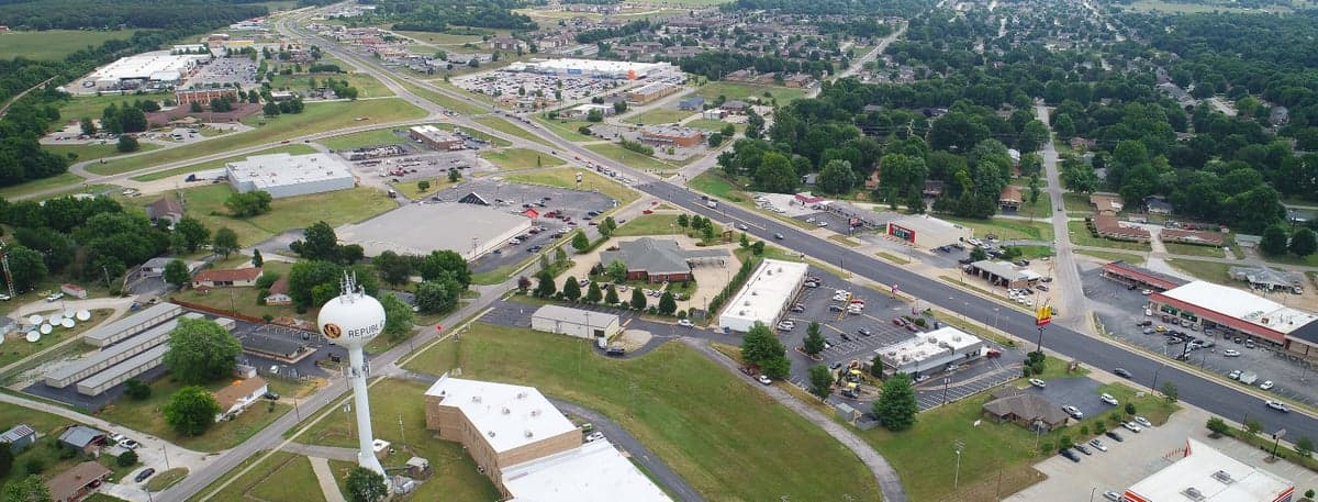
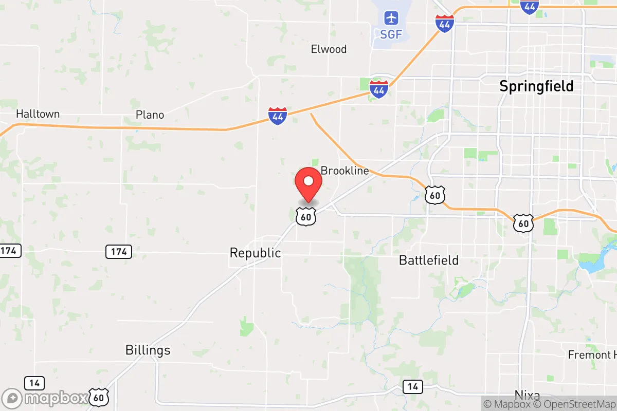
Republic, Missouri, sits in a sweet spot that few preppers fully appreciate: close enough to Springfield for supply runs and medical access, yet far enough to avoid the worst of a city’s collapse dynamics. With a population hovering around 20,000 and steady growth, this southwest Missouri town offers a blend of rural buffer and small-town infrastructure that makes it a viable base for long-term resilience. Its position along the James River and near the Ozark Plateau gives it natural advantages in water access and defensible terrain, while its distance from major interstate corridors reduces the risk of being caught in mass evacuation chokepoints. For a relocator thinking about civic unrest, supply chain disruptions, or even larger-scale disasters, Republic deserves a hard look—but only with eyes open to its specific vulnerabilities.
Geographic position and natural advantages for long-term survival
Republic sits in Greene County, roughly 12 miles southwest of Springfield, placing it on the fringe of the metro area’s suburban sprawl. This proximity is a double-edged sword, but for preppers, the key advantage is that Republic is not on I-44 or I-49—the two major highways that would become evacuation and refugee corridors in a crisis. Instead, it’s accessed via US-60 and MO-413, secondary roads that are easier to monitor and, if necessary, control. The surrounding terrain is rolling hills with mixed hardwood forest and limestone bluffs, offering natural cover and multiple defensible positions. The James River runs just east of town, providing a reliable surface water source that, with proper filtration, can sustain a household indefinitely. The area’s karst topography also means numerous springs and underground aquifers, though well drilling is recommended for any serious off-grid setup. The climate is temperate four-season, with hot summers and cold winters, but the region rarely sees the extreme weather events that plague the coasts or tornado alley’s core. That said, Greene County is in a moderate risk zone for tornadoes—so a storm shelter is non-negotiable for any prepared property.
Risks, exposures, and proximity to fallout-relevant landmarks
The biggest strategic downside to Republic is its proximity to Springfield, a city of roughly 170,000 that would become a focal point for unrest, resource competition, and potential FEMA staging in a national emergency. In a mass casualty event or civil unrest scenario, Springfield’s population would likely push outward along US-60, directly toward Republic. The town’s position as a bedroom community means many residents already commute to Springfield for work, creating a daily flow that could turn into a one-way flood of people if the city collapses. Additionally, Republic is within 50 miles of the Buffalo National River area and the Mark Twain National Forest, which are attractive bug-out zones but also likely to be heavily trafficked by others with the same idea. There are no nuclear power plants within immediate fallout range—the closest is the Arkansas Nuclear One near Russellville, about 150 miles south—but the region’s prevailing winds from the west-southwest mean any major incident at that facility would put Republic in a moderate fallout plume zone. More immediate risks include the rail lines running through Springfield, which carry hazardous materials, and the presence of a large regional medical center (Mercy Hospital Springfield) that could become a target or overwhelmed facility during a pandemic or mass casualty event. For the prepper, the takeaway is that Republic’s buffer is real but thin—you need a plan for the first 72 hours when Springfield’s population starts moving.
Practical resilience for a relocator: food, water, energy, and defensibility
For someone looking to establish a resilient homestead, Republic offers solid fundamentals. The soil in the surrounding area is primarily clay-loam, suitable for gardening with raised beds or amendments, and the growing season runs roughly April through October—long enough for two crop cycles of staples like beans, squash, and corn. Local farmers’ markets and co-ops exist but are small; serious preppers should plan to establish their own food production within the first year. Water is the stronger suit: the James River is perennial and accessible from multiple public access points, but owning property with a creek or well is far better. The Ozark aquifer system is deep but reliable, and many rural properties in the county already have private wells. Electricity comes from City Utilities of Springfield and local co-ops, but the grid here is not hardened against ice storms or high winds—power outages lasting 3–7 days are common in winter. Solar is viable, with the region averaging about 200 sunny days per year, but battery storage is essential given the frequent cloud cover. Defensibility is mixed: Republic itself is a typical small town with open grid streets, but the rural fringe offers properties with long driveways, tree lines, and natural elevation changes that create good fields of fire and observation. The local sheriff’s office is responsive but small—about 40 deputies for the entire county—so in a prolonged crisis, you are largely on your own. The community itself is predominantly conservative, with a strong church presence and a culture of mutual aid among like-minded residents, which can be a force multiplier if you integrate early.
Overall, Republic, Missouri, presents a credible option for the strategic relocator who wants to be near enough to civilization to maintain a normal life but far enough to have a fighting chance when things go sideways. Its natural water access, moderate climate, and rural buffer are genuine assets, while its proximity to Springfield and the lack of hardened infrastructure are the main liabilities. The key is to treat Republic not as a final bug-out location but as a base of operations—a place to build relationships, cache supplies, and develop a network before the storm hits. If you’re willing to invest in a well, solar, and a storm shelter, and you can secure property on the outskirts rather than in town, this area offers a realistic balance of everyday livability and crisis preparedness. Just don’t expect to be invisible—every prepper in the Midwest has their eye on the Ozarks, and Republic is no secret. The advantage goes to those who arrive early, dig in deep, and keep their plans quiet.
* Values derived from national, state, county, city and local statistics and may differ in a specific area. Last updated: 2026-04-30T04:10:49.000Z
Narrative content on this page is AI-generated and may contain mistakes. Verify any details that matter before acting on them.
ReloMaps may earn a commission from affiliate links at no extra cost to you.