

Photo: Wikipedia
Strategic Assessment of Scarsdale, NY
High tactical risk. This location is likely close to major population centers, strategic targets, or sits in a high-disaster corridor. A retreat property and careful exit planning is required.
What does the Strategic Assessment tell us?
Our Strategic Assessment grades tactical survivability of an area. Major population centers, military targets, fallout zones, natural disasters, and border exposure all drive risk — lower exposure means a more defensible position in a crisis.
This is heavily inspired by Joel Skousen's Strategic Relocation book. Highly recommended you checkout the book ($)What does this tell us?
Our Strategic Assessment grades tactical survivability of an area. Major population centers, military targets, fallout zones, natural disasters, and border exposure all drive risk — lower exposure means a more defensible position in a crisis.
This is heavily inspired by Joel Skousen's Strategic Relocation book. Highly recommended you checkout the book ($)Strategic Pillars

Key Distances
Regional Safe Places
Below is our recommended "safe zones" in New York and the surrounding area based on our strategic heuristics. For most people, it's unrealistic to live in a “safe zone” full-time due to work, family or other personal reasons. They tend to be more rural. However, many of these areas are perfect for second homes and retreat properties that double as a vacation home or even a short-term rental.


Important Note: For informational purposes only. This does not mean nothing bad ever happens in the green zones. Please use common sense. This is based on public data and modeled with AI. We tried to take a conservative approach but mistakes happen. We update this regularly as new information becomes available.
Solar Generator Recommendations
Backup power matters more here than in safer locations. We've picked three solar generators across budgets and capacity tiers — start with the budget unit if you only need a few essentials, or step up if you want to run a fridge and HVAC for days at a time.

Jackery Portable Power Station Explorer 300
Budget OptionPower on the Go: Weighing only 11 lbs, it's convenient to set up and store with book-sized foldable solar panels

BLUETTI Portable Power Station AC180
Designed for both indoor and outdoor scenarios, AC180 is highly capable as it has a robost capacity and continuous output power.

EF ECOFLOW DELTA Pro Ultra Power Station
Upgraded PickEcoFlow DELTA Pro Ultra is a whole-home energy system designed to grow with your family. Integrated with the Smart Home Panel 2, it scales to meet your evolving energy needs — keeping your home powered, intelligent, and secure through every stage of life.
We earn a commission, at no additional cost to you.
Strategic Assessment Analysis
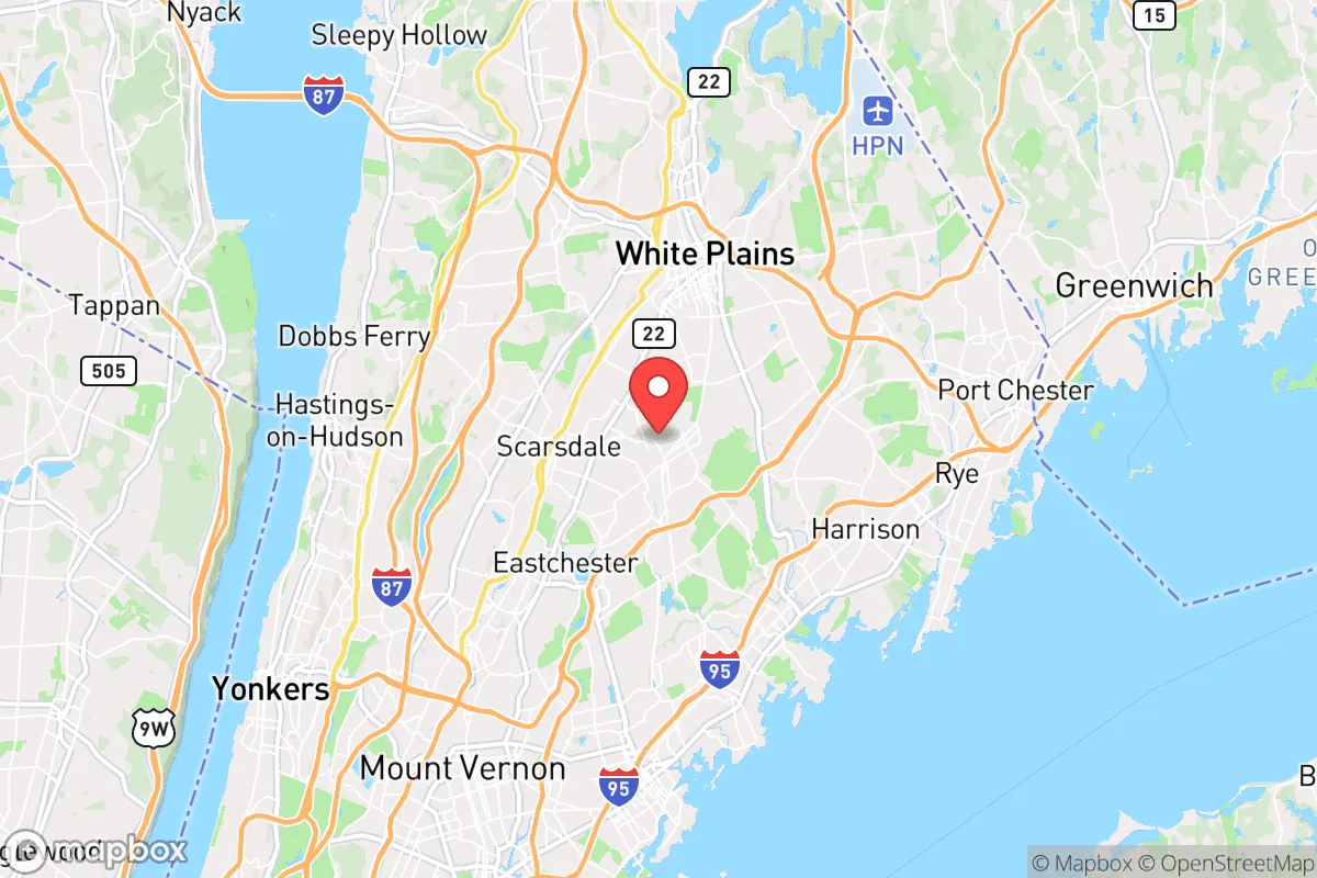
Scarsdale, New York, presents a complex strategic picture for the conservative prepper or survivalist. Its primary advantage is its position as a high-value, low-visibility asset: a wealthy, well-managed suburb with deep community ties and significant local resources, yet it sits just 25 miles north of Manhattan. This proximity to a major population and geopolitical target is the central tension of any resilience assessment here. The town’s genuine strengths in social cohesion, local governance, and physical infrastructure are real, but they are inextricably linked to the risks of being within the blast and fallout radius of New York City, a top-tier target in any major conflict or mass casualty event. For the relocator seeking true strategic depth, Scarsdale offers a high baseline of comfort and preparedness, but not true isolation.
Geographic position, natural buffers, and strategic depth
Scarsdale occupies a defensible pocket of Westchester County, roughly 4.8 square miles of hilly, wooded terrain. It is not coastal, sitting about 10 miles inland from Long Island Sound, which removes the direct storm surge risk but not the broader hurricane or nor’easter impacts. The area is part of the Bronx River watershed, with the Bronx River itself forming a natural eastern boundary. This river, along with the Hutchinson River Parkway and the Cross County Parkway, creates a series of chokepoints and natural barriers that could slow or channel movement in a crisis. The town’s elevation ranges from roughly 100 to 300 feet above sea level, offering decent vantage points but no commanding high ground. The surrounding landscape is dense suburban development, not wilderness. The nearest true wilderness corridor is the 4,700-acre Ward Pound Ridge Reservation, about 12 miles north, which is a viable but not immediate bug-out location. The strategic depth here is shallow: you are 30 minutes from a major city by car, but in a gridlock scenario, that becomes hours. The natural advantages are modest—some tree cover, some water features—but the real asset is the town’s internal layout: winding roads, cul-de-sacs, and a lack of major through-arteries within the village itself, which makes it harder for large, disorganized groups to penetrate quickly.
Risks, exposures, and proximity to fallout-relevant landmarks
The single greatest risk for Scarsdale is its proximity to New York City, a primary target for any nuclear or large-scale conventional attack. The distance to Midtown Manhattan is roughly 22 miles as the crow flies. In a nuclear detonation scenario, Scarsdale would likely be outside the immediate blast and thermal damage zone for a single warhead, but it would be squarely in the moderate-to-heavy fallout plume path depending on wind direction. The prevailing winds are from the west and northwest, meaning fallout from a NYC strike would likely blow east over Long Island and the Atlantic, but a shift to southerly winds would push contamination directly over Westchester. The Indian Point Energy Center, a now-decommissioned nuclear plant, sits about 15 miles south-southwest in Buchanan, NY. While decommissioned, spent fuel remains on site in dry cask storage, a potential target or accident risk. Other nearby critical infrastructure includes the Tappan Zee Bridge (now Governor Mario M. Cuomo Bridge), a major chokepoint 8 miles west, and the I-95 corridor, a primary evacuation route that would be instantly gridlocked. The area is also within the flight path of Westchester County Airport (HPN), a general aviation and corporate jet hub 5 miles northeast, which could be a target or a source of chaos during an evacuation. For the prepper, the exposure is not just physical but logistical: Scarsdale’s population of roughly 18,000 would be joined by hundreds of thousands of evacuees from the city, overwhelming local roads, supplies, and security. The town’s wealth makes it a likely target for looting and refugee pressure in a prolonged crisis.
Practical resilience for a relocator: food, water, energy, and defensibility
Scarsdale’s practical resilience is a mixed bag. The town is served by the New York City water supply system, specifically the Catskill/Delaware watersheds, via the Kensico Reservoir, located about 10 miles north. This is a high-quality, gravity-fed system, but it is a single point of failure: a major earthquake or sabotage at the reservoir or the aqueducts would cut supply. Private wells are rare in the village core, so most residents are entirely dependent on municipal water. For food, Scarsdale has no significant agricultural land within its borders. The nearest working farms are in northern Westchester and Putnam counties, 20+ miles away. The town does have several high-end grocery stores (e.g., DeCicco & Sons, Whole Foods) that would be stripped within hours of a crisis. Long-term food storage is a must, not an option. Energy is more promising: the area is served by Con Edison, with a relatively robust grid, but underground power lines are common in the older, wealthier sections, reducing storm-related outages. Natural gas is widely available for heating and cooking. Solar potential is moderate—the tree cover limits rooftop yield, but a ground-mounted system on a larger property is feasible. Defensibility is the weakest link. Scarsdale is a classic suburban grid of interconnected streets. There are no natural defensive positions, no walls, no gates. The town’s police force is professional and well-funded (about 40 sworn officers), but they are not equipped for sustained civil defense. The best defensive strategy is low profile: a well-stocked home on a quiet cul-de-sac, with good relationships with neighbors, and a pre-planned bug-out route to a more rural location. The town’s strong homeowners’ associations and community networks are a double-edged sword—they foster cooperation but also create a visible target for outsiders.
The overall strategic picture for Scarsdale is one of high baseline comfort but low strategic depth. It is an excellent location for a prepper who values community, local governance, and immediate access to high-quality services, but who is willing to accept the risks of being within the shadow of a major target. For the single individual or family seeking true resilience against civil unrest, mass casualty events, or societal collapse, Scarsdale is a staging ground, not a final redoubt. The smart play here is to use the town’s resources—its excellent schools, its professional networks, its financial infrastructure—to build the capital and connections needed to secure a more remote property elsewhere. As a primary residence, it offers a comfortable, low-crime environment with a like-minded conservative community, but the moment the crisis escalates beyond a localized event, the plan must be to leave. The town’s greatest strength—its proximity to New York—is also its greatest vulnerability. For the strategic relocator, Scarsdale is a base of operations, not a fortress.
* Values derived from national, state, county, city and local statistics and may differ in a specific area. Last updated: 2026-04-23T02:50:47.000Z
Narrative content on this page is AI-generated and may contain mistakes. Verify any details that matter before acting on them.
ReloMaps may earn a commission from affiliate links at no extra cost to you.