Photo: Wikipedia
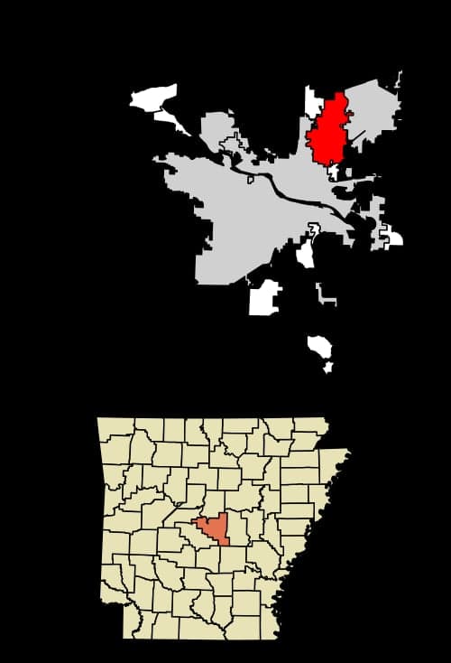
Strategic Assessment of Sherwood, AR
Workable tactical position. Some exposure to population density or targets, but generally defensible in a crisis.
What does the Strategic Assessment tell us?
Our Strategic Assessment grades tactical survivability of an area. Major population centers, military targets, fallout zones, natural disasters, and border exposure all drive risk — lower exposure means a more defensible position in a crisis.
This is heavily inspired by Joel Skousen's Strategic Relocation book. Highly recommended you checkout the book ($)What does this tell us?
Our Strategic Assessment grades tactical survivability of an area. Major population centers, military targets, fallout zones, natural disasters, and border exposure all drive risk — lower exposure means a more defensible position in a crisis.
This is heavily inspired by Joel Skousen's Strategic Relocation book. Highly recommended you checkout the book ($)Strategic Pillars

Key Distances
Regional Safe Places
Below is our recommended "safe zones" in Arkansas and the surrounding area based on our strategic heuristics. For most people, it's unrealistic to live in a “safe zone” full-time due to work, family or other personal reasons. They tend to be more rural. However, many of these areas are perfect for second homes and retreat properties that double as a vacation home or even a short-term rental.


Important Note: For informational purposes only. This does not mean nothing bad ever happens in the green zones. Please use common sense. This is based on public data and modeled with AI. We tried to take a conservative approach but mistakes happen. We update this regularly as new information becomes available.
Solar Generator Recommendations
Backup power matters more here than in safer locations. We've picked three solar generators across budgets and capacity tiers — start with the budget unit if you only need a few essentials, or step up if you want to run a fridge and HVAC for days at a time.

Jackery Portable Power Station Explorer 300
Budget OptionPower on the Go: Weighing only 11 lbs, it's convenient to set up and store with book-sized foldable solar panels

BLUETTI Portable Power Station AC180
Designed for both indoor and outdoor scenarios, AC180 is highly capable as it has a robost capacity and continuous output power.

EF ECOFLOW DELTA Pro Ultra Power Station
Upgraded PickEcoFlow DELTA Pro Ultra is a whole-home energy system designed to grow with your family. Integrated with the Smart Home Panel 2, it scales to meet your evolving energy needs — keeping your home powered, intelligent, and secure through every stage of life.
We earn a commission, at no additional cost to you.
Strategic Assessment Analysis
Sherwood, Arkansas, sits in a position that demands a hard, clear-eyed look from anyone serious about long-term preparedness. It’s not a remote bunker in the mountains, but it’s also not a sprawling, chaotic metro. Its real strategic value lies in a specific kind of resilience: the ability to leverage proximity to critical infrastructure and supply lines while maintaining enough distance from the most obvious target zones. For a relocator thinking in terms of decades, not just next year, Sherwood offers a calculated middle ground—close enough to resources to be practical, far enough from the worst fallout to buy you time.
Geographic position and natural advantages for long-term security
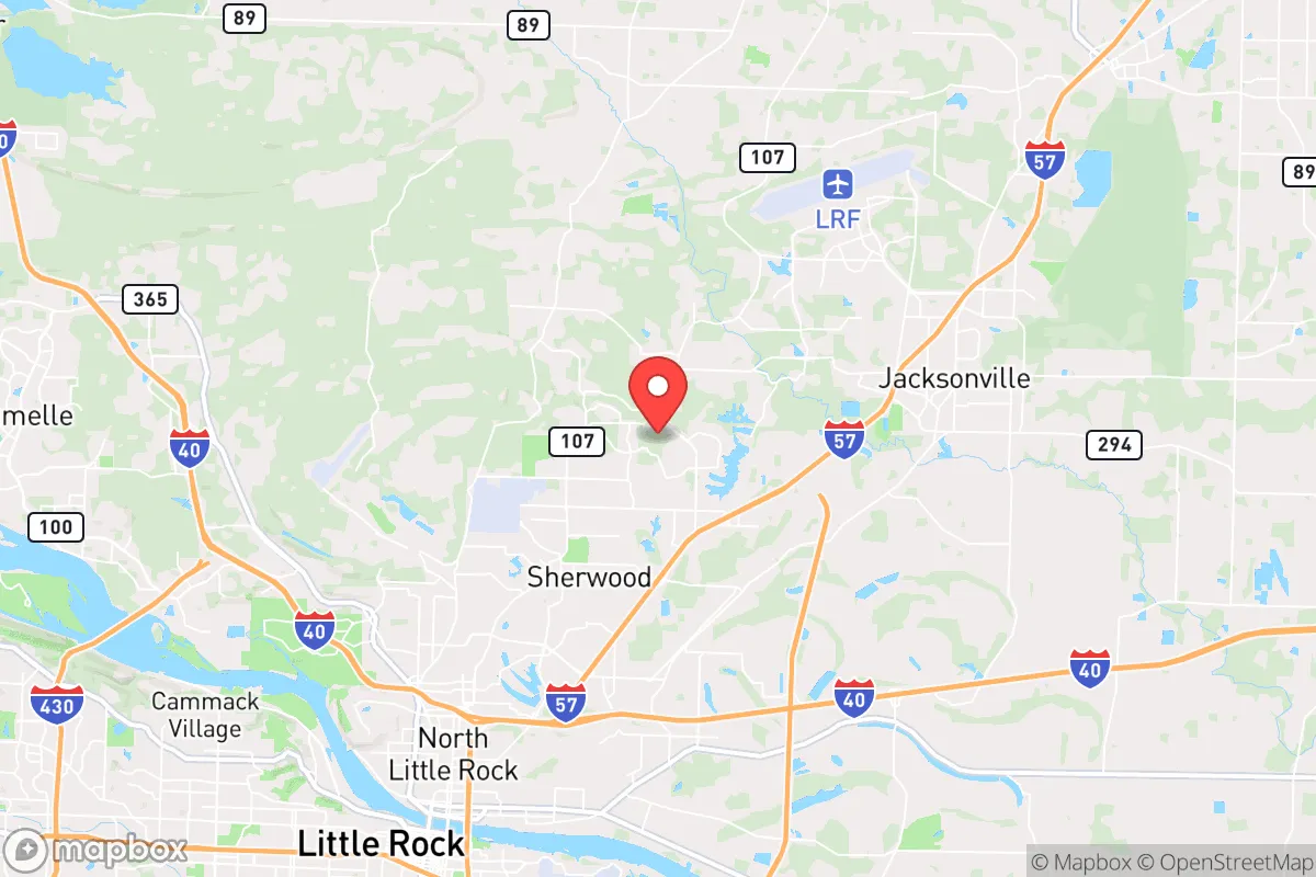
Sherwood’s location in central Arkansas, just north of the Arkansas River and roughly 15 miles northeast of downtown Little Rock, gives it a layered geographic profile. The area sits on the edge of the Arkansas Delta and the foothills of the Ouachita Mountains, meaning you get a mix of flat, arable land and rolling, wooded terrain. That’s not trivial. The Arkansas River Valley provides a reliable water source and a natural corridor for movement, but the surrounding hills offer defensible positions and cover. The climate is humid subtropical—hot summers, mild winters—which supports year-round gardening and livestock, a critical factor if supply chains falter. Annual rainfall averages around 50 inches, so water catchment is viable, and the growing season stretches from March to November. For a prepper, that’s a 9-month window to produce food, not a 3-month gamble. The area is also outside the major hurricane strike zones of the Gulf Coast and the tornado alley bullseye of Oklahoma, though severe weather is still a factor. The natural advantage here is redundancy: multiple water sources, long growing seasons, and terrain that breaks up line-of-sight for anyone approaching.
Risks, exposures, and proximity to fallout-relevant landmarks
This is where the analysis gets uncomfortable, and you need to hear it straight. Sherwood’s biggest vulnerability is its proximity to Little Rock, a city of roughly 200,000 people and a regional hub for government, healthcare, and logistics. In a major civil unrest scenario or a mass casualty event, Little Rock becomes a magnet for chaos—looting, refugee flows, and potential targeting of infrastructure like the Clinton National Airport, the Port of Little Rock, and the I-30/I-40 interchange. The Arkansas Nuclear One plant in Russellville, about 75 miles northwest, is a non-trivial concern. While that distance is outside the immediate blast zone, prevailing winds from the south and southwest could carry fallout across central Arkansas depending on the season. The Little Rock Air Force Base in Jacksonville, just 10 miles east of Sherwood, is a double-edged sword. It’s a strategic asset that could be a target in a conflict, but it also means a military presence that could provide security or become a focal point for unrest. The rail lines and interstate corridors running through Sherwood (I-40, I-440, Union Pacific tracks) are critical for national supply chains, which makes them potential choke points or targets. In a grid-down scenario, those same routes become vectors for displaced populations moving out of the city. The risk profile is moderate, not extreme, but it’s real. You’re not in a blast zone, but you’re in the shadow of one.
Practical resilience for a relocator: food, water, energy, and defensibility
Let’s get tactical. Sherwood is a suburb, not a wilderness, so your resilience plan has to account for that. Water is the first concern. The city draws from the Central Arkansas Water system, which pulls from Lake Maumelle and the Arkansas River. That’s a centralized target. A well on your property is the gold standard here, and the water table in Pulaski County is generally accessible at 50-150 feet. If you’re renting or buying in a subdivision, check for shared wells or community water systems—those are single points of failure. Food production is viable. The soil is loamy in many parts, and the long growing season means you can run three cycles of cool-weather crops (kale, carrots, onions) and two of warm-weather (tomatoes, peppers, squash). Backyard chickens are legal within city limits with some restrictions, and larger livestock is possible on the outskirts. The energy picture is mixed. The grid is served by Entergy Arkansas, which has a mix of natural gas, coal, and nuclear. Solar is a solid hedge here—the area gets about 210 sunny days per year, which is average but workable with a battery backup. Natural gas is widely available, and a dual-fuel generator is a smart investment. Defensibility is the weak point. Sherwood is a typical suburban grid—cul-de-sacs, main arteries, and a few choke points like the intersection of Highway 107 and Highway 67/167. In a worst-case scenario, you’re not holding a perimeter. Your strategy has to be low-profile: blend in, stock deep, and have a bug-out route north toward the Ozarks or east toward the Mississippi River bottoms. The Greers Ferry Lake area, about 50 miles north, offers a secondary position with better terrain and water access. The practical takeaway: Sherwood works as a base of operations, not a final redoubt. You can live well here, but you need a plan for the day you can’t.
The overall strategic picture for Sherwood is one of calculated trade-offs. It’s not a survivalist paradise, and it’s not a death trap. It’s a place where a prepared individual or family can build a sustainable life with access to jobs, healthcare, and supply lines, while maintaining enough distance from the worst-case scenarios that would overwhelm a major city. The key is to treat it as a forward operating base—invest in water independence, food production, and a low profile. The conservative perspective here isn’t about hiding from the world; it’s about being ready for when the world comes knocking. Sherwood gives you a fighting chance, but only if you take the work seriously. The rest is just wishful thinking.
* Values derived from national, state, county, city and local statistics and may differ in a specific area. Last updated: 2026-04-30T02:17:22.000Z
Narrative content on this page is AI-generated and may contain mistakes. Verify any details that matter before acting on them.
ReloMaps may earn a commission from affiliate links at no extra cost to you.