Photo: Wikipedia
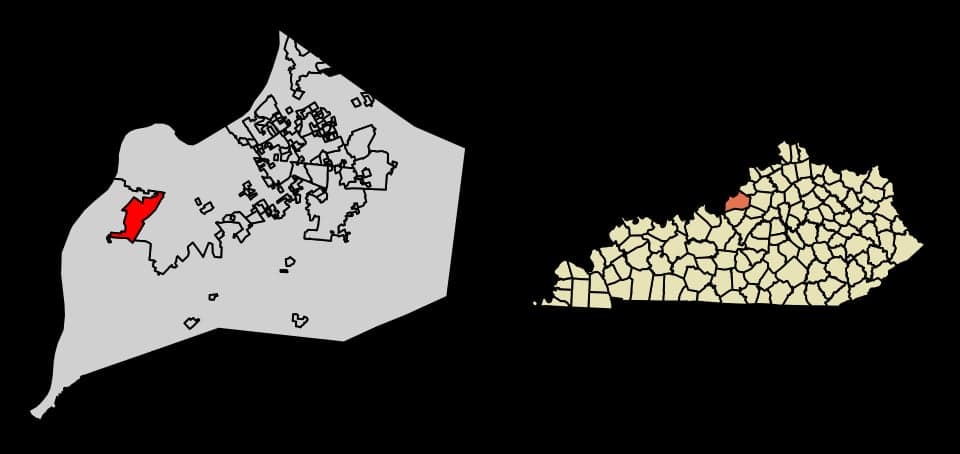
Strategic Assessment of Shively, KY
Multiple tactical vulnerabilities. Population density, target proximity, or disaster risk are likely compounding. A retreat property and exit planning is required.
What does the Strategic Assessment tell us?
Our Strategic Assessment grades tactical survivability of an area. Major population centers, military targets, fallout zones, natural disasters, and border exposure all drive risk — lower exposure means a more defensible position in a crisis.
This is heavily inspired by Joel Skousen's Strategic Relocation book. Highly recommended you checkout the book ($)What does this tell us?
Our Strategic Assessment grades tactical survivability of an area. Major population centers, military targets, fallout zones, natural disasters, and border exposure all drive risk — lower exposure means a more defensible position in a crisis.
This is heavily inspired by Joel Skousen's Strategic Relocation book. Highly recommended you checkout the book ($)Strategic Pillars

Key Distances
Regional Safe Places
Below is our recommended "safe zones" in Kentucky and the surrounding area based on our strategic heuristics. For most people, it's unrealistic to live in a “safe zone” full-time due to work, family or other personal reasons. They tend to be more rural. However, many of these areas are perfect for second homes and retreat properties that double as a vacation home or even a short-term rental.


Important Note: For informational purposes only. This does not mean nothing bad ever happens in the green zones. Please use common sense. This is based on public data and modeled with AI. We tried to take a conservative approach but mistakes happen. We update this regularly as new information becomes available.
Solar Generator Recommendations
Backup power matters more here than in safer locations. We've picked three solar generators across budgets and capacity tiers — start with the budget unit if you only need a few essentials, or step up if you want to run a fridge and HVAC for days at a time.

Jackery Portable Power Station Explorer 300
Budget OptionPower on the Go: Weighing only 11 lbs, it's convenient to set up and store with book-sized foldable solar panels

BLUETTI Portable Power Station AC180
Designed for both indoor and outdoor scenarios, AC180 is highly capable as it has a robost capacity and continuous output power.

EF ECOFLOW DELTA Pro Ultra Power Station
Upgraded PickEcoFlow DELTA Pro Ultra is a whole-home energy system designed to grow with your family. Integrated with the Smart Home Panel 2, it scales to meet your evolving energy needs — keeping your home powered, intelligent, and secure through every stage of life.
We earn a commission, at no additional cost to you.
Strategic Assessment Analysis
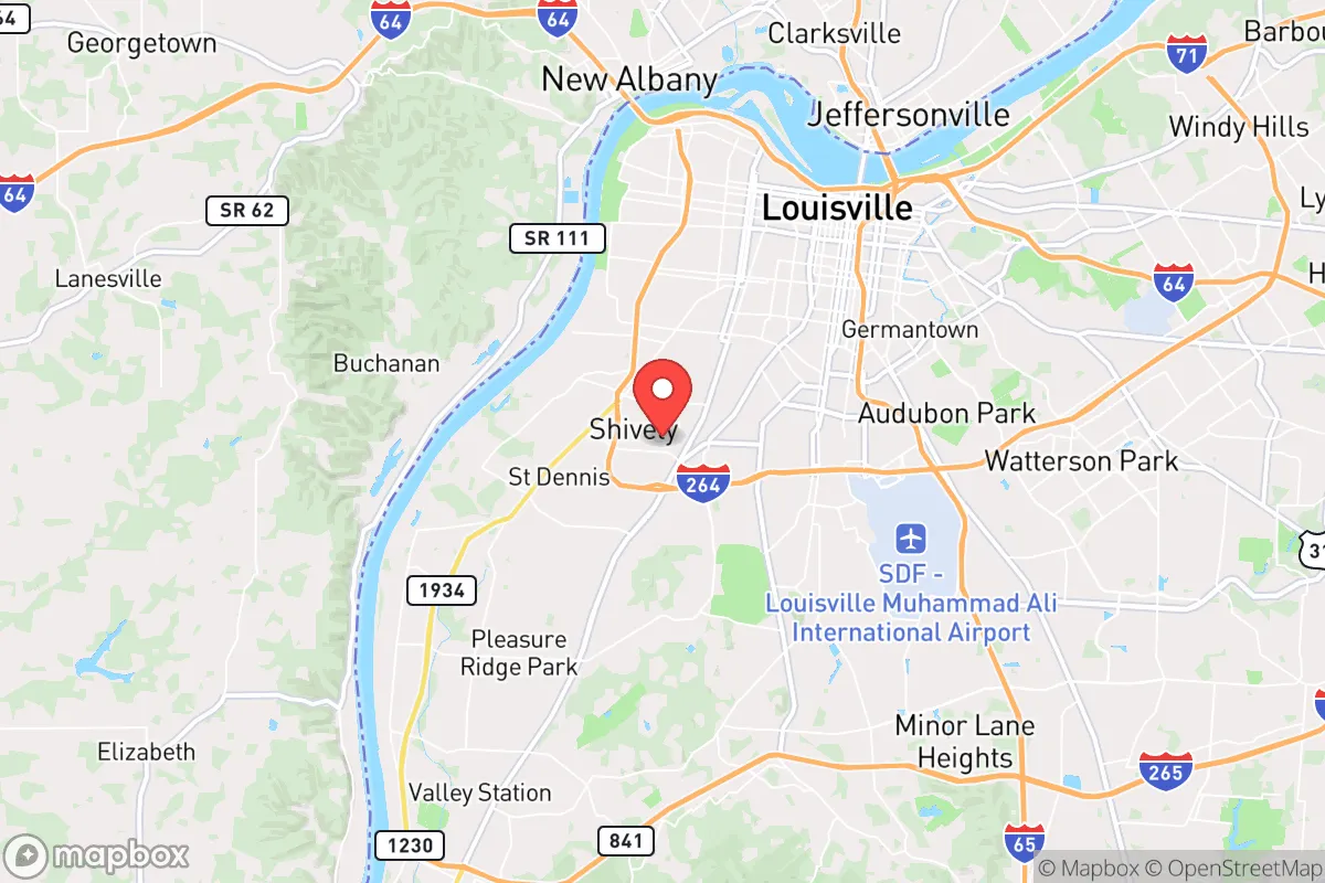
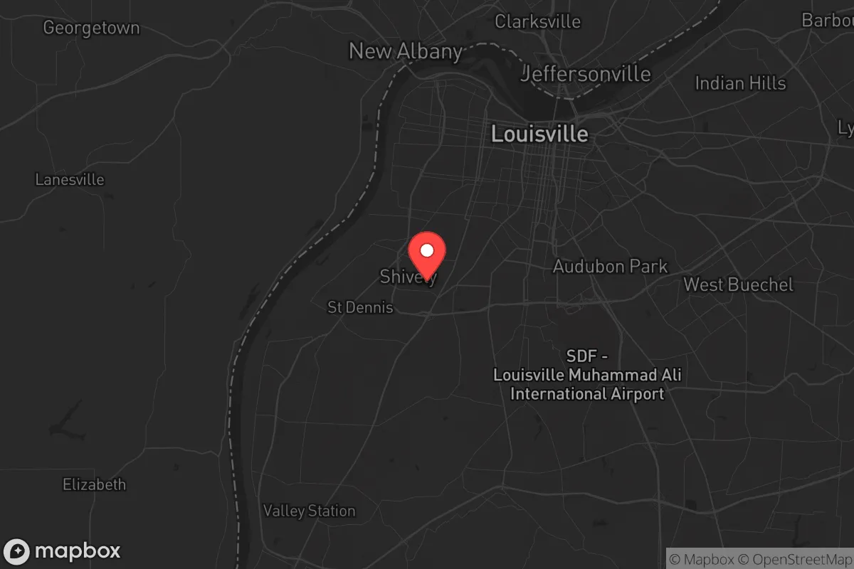
Shively, Kentucky, sits in a precarious strategic position that demands a clear-eyed assessment. While its location within Jefferson County offers immediate access to Louisville’s resources, that same proximity introduces significant vulnerabilities for anyone prioritizing long-term resilience and self-sufficiency. For the conservative prepper or survivalist, Shively is best understood as a buffer-zone location—close enough to a major urban center to be affected by its collapse, but with enough local infrastructure to serve as a staging ground if you have a clear exit plan.
Geographic position and natural advantages for a prepper household
Shively’s geography is defined by its position in the Ohio River Valley, roughly 5 miles southwest of downtown Louisville. The area sits on relatively flat, well-drained land, with the Ohio River about 3 miles north. This river is a double-edged sword: it provides a massive water source for filtration and transport, but it also marks a major industrial corridor that could become a target or chokepoint during unrest. The surrounding terrain offers no significant natural barriers—no mountains, no dense forests—which means defensibility is low without deliberate preparation. However, the region’s fertile soil and moderate climate (average 45 inches of rain annually) make it viable for small-scale food production, provided you have the land and know-how. The primary natural advantage here is water availability and a growing season long enough for two crop cycles, but you’ll need to secure your own well or rainwater catchment because municipal supply is vulnerable to disruption.
Risks, exposures, and proximity to fallout-relevant landmarks
The most glaring risk for Shively is its location within the Louisville metropolitan area, a population center of roughly 1.3 million people. In a scenario involving civil unrest, grid collapse, or a mass casualty event, Shively would be caught in the outer ring of urban chaos. The city is directly adjacent to the Louisville International Airport (SDF) and the UPS Worldport hub, one of the busiest cargo airports in the world. That facility is a high-value target for both state and non-state actors, and any disruption there—whether from a cyberattack, EMP, or physical strike—would ripple through Shively within hours. Additionally, the Ohio River corridor hosts multiple chemical plants, refineries, and the Fort Knox military installation (about 35 miles southwest), which could become a focal point for federal response or, conversely, a target. The risk of fallout from a conventional or radiological event is moderate but real: prevailing winds from the west could carry contamination from industrial sites along the river. Shively itself has no major fallout shelters or hardened infrastructure; the local schools and municipal buildings are standard construction. For a relocator, the key takeaway is that Shively is not a retreat—it’s a location that demands constant situational awareness and a pre-planned evacuation route to the south or east, away from the river and the urban core.
Practical resilience for a relocator: food, water, energy, and defensibility
For someone looking to establish a resilient household in Shively, the practical challenges are significant but not insurmountable. Water: The municipal supply comes from the Ohio River via the Louisville Water Company. In a grid-down scenario, this system would fail within days. A private well is the best bet, but many Shively properties are on city water. Rainwater collection is legal in Kentucky, but you’ll need a large cistern and filtration—plan for at least 50 gallons per person per month for basic needs. Food: Local grocery options are limited to standard chains (Kroger, Walmart), which will empty within 48 hours of a crisis. Community gardens and farmers’ markets exist but are small-scale. For serious food security, you’d need to secure land outside the city—Shively’s average lot size is under 0.25 acres, insufficient for meaningful self-sufficiency. Energy: LG&E provides electricity and natural gas. The grid is aging and vulnerable to weather events (ice storms, tornadoes) and cyberattacks. Solar panels with battery storage are viable, but HOAs in some Shively neighborhoods may restrict them. A backup generator running on propane or diesel is more practical, but fuel storage is limited by local fire codes. Defensibility: Shively is a dense, suburban environment with narrow streets and limited sightlines. A single-family home on a corner lot offers the best defensive position, but most properties are exposed. The local police department is small (roughly 30 officers) and would be overwhelmed in a widespread event. Your best bet is to harden your home with reinforced doors, window film, and a secure perimeter—but understand that you’re in a neighborhood, not a compound. Community resilience is possible if you build relationships with like-minded neighbors, but that takes time and trust.
The overall strategic picture for Shively is one of calculated risk. It is not a location for a standalone retreat or a long-term survival homestead. Its value lies in its proximity to Louisville’s resources—medical facilities, hardware stores, and trade networks—while still being far enough out to avoid the worst of an urban collapse in the first 72 hours. For a single individual or a family with a conservative, preparedness-minded outlook, Shively could serve as a temporary base while you scout more defensible property in the surrounding counties (Bullitt, Spencer, or Nelson). The key is to treat it as a stepping stone, not a final destination. If you’re willing to invest in water storage, alternative energy, and a solid evacuation plan, Shively offers a reasonable balance of access and risk. But if you’re looking for a place to ride out a long-term crisis without constant vigilance, look further south, away from the Ohio River corridor and the urban shadow of Louisville.
* Values derived from national, state, county, city and local statistics and may differ in a specific area. Last updated: 2026-04-21T09:49:42.000Z
Narrative content on this page is AI-generated and may contain mistakes. Verify any details that matter before acting on them.
ReloMaps may earn a commission from affiliate links at no extra cost to you.