Photo: Wikipedia
Strategic Assessment of Sisseton, SD
Strong survivability profile. Good buffer from population centers, with manageable environmental and tactical risks.
What does the Strategic Assessment tell us?
Our Strategic Assessment grades tactical survivability of an area. Major population centers, military targets, fallout zones, natural disasters, and border exposure all drive risk — lower exposure means a more defensible position in a crisis.
This is heavily inspired by Joel Skousen's Strategic Relocation book. Highly recommended you checkout the book ($)What does this tell us?
Our Strategic Assessment grades tactical survivability of an area. Major population centers, military targets, fallout zones, natural disasters, and border exposure all drive risk — lower exposure means a more defensible position in a crisis.
This is heavily inspired by Joel Skousen's Strategic Relocation book. Highly recommended you checkout the book ($)Strategic Pillars

Key Distances
Regional Safe Places
Below is our recommended "safe zones" in South Dakota and the surrounding area based on our strategic heuristics. For most people, it's unrealistic to live in a “safe zone” full-time due to work, family or other personal reasons. They tend to be more rural. However, many of these areas are perfect for second homes and retreat properties that double as a vacation home or even a short-term rental.


Important Note: For informational purposes only. This does not mean nothing bad ever happens in the green zones. Please use common sense. This is based on public data and modeled with AI. We tried to take a conservative approach but mistakes happen. We update this regularly as new information becomes available.
Solar Generator Recommendations
Backup power matters more here than in safer locations. We've picked three solar generators across budgets and capacity tiers — start with the budget unit if you only need a few essentials, or step up if you want to run a fridge and HVAC for days at a time.

Jackery Portable Power Station Explorer 300
Budget OptionPower on the Go: Weighing only 11 lbs, it's convenient to set up and store with book-sized foldable solar panels

BLUETTI Portable Power Station AC180
Designed for both indoor and outdoor scenarios, AC180 is highly capable as it has a robost capacity and continuous output power.

EF ECOFLOW DELTA Pro Ultra Power Station
Upgraded PickEcoFlow DELTA Pro Ultra is a whole-home energy system designed to grow with your family. Integrated with the Smart Home Panel 2, it scales to meet your evolving energy needs — keeping your home powered, intelligent, and secure through every stage of life.
We earn a commission, at no additional cost to you.
Strategic Assessment Analysis
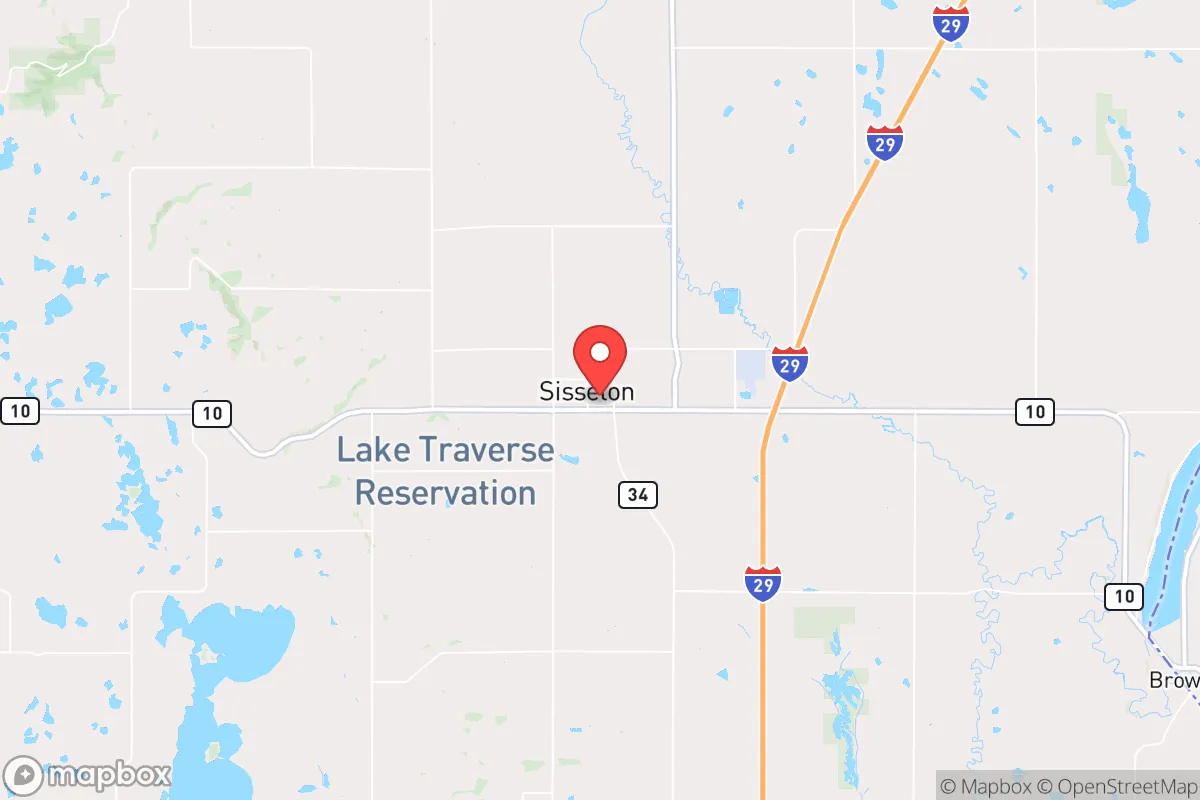
Sisseton, South Dakota, offers a strategic relocation option for those prioritizing resilience and distance from major population centers, sitting roughly 50 miles from the South Dakota–Minnesota border and 90 miles from Fargo. The town’s location in Roberts County places it within the Lake Traverse Reservation, providing a buffer of rural, low-density terrain that complicates any large-scale movement of people or resources through the area. For a prepper or survivalist, this isolation is a double-edged sword—it reduces exposure to urban unrest and fallout risks but demands self-sufficiency in logistics and supply chains.
Geographic position and natural advantages for long-term survival
Sisseton’s geography is defined by the Coteau des Prairies, a plateau that rises 200–400 feet above the surrounding plains, offering natural observation points and defensible high ground. The area is part of the Prairie Pothole Region, with hundreds of small wetlands and lakes—like Lake Traverse and Big Stone Lake—that provide reliable freshwater sources even during drought. The climate is continental, with cold winters (average January lows around 2°F) and warm summers (July highs near 84°F), which limits growing seasons to roughly 120–140 days but reduces pest pressure and disease vectors common in warmer regions. The nearest major city, Fargo, is 90 miles north, while Minneapolis is 180 miles southeast—far enough to avoid immediate fallout from a nuclear event or civil unrest in those metros, but close enough for occasional supply runs if conditions permit. The area’s low population density (about 12 people per square mile in Roberts County) means fewer neighbors to compete with for resources, but also fewer potential allies or labor pools for community defense.
Risks, exposures, and proximity to fallout-relevant landmarks
The primary risk for Sisseton is its proximity to the Lake Traverse Reservation’s governance structures, which could complicate land use or resource rights during a collapse scenario—federal trust land status means property ownership is less straightforward than in non-reservation areas. The town sits about 70 miles from the nearest interstate highway (I-29), which could become a chokepoint for refugee flows from Fargo or Sioux Falls during a crisis. Fallout risks are moderate: the nearest nuclear power plant is the Monticello plant near Minneapolis (180 miles), but prevailing winds from the west-northwest mean any release from that facility would likely blow away from Sisseton. More concerning is the proximity to the Grand Forks Air Force Base (110 miles north), which hosts nuclear-capable bombers and could be a target in a conflict—though the base’s strategic value has declined since the Cold War. Tornadoes are a seasonal hazard (EF2–EF3 events occur every few years), and the flat terrain offers little natural shelter from storms. The area’s reliance on a single major road (US-12) for east-west travel creates a vulnerability: a bridge failure or blockage at the Lake Traverse outlet could isolate the town for days.
Practical resilience for a relocator: food, water, energy, and defensibility
Water is Sisseton’s strongest asset—the Big Stone Aquifer underlies the region, and surface water from Lake Traverse and the Whetstone River is abundant, though treatment is necessary for drinking. The town’s municipal water system draws from wells, but a prepper should plan for a private well or rainwater catchment, as grid failure would halt pumping. Food production is viable but limited: the growing season is short, but cold-hardy crops like potatoes, turnips, and winter wheat thrive, and the area’s grasslands support cattle and bison ranching. Local hunting (deer, pheasant, waterfowl) and fishing (walleye, northern pike) provide protein year-round. Energy is a weak point—the grid is served by Otter Tail Power, which relies on coal and natural gas, with no significant local solar or wind infrastructure. A relocator would need off-grid solar panels with battery storage, as winter cloud cover can reduce generation by 50% for weeks. Defensibility is moderate: the Coteau’s ridges offer natural chokepoints, but the town’s layout is spread out, with few hardened structures. The nearest hospital is in Sisseton (a critical access facility with 25 beds), but trauma care requires a 90-minute drive to Fargo. For a single individual or family, a rural homestead 10–15 miles outside town—on a dead-end road with a creek—would provide better security than in-town living, where a population of 2,500 could become a target for looters or refugees.
The overall strategic picture for Sisseton is one of trade-offs: it offers genuine isolation and water security that few Midwest locations can match, but demands serious investment in energy independence and medical preparedness. For a conservative-leaning relocator concerned with societal collapse, the area’s distance from major cities and military targets is a clear advantage, but the reservation land status and limited road network create vulnerabilities that require careful planning. The town itself is not a prepper paradise—it’s a working-class community with a median household income around $45,000 and a reliance on agriculture and tribal government—but the surrounding countryside provides the raw ingredients for a resilient lifestyle if you’re willing to accept cold winters and a 90-mile drive for a hospital. In a worst-case scenario, Sisseton’s location on the Coteau could serve as a redoubt, but only for those who arrive with their own power, water treatment, and a willingness to navigate the complexities of tribal jurisdiction. It’s not a bug-out location for the unprepared—it’s a long-term homestead for the disciplined.
* Values derived from national, state, county, city and local statistics and may differ in a specific area. Last updated: 2026-04-23T02:22:25.000Z
Narrative content on this page is AI-generated and may contain mistakes. Verify any details that matter before acting on them.
ReloMaps may earn a commission from affiliate links at no extra cost to you.