Photo: Wikipedia
Strategic Assessment of Yankton County
Strong survivability profile. Good buffer from population centers, with manageable environmental and tactical risks.
What does the Strategic Assessment tell us?
Our Strategic Assessment grades tactical survivability of an area. Major population centers, military targets, fallout zones, natural disasters, and border exposure all drive risk — lower exposure means a more defensible position in a crisis.
This is heavily inspired by Joel Skousen's Strategic Relocation book. Highly recommended you checkout the book ($)What does this tell us?
Our Strategic Assessment grades tactical survivability of an area. Major population centers, military targets, fallout zones, natural disasters, and border exposure all drive risk — lower exposure means a more defensible position in a crisis.
This is heavily inspired by Joel Skousen's Strategic Relocation book. Highly recommended you checkout the book ($)Strategic Pillars

Key Distances
Strategic Assessment Analysis
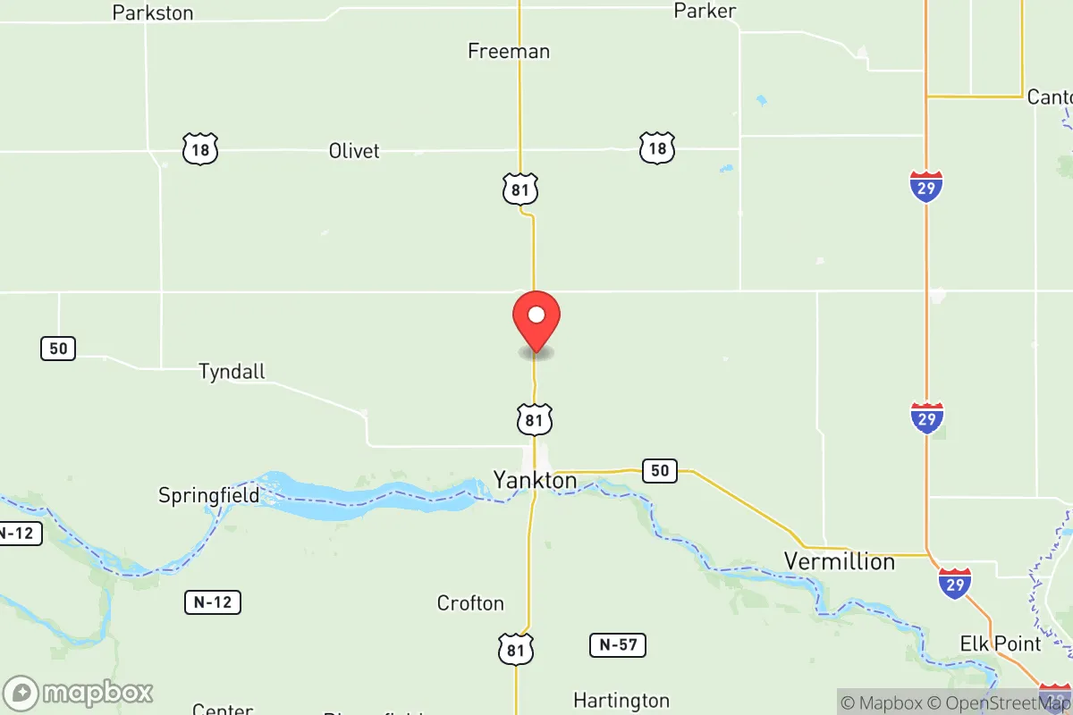
Yankton County, South Dakota, sits in a sweet spot that few relocators fully appreciate until they map out the risks. It is far enough from the major population centers of Sioux Falls (about 60 miles northwest) and Omaha (roughly 100 miles southeast) to avoid the immediate blast zones, fallout plumes, and post-collapse chaos of those cities, yet close enough to access their medical and supply networks during stable times. The county’s position along the Missouri River provides a reliable water source, and its agricultural base means food production is local, not trucked in from a thousand miles away. For a conservative-leaning individual or family looking at long-term resilience—whether from economic collapse, civil unrest, or a mass casualty event—Yankton County offers a defensible, resource-rich anchor in the Upper Midwest.
Geographic position and natural advantages for long-term survival
Yankton County’s geography is its strongest card. The Missouri River cuts through the county’s western edge, creating a natural barrier and a perennial water supply that doesn’t depend on municipal treatment plants or grid-powered pumps. The river valley is fertile, supporting row crops like corn and soybeans, and the surrounding bluffs offer elevated terrain for observation and defensive positioning. The county seat, Yankton, sits at the confluence of the Missouri and the James River, giving residents two water sources and multiple evacuation routes via US Highway 81 and State Highway 50. The Lewis and Clark Lake, formed by the Gavins Point Dam just west of Yankton, provides a massive reservoir that could sustain a community for years without rainfall. The dam itself is a double-edged sword—it generates hydroelectric power and regulates flooding, but it also represents a critical infrastructure target. Still, the county’s low population density (roughly 23,000 people across 530 square miles) means fewer mouths to feed and less competition for resources in a crisis. The nearest major military installation is Ellsworth Air Force Base near Rapid City, about 300 miles west—far enough to avoid base-related targeting but close enough to benefit from any regional security response.
Risks, exposures, and proximity to fallout-relevant landmarks
No location is immune to risk, and Yankton County has its share. The most obvious exposure is the Gavins Point Dam. If a coordinated attack or sabotage took out the dam, the downstream flooding would devastate Yankton and the surrounding lowlands. The dam is a known strategic asset, but its rural location makes it less likely to be a primary target than, say, the Fort Randall Dam further upstream. The county is also within 100 miles of the Sioux Falls Regional Airport and the rail yards in Sioux City, Iowa—both potential secondary targets in a conflict scenario. Fallout risk is moderate: prevailing winds typically blow west to east, so a nuclear event in the Black Hills or the Rocky Mountain corridor would likely push contamination away from Yankton County. However, a strike on the Minuteman III missile silos scattered across western South Dakota (around 150 miles west) could produce localized fallout if winds shifted. The county has no major refineries, chemical plants, or nuclear power stations within its borders, which is a net positive. The nearest refinery is the CHS Refinery in Laurel, Montana, over 500 miles away. For a relocator, the biggest practical risk is not a direct hit but the influx of refugees from Sioux Falls, Omaha, or even Minneapolis (about 250 miles northeast) if those cities collapse. Yankton’s bridges across the Missouri—the Discovery Bridge and the Meridian Bridge—are chokepoints that could be defended but also funnel desperate populations into the county.
Practical resilience for a relocator: food, water, energy, and defensibility
For a family or individual serious about self-sufficiency, Yankton County checks most boxes. Water is the non-negotiable first priority, and the Missouri River provides it in abundance. A simple hand pump or solar-powered well on a rural property can yield clean water without relying on the Yankton city system. The county’s agricultural land means local food production is viable year-round—greenhouses in winter, row crops in summer, and livestock operations throughout. The Yankton Farmers Market and local CSAs are functional now, but in a collapse scenario, the real value is the network of small farms and ranches that dot the county. Energy is a mixed bag: the grid is reliable in normal times, but the Gavins Point Dam provides a local hydro source that could be tapped with small-scale micro-hydro setups along the Missouri’s tributaries. Solar is viable, with the region averaging over 200 sunny days per year. Defensibility is where Yankton County shines. The terrain is a mix of open prairie and wooded river breaks, offering both fields of fire and concealment. The county is not a natural invasion corridor—no interstate highways run through it, and the major roads are two-lane state highways that can be monitored and blocked. The population is predominantly rural and conservative, with a strong hunting and firearms culture. The Yankton County Sheriff’s Office is professional but small, meaning community self-defense networks would likely form organically. The nearest National Guard armory is in Vermillion, about 30 miles north, which could be a stabilizing force or a target, depending on the scenario.
Overall, Yankton County presents a strategic picture that balances opportunity with honest risk. It is not a fortress—no place is—but it offers the core ingredients for long-term resilience: abundant water, arable land, low population density, and a defensible geography. The proximity to the Missouri River and the Gavins Point Dam is both an asset and a liability, but the dam’s rural location and the county’s distance from primary targets make it a better bet than most riverfront counties further south. For a conservative relocator who values independence, community, and preparation, Yankton County deserves a serious look. The key is to secure a property with direct river access or a deep well, build relationships with neighbors before the crisis, and have a plan for the refugee flow that will inevitably come from the east. If you can manage those variables, this corner of South Dakota offers a fighting chance.
* Values derived from national, state, county, city and local statistics and may differ in a specific area. Last updated: 2026-05-27T19:50:13.000Z
Narrative content on this page is AI-generated and may contain mistakes. Verify any details that matter before acting on them.
ReloMaps may earn a commission from affiliate links at no extra cost to you.